Iceland has become a very popular destination in the last years as it is advertised almost non stop in magazines and on TV and we decided to take a one week plus trip around the island using the circular road that encircles it called appropriately the Ring Road. The flight is shorter than the usual Europe flight however getting the car takes some time as the shuttle seems to be quite slow and we wait for 30+ minutes for it with an additional 30 minutes in the car rental agency. In the airport we exchange money (which is a great decision given the paucity of choices afterwards) and buy a card that we intended to use at automated gas stations but unfortunately we learn later is only a simple cash card which can't be used exactly where we wanted to use it even though the customer rep implied otherwise (which is a bad decision as we spend most of our trip just trying to empty our balance and to make up at least part of the fee we were charged).
At the airport - typical weather
Car rental place
As soon as we pick up our SUV (a Subaru Outback) we are on way towards our first stop, the Bridge between two Continents which is quite close to the airport. While it is a tourism gimmick - a bridge spanning the rift between the continental plates of Europe and North America it is a good introduction to one of the major claims of fame for Iceland - it sits on top of the continental rift which makes the island quite tectonically active. We wander around taking pictures from all angles and exploring the surrounding area before continuing on our way.
Trail to the Bridge between two Continents
The bridge between the two plates
Interpretative sign in the middle of the bridge
View from the other side
Rift between the continents
Iceland wilderness
Next stop is quite close also and is split into two points of interest - Valahnukamol near the Reykjanes Lighthouse and Gunnuhver Hot Spring. First we go to the end of the road and Valahnukamol. The parking lot is below the lighthouse and from here it is a 0.3mi hike to the shore and the interesting rock formations. Also here is a statue of a Great Auk commemorating the killing of the last Great Auk in Iceland and the world on a nearby island. A bit grizzly but a reminder of the impact people have especially on small islands.
Parking lots are always quite full
Seaside cliffs
This looks like an ideal place for seabirds
There it is - the extinct Great Auk
To return to the parking lot we choose a different trail that passes near the cliffs and some ruins before turning towards the parking lot. It is a less popular area and we even see a few birds along the way. The weather however continues to be quite depressing, cold with heavy cloud cover however no rain yet which gives us some hope.
Cliff views
Ruins near the trail
Lighthouse in the distance
One of the birds along the trail
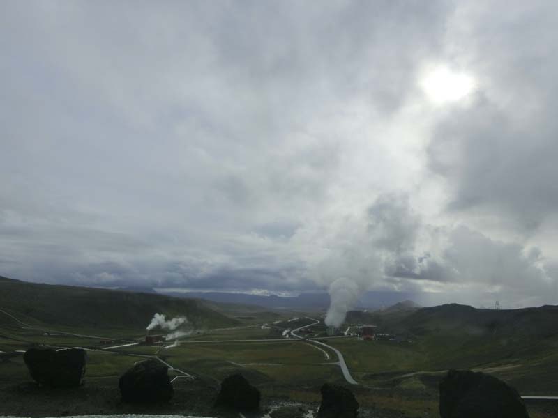
From the parking lot we take the car back to the first intersection and right into the parking lot for Gunnuhver Hot Springs. It is a short distance that some people are walking however we are right after an overnight plane with no time to rest so driving is what we choose. Gunnuhver recent claim to fame is that in 2006 it expanded encompassing the boardwalks and it was completely closed to the public until more recently new boardwalks were set up. However it is famous from medieval times due to the legend attached to it about an old woman named Gudrun, “Gunna” for short, who lived in a small community on the Reykjanes peninsula sometimes in the 18th century. She was suspected of being a witch and after dying her spirit terrorized the peninsula, wreaking mayhem. Ultimately using a priest’s advice they set a trap for the ghost; they left a loose end from a ball of twine for the ghost to grab hold of and then the ball rolled into the hot spring, taking the witch’s ghost with it and trapping her there forever. Now the area is still a highly active geothermal area of mud pools and steam vents which creates an eerie atmosphere.
Gunnuhver Power Plant
Gunnuhver Hot Springs
The walkway destroyed during the eruption
Colorful ground
Our next stop is Grindavik to buy some provisions from a small "netto" supermarket given that we don't know when we will have the opportunity to do that in the future. And then it is time again to do a side trip to the close by Hopsnes peninsula to visit the wreck of ships that ran aground on this small peninsula. And there are quite a few of them, most signposted with some interesting info. The lighthouse is also of interest (even just in reflecting on why it didn't prevent the ships to run aground :)).
Hopsnes peninsula wreck
Part of the wrecked ship
Biggest part from the ship we found
Hopsnes Lighthouse
Continuing on road 427 our next stop is Selatangar and old abandoned fishing village. THe road to the parking lot is bumpy but not to difficult and from the parking lot a well defined 0.5 mi trail takes us to the ruins. The vegetation is different here with a nice moss covering (there are almost no trees left) and soon we are close to the sea where we spend some time just examining the different items that were brought in by the tide- many of them are fishing related and no coconuts here.
Path to Selatangar fishing village
Desolate area
Plant growing in black sand
Icelandic moss
Beach near abandoned village
This is more modern
Close the beach is the abandoned fishing village. It is in a picturesque location among the rocks and we enjoy exploring all the different nooks and crannies. The most interesting ruin is on top of a small hill which likely would have provided a good view of the sea (if there would be no clouds which seems unlikely given our experience :)). From here we return to the car and continue on our way.
Arriving at the village
Wall ruins
Abandoned fishing hut
Looks like a small fortress from here
The last stop on the coast before turning inland towards our hotel is at the Strandarkirkja. As most places in island there is a legend related to the place - during a storm the sailors from a stricken ship prayed to God for a safe return and vowed to build a church wherever they landed and when an angel helped them they built a wooden church at the site and named it Strandarkirkja. Our interest however is more with the seals that hang around in the sea quite commonly in the area and that we see after taking a short hike along the shore.
Strandarkirkja from a distance
Close up
Walking along the seawall
Can you see the seal?
Our last stop of the day before the hotel is at Kerid crater. Our initial plan was different however as we are quite tired already we decide to go via Kerid to our hotel near Geysir. Kerid a formerly free (now fee based) attraction is very popular, even finding a parking spot is a challenge in the relatively small parking lot. Kerid is a small crater filled with a small lake and it's claim to fame are the beautiful colors and the contrast between the green of the lake and the red of the crater walls. You can walk around the rim or descend into the crater if desired.
Kerid crater - beautiful colors
Zooming in on the lake
Lots of people on the crater rim
Everywhere really
The hotel is about 30 minutes from Kerid and after checking in we crash for the day with the only dinner being the provisions we bought earlier in the day. Our hope is to catch up the next day on all attractions we have seen but only time will tell.
We wake up relatively early in the morning as we are hungry:) and ready for breakfast. It is quite a varied buffet style breakfast and satiated we check out and move only a couple hundred meters to another parking lot for the first stop of the day.
Breakfast buffet
Sampling everything
The Geysir area like quite a few other popular areas in Iceland is teetering on the edge between being free and charging for admission but during our visit it is free entry. It encompasses multiple steam vents and a few geysirs from which only one (Strokkur) is erupting regularly. Still the major claim to fame is another geyser called Geysir from which all other geysers around the world were named for. We start near the closed visitor center and pass a few smaller attractions towards Strokkur hoping to see an eruption at least.
Geysir geothermal field
Smelly river
Litli Geysir
Waiting for Strokkur eruption
Actually seeing a Strokkur eruption is not that difficult as it erupts every 6-10 minutes and we actually capture three of them during our visit, each of them with different heights and duration. It is quite interesting also to watch how the water level varies as it gathers in the spout before the eruption. Of course you have to be careful of the prevailing wind direction otherwise you might get rained upon:).
Right before the eruption
Strokkur eruption
The spout after the eruption
Another impressive eruption
Between the eruptions we visit the rest of the park including the original Geysir which seems quite placid now but has quite a big pool to draw water from. Other interesting sights for us are the deep blue pools of a few springs - the contrast with the surrounding area is quite strong.
The original Geysir
Not erupting anymore
One of the pools
Deep blue color
Close to Geysir (about a 15 minutes car ride) lies the Gullfoss waterfall. With Kerid, Geysir and Thingvellir Gulfoss is part of the Golden Circle - a very popular route for day trippers from Reykjavik. The waterfall is very impressive and there are multiple trails reaching viewpoints both above and near the waterfall. What is difficult is to avoid to water spray - it is almost everywhere today besides the rain which makes taking photos quite a challenge but we manage somehow:).
First view of Gullfoss
Better view away from the water spray
Side view of the waterfall
River above the waterfall
From Gulfoss we are moving on towards Thingvellir National Park, the last stop on the Golden Circle for us before continuing east on the ring road. We choose a side road to access the central area which has the advantage that it passes near a large lake - we stop in a few places to birdwatch and just enjoy the nature without any other tourists (that is at a premium here).
Typical Iceland road
Thingvallavatn Lake
Geothermal vents are everywhere
Ground cover
Finding a parking spot in Thingvellir, an Unesco World Heritage site, seems like a fool's errand but after going in circles for some time we catch an open spot and after paying for the parking fee we start our exploration of the historical area. Thingvellir is famous as the site of the first Icelandic Parliament, the Althing which is also assumed to be the oldest parliament in the world. The location is certainly well chosen with some impressive natural features - we chose to go first to the Oxararfoss waterfall which is closest to our parking lot.
Well marked - as long as you know what they mean
Geese enjoying the grass
Trail to Oxararfoss
Healthy moss
Oxararfoss while smaller than other Icelandic waterfalls is quite pretty as it falls down the cliffs into the rift/canyon continuing down through it until the lake at the base of the mountains. It is also historically important as the pools at the base were used to drown women accused of infanticide, adultery, or other crimes.
Oxararfoss
River continuing through the rift
At the base - execution place
The end of the rapids
From the waterfall we descend to the Logberg where the Althing assembled. There is not a lot left from those times as the meetings were open air and not in any buildings really but you can imagine the people assembled on the grassy knoll and the surrounding area for a week or so deciding on all the important matters for the island. From the Logberg we walk up through the rift towards the visitor center where we look for souvenirs and examine the exhibits before returning to the trails.
Logberg - first parliament site
View from Logberg
Walking from Logberg to visitor center
Wasps are somehow surviving even here
Before descending towards the Thingvellir church we enjoy the expansive views from the overlooks near the visitor center and then we follow a little used (and not clearly marked) path down towards the river from where a boardwalk leads towards the church entrance.
View from visitor center
Our next goal - Thingvellir Church
Boardwalks - common and useful
Large river
The Church while small is well integrated in the landscape. It is an important church in Icelandic history as nearby the decision was made to switch from Paganism to Christianity and during the following years it was the closest church to the Althing and the de facto national church. The church now on the site was consecrated in 1859 and is likely much smaller than the original one that stood on the site. Close by is also a small cemetery housing between others the graves of two independence-era Icelandic poets.
Thingvellir Church from a distance
Close up of historic church
Small cemetery - some famous Icelandic people rest here
Cute tombstone
Small islands in the river
Beautiful creek
From Thingvellir we pass through heavy rain returning to the Ring Road and after a quick stop in Selfoss to buy gas for the long road ahead we enter the area that could be easily called Waterfall highway as we encounter three magnificent waterfalls in a row. The first one is Urridafoss which is less popular than the other two while being still as impressive. The difference is that Urridafoss has a greater width than height so it seems less impressive but it is by volume the largest waterfall in the country.
Urridafoss with highway bridge in background
Even has a small rainbow
Next waterfall is Seljalandsfoss - given that the rain is falling steadily and the parking is fee based we waver a bit whether to stop or not but in the end we decide to stop as this waterfall is famous for the fact that you can walk behind the waterfall and given the rain we think it can't make us any more wet. Unfortunately the path is closed (of course with no sign in the parking lot) so we can only admire it from a distance while trying to take photos before retreating back to the car.
Seljalandsfoss in the distance
Close up of Seljalandsfoss - it is huge
The last waterfall of the day is Skogafoss. The rain has not stopped and is falling steadily and the waterfall produces a lot of spray so even with a lot of tries we cannot get a great photo of the waterfall which is impressive with a drop of 60m and a width of 25m. You can climb to a platform above it but today was not a good day to do it as we are already drenched so we skip the top platform. You can continue on a hiking trail above the fall to see quite a few other smaller waterfalls - maybe another time with better weather.
Not the place I would pick for camping
Skogafoss
After Skogafoss the rain subsides so we decide to make one more stop before Vik at Dyrholaey, where we will stay for the night. Dyrholaey is close to Vik and is famous for the great views and rock formations and we get a glimpse for them as we take the side road taking us to the water shore.
Road toward Dyrholaey
Shallow lakes near
Dyrholaey is famous also for the seabirds that nest here but the puffins are gone and we see only few birds that are circling the cliffs. The views, especially of Kirkjufjara beach, are however special and we enjoy the walk for some time before the cold+wet clothes get to us and we retreat to the car. Right next to the parking lot there is construction going on, it seems that they want to introduce a fee system in the future so we are happy we made it here before the construction is finished.
Signs can be quite useful
Cliffs supposedly full of birds
Kirkjufjara beach
Monolith in water
Before the beach access we notice a side road that goes up towards a hill top and after noticing a few cars managing to climb the slope we decide to try it also even though there are only 15 minutes left before the official closing time of the park. At the top is the lighthouse and a short trail along the butte leads to some exceptional views of the beaches, sea and a rock jutting into the sea with three arches which is quite interesting.
Dyrholaey Lighthouse in the distance
Close up of lighthouse
Sunspot on the sea
Multiple arches
Neverending beach
Nice view from our vantage point
After this it is time to return to the main street however we are held back for some time by a group of sheep crossing the street - the sheep here have some impressive wool in our opinion probably to keep warm. We wish we would have something similar with the alternating rain, cold, wind we feel like we are catching a cold which is unfortunately confirmed when we reach the hotel where we sit in our room for the evening drinking tea and hoping that next day we will feel better.
Today before leaving we want to get something to eat for breakfast from the supermarket (not many choices in Vik) so we explore the small village waiting for the supermarket to open at 9AM. Specifically we drive to the church which has a nice vantage point above the village and is the meeting point in case of a volcanic eruption that can cause the close by glaciers to melt and destroy the village. When the supermarket opens we are the first people through the door and after buying some baguettes and coffee we are on our way.
Hotel in Vik
Church on top of hill above hotel
Vik - endangered village
Supermarket that we are waiting for
Our next destination is close by, Storhellir (the Big Cave) accessed through a beautiful back road climbing up towards the Iceland interior until reaching the parking lot for the short trail to the cave. The cave is more like a grotto with a small pool inside but the views there and back were worth the short detour. While preparing to leave we notice the occupants of the only other car in the parking area returning and they are dressed quite skimpy compared to the weather - then we notice the camera, it seems they were shooting some professional photos.
Green valley
Sheep are everywhere
Road to Storhellir (Big Cave)
The cave
Continuing along the Ring Road we stop next at the Alftaver cone group, a less visited attraction just a short distance off the Ring Road. Here a relatively large area is covered by mini cones which are quite interesting to explore. The best vantage point is from the cone closest to the parking lot which has been set up as a viewing area with stairs leading to the top. After enjoying the view of the area and finally eating our breakfast we are ready to continue on our way towards Laufskálavarða.
River plain
Alftaver cone group
At Laufskálavarða the major attraction are the many small cairns that litter the field and a small hill next to the parking lot. They were erected for good luck before a particularly difficult stretch of overland journey by medieval Icelanders. The Icelandic Road Administration historically saw to it that there was always a good supply of rocks so that first time travellers could build their own small cairn for luck but this likely isn't the case anymore. We wander around the many cairns for some time exploring the area before continuing on our way.
Laufskálavarða cairns
Top of small hill with cairns
Fjaðrárgljúfur, our next stop, is a massive canyon, about 100 meters deep and about two kilometres long. The canyon has sheer walls, and is somewhat serpentine and narrow. You can hike up on the Rim for a vantage view from above or hike through the mostly shallow water into the canyon. As we are still feeling under the weather we choose to hike just to the entrance and inside to the first water crossing before returning to the car and continuing on as we have a few more interesting stops planned today that we don't want to miss.
Fjaðrárgljúfur - Icelandic canyon
Impressive from the right spot
Next we stop in Kirkjubæjarklaustur, it is not a planned stop but we notice an interesting waterfall from the road and decide to investigate. We find out it is called Systrafoss, the Sisters' Falls, which likely refers to the nuns who lived in the convent at Kirkjubæjarklaustur. The Sisters' Falls is special in that there are two equal waterfalls side by side, almost falling like two white rivers down the mountain slope. It also has a hiking path that climbs to the top of the cliffs and we decide to explore a bit to determine if we can get some better views of the waterfall.
Systrafoss from a distance
Systrafoss - more rapids than waterfall
Exploring a bit in the end actually means climbing to the top and to the source of the waterfall - a large lake on the plateau. There are sheeps around and lots of wildflowers and the views are quite good and we enjoy them as we catch our breath before descending.
View from top
That was a steep climb
Lake on the plateau
Flower on top
Close to the waterfall is an attraction that we actually intended to visit, the Kirkjugólf (church floor). It is an 80 square meter expanse of columnar basalt stone slabs which have eroded over time. The hexagonal ‘tiles’ look like they were man-made which is where the name is coming from as it was assumed a church was located here. However no historical record was found and it was confirmed that the columns are natural. The interesting area is reached by a short hiking trail from the parking lot and it was well worth the visit.
Interesting rock formation
Green fields
Kirkjugólf (church floor) is a natural phenomenon
Close up of Kirkjugólf
From Kirkjugólf we continue towards the glaciers passing multiple waterfalls along the way but stopping only at one that was most impressive in our opinion, Foss a Sidu. Unfortunately it is on private land so we have to take the photos from a distance. Same for the first turf houses along the trail - even though supposedly they were visitable according to our guide now the road is locked, so no admittance anymore and we have to take photos from the road.
Foss a Sidu waterfall
Turf houses along the way
Afterwards we start to approach the glaciers and the Skaftafell National Park and the views in the distance are dominated more and more by white as the impressive glaciers come into view. Before entering the National Park we stop at the remains of a bridge which was completely destroyed by a Jökulhlaup (glacier run) in 1996 after an eruption nearby melted part of the glacier. The new bridge is still under construction now :).
Glacier in the distance
Becoming more impressive
Quite close now
Remains of destroyed bridge from Jokulhlaup
Because we don't have that much time to hike we pass the main entrance (which seems to be crazy full even with the newly introduced fees) and continue a bit past to the nearby dirt road which while still popular is free. After finding a parking spot with difficulty we start on the obvious hiking trail to the first vantage point of the ice floats in the glacial lake at the base of the glacier. It is a nice view and you can feel the cold coming from the glaciers and water we have to bundle up even though it is sunny outside (a rarity).
Lake full of ice
Glacier is breaking down
We continue along the lake as the trail becomes more and more precarious until the main glacier comes into view. It is impressive and we wouldn't dare to continue on it especially now when crevasses can appear from nowhere - there are a few graves along the trail just to remind everyone how dangerous that can be. The glacier here has appeared in quite a few movies including Batman Begins and Interstellar and one of the things that supposedly you can see on revisits is how much it retreats even in a few years - the trail to reach or even view the glacier is much longer than it was a few years ago.
Path continues further up
The path is quite narrow here
Impressive glacier tongue
And that is the glacier
Between glacier viewings we stop at Hof along the way. This was not a stop we planned really however we are glad that we followed our guidebook as here we see the first turf church on our trip (which is quite interesting) and it is easily accessible with its own parking spot. It even has a restroom which is very important in Iceland as otherwise they are difficult to find leading to an environmental issue that all Icelanders decry (even though they should we the ones to fix it from the exorbitant fees that are charged)- not a lot tourists can do).
Hof church
Old something:)
Before Hofn we have two more stops planned at a couple of famous glacier locations where you can even take tours to get close to the ice floats. The first one is Fjallsarlon where parking is not a problem which is always a nice surprise in Iceland. From the parking lot we climb on a small hill to view the glacier and the lake with the ice floats. Afterwards we continue till the end of the trail - a bridge destroyed by a glacier run which likely is the reason that the road was moved further up and the bridge built higher.
Fjallsarlon parking lot and trail
Fjallsarlon glacier
Destroyed bridge
Tour boat on lake
Returning we enjoy the great views of the glacial lake and the ice floats, there are quite few tourists now on the shore as most have taken the boat and are on the lake so that provides us an opportunity to have a moment of solitude to soak in the views. To our delight we also catch a flock of geese passing in front of the glacier, they fly quite low and we hope for one moment that they will land but in the end they decide to pass without stopping.
Lake with glacier in the background
Close up of glacier
Geese flying low in front of glacier
One last look
Our last major stop of the day is Jokulsarlon the most famous glacier lake in Iceland. We first stop on one side of the lake where it is relatively easier to find a parking spot and are happy to notice almost immediately a few seals in the water. They seem quite used to the throngs of people while they go about their business (which mostly seems to be playing with each other) and we enjoy their antics for some time while walking along the shore. The weather is still good with the sun countering the cold from the ice and the lake.
Jokulsarlon - lots of people and seals
Close up of seal
While this is not the major viewpoint for Jokulsarlon the views are quite good with the ice floats having some fantastical shapes including mushrooms but the most interesting pieces are the transparent ones as they seem to be almost always on the verge of breaking apart.
Ice broken from the glacier
Those are some big chunks
Mushroom like ice piece
Transparent ice
Continuing to the other side we almost give up finding a parking spot but after minutes of searching we catch a break and join the throngs of people at the most popular viewing site where the ice floats congregate. It is almost impossible to get close to the shore for a good picture but you can climb on the nearby hills which are a bit more empty.
Second viewing area - closer to the ice...
...and the seals
Every ice piece seems to congregate here
Would not like to take a boat through here
Besides the viewpoint many people people take the famous boat tour which actually is an amphibious vehicle tour as we soon learn. We decide to pass and just walk around the shore for a bit even catching a ice float split as it happens - the sound associated with the split is unexpected and quite scary.
Tour boat in the water
And on land
Before the break..
and after
After leaving the glacier area we don't really stop anymore along the way arriving as the sun sets at our hotel near Hofn. After settling in in our room in the new wing we decide to eat dinner today in the restaurant as we feel just a little bit better from our cold. we especially wanted to try some lamb which seems to be a specialty here and it is quite good at a reasonable price (for Iceland). Afterwards we retire for the night - tomorrow we have a long drive however there are relatively fewer attractions on the way.
This morning before leaving we have time to enjoy the views from the hotel - the previous day we came in late just before nightfall and it was quite cold and dark already when we settled in and went outside.
Our part of the hotel
Glacier view from hotel
From the hotel we drive to Hofn to buy some gas as the gas station right across the hotel is automatic only and it does not accept our American credit cards. Continuing today the plan is to drive up the eastern coast until the Myvatn Lake area up north where we will spend two nights.
Hofn Peninsula View
Roadside art
One of the few tunnels
One of the many bridges
We do no really have any major stops planned and decide to stop whenever we see something interesting - a lighthouse with some nice views of the seashore qualifies and we hike along the shore a bit even finding a broken egg - the bird is likely long grown up.
Typical mountain landscape
Lighthouse on the hill
Seashore
Impressive mountain
At the ocean's edge
Broken egg
Soon the road starts to climb and descend the hillsides as the sea is much more closely to the mountains. We stop again when it the road touches the coastline again as the views are beautiful and the weather is great for some short hiking.
Stopping for the views
Seashore view
One of the preplanned stops is at Eggin i Gledivik an interesting outdoor artwork. The artwork consists of 34 eggs, one representing each of the species of local birds. The eggs are all similar in size except for one, which is the largest one and belongs to the red - throated diver, the characteristic bird of Djupivogur. You can park right next to them and walk from egg to egg and there are some good views of the harbor. It also seems a popular area for an early lunch with many cars parked with the people sitting inside eating lunch.
Eggin í Gleðivík - seabird eggs
One of the eggs
Next we stop at a waterfall that attracts our attention from the Ring Road. We later learn it is named Sveinsstekksfoss and we find a dirt road that accesses a parking lot from which a short hike leads to an overlook. A very unprotected overlook right as it starts to rain so we take a few photos of the waterfall and the canyon before returning carefully on the now slippery stones to the car. Next to the car park we notice an interesting notice - do not go to toilet in the woods - another sign of the tension between land owners and tourists.
That is a weird sign
Sveinsstekksfoss Waterfall
Looking down the waterfall
Impressive canyon
From here the weather is so variable that it is hard to predict how it is outside even a few minutes out. Sometimes it rains sometimes it is sunny sometimes it rains and it is sunny and sometimes it is all rainbows and the like. We stop in a little village along the way as we notice an abandoned boat in a meadow and a trail leading to it so we decide to explore it. You can actually enter it and explore which is fun for a few minutes before continuing on our way.
Interesting waterfall
Rainbow on the way
Abandoned ship
On the boat
Instead of using the Ring Road only we take the more scenic Fjord route which follows a few of the Fjords on the eastern coast before cutting through a mountain using a tunnel and arriving at Reyðarfjörður where we refill the tank at eat at the gas station fast food shop as Icelanders do. There aren't a lot of opportunities to stop along the way only one lighthouse beckons to us and we walk to it from a side road to some nice views of the shore and a lot of seabirds.
Tunnel through the mountainside
Shipyard
Orange lighthouse
Eider ducks
Returning to the Ring Road it cuts more inland from here and it climbs and descends regularly with the temperature sometimes seemingly descending towards zero Celsius while never reaching it. This is good as here the weather finally settles into a monotone gray with rain showers being quite common. The only stop here is at a waterfall which has a maintained parking lot but with no toilet which makes walking off path a risky endeavor.
Waterfall near rest stop
Old bridge
Road through the mountains
Bridge over Jökulsá á Fjöllum river
Our last major stop planned is at the Hverir geothermal area already close to Myvatn. We hesitate a bit on whether we should stop now with the on/off rain but there is no guarantee that tomorrow will be a better day so we decide to stop. Here the fog mixes with the gases from the steam vents for some otherworldly sensation. Sometimes you cannot see a few feet in front of you and sometimes it clears up for a few seconds just enough so you can get a glimpse of the area. We decide to hike a bit around to explore the area if at all possible given the mud.
Hverir geothermal area
You can't see anything at times
Avoiding the mud is more difficult than we expected but it is worth to explore the area as there are quite a few mud volcanoes making interesting sounds and seemingly erupting continuously - with all the rain that does not surprise us.
The smell is "interesting"
A steaming mud volcano
Even more interesting are the steam vents. We have seen some previously but we don't remember another one being as active or as load as the ones here. And of course the smell is overpowering at least when the gases are blown directly in your direction - not sure how healthy that is :).
Some of the many mud volcanoes
A steam vent
On the way to our accomodation we make a brief stop also at the Nature Baths which would have been interesting to visit if we weren't still sick so we just look from the outside before returning to the car and driving the short distance to our hotel. This evening we decide to sit in and eat from our provisions and gain some energy before the next day which promises to be very busy as there are many attractions around Myvatn.
After a good breakfast we are ready for our Myvatn Lake tour which is what we plan to do today. Our hotel is right on Lake Myvatn and has a nice location with some good views but it also means that it is at least a 10 minutes drive to any village to buy food or eat at a restaurant so it is good that we don't plan to do neither.
Our hotel
View from the room
First stop on our tour is at the Skútustaðagígar pseudo craters which were formed by gas explosions when boiling lava flowed over the wetlands. Now the landscape is basically littered by mini craters which makes for some scenic views. There is a short loop hiking trail going through the craters and we decide to hike it - we have to be fast as a tour bus stopped right behind us which when unloaded would make the trail quite busy. We find the entrance fast and after making sure that we do not follow any sheep :) we are on our way through the craters.
Skútustaðagígar pseudo craters entrance
Do not follow sheep - really?
Pseudocraters
Myvatn Lake
You can climb a few of the pseudocraters for some nice views including inside them and they also provide good vantage points over the Myvatn Lake which we are interested in as supposedly there are a lot of waterfowl in the area. And it is true - from one of the craters we see a lot of waterfowl - mostly ducks and lots of swans and we admire them for some time before the mosquitoes come calling and it is time to go.
Pseudocrater near lake
View inside the crater
The trail
Waterfowl - most swans we have seen
Next we plan to stop at Hofdi but we are unaware there are two parking spots and we park first at the south one. This is actually fortunate as the trail here is less busy and is also quite scenic. It follows a peninsula that juts into the Myvatn lake and passes through fields with wildflowers and some nice views over the lake. We decide to hike for a bit as seemingly there are no mosquitoes here and the weather is quite good for a change. It is also a flat hike which is good at this time as we are still sick so a training hike is great.
Hofdi South Trail
Road in the distance
Enhanced colors
More vegetation than usual
Our turnaround point is at a viewpoint of the interesting rock formations and caves that are the attraction in the area. You can probably hike to a few of them but we have a lot planned for today so we return to the car.
Small caves in the rocks
Rock formations in the lake
Next we stop at the northern Hofdi entrance from which a trail leads into a rare Icelandic forest situated on a small peninsula. It is well marked and quite popular, it seems that after every bend we meet someone hiking or just relaxing. There are a few times that the trail touches the shore to some good views over the lake but otherwise it mostly goes inland past some caves and lots of old growth (for Iceland) trees. With the sun out it is a bit warm under the sun so it is nice to weave in and out of the shade as we follow the trail.
Main Hofdi entrance
Path sign
Trail near water
Cave in the forest
At the far end of the loop trail is probably the best viewpoint over the lake with the volcanoes far in the background and the rock formations closer to us. You can see the other peninsula where we hiked from here and we sit a bit enjoying the views before returning to the car.
Volcano on the far Myvatn shore
Myvatn - not a lot of waterfowl in this area
Dimmuborgir close by is our next stop. We are not sure what to expect - we know the major attraction is the "Church" but otherwise we are not sure what to expect. From the parking we go up the rim and we can see the whole area from above - it looks like a lava flow area with many formations shaped by wind and rain (which are in oversupply here). Looking back we can see Lake Myvatn but after descending in the valley it feels we enter a different more magical area which is reinforced by the elves hiding place that we find in a cave close to the trail.
Dimmuborgir area from above
View over Myvatn lake from Dimmuborgir rim
Interesting rock formation
Elves hiding place
As the area looks interesting and the weather is good we decide to hike to the "Church" which is an about 1 km hiking trail one way. The one defining feature of all the spires and rock formations we see is that all of them seem to have an arch so it is only appropriate that the "Church" is also an arch, sort of :). It is actually a lava tube which solidified in such a way that they entrance evokes the form of a church - we are glad we did the hike as it is a cool feature but now it is time to return to the car as we notice that rain clouds are gathering.
Path through Dimmuborgir
Another arch
More vegetation than usual
You can climb to some of the arches
Climb to the "Church" lava tube
The "Church"
Nearby is the Hverfjall Crater but with the weather taking a turn for the worse we decide to view it only from below without taking the hike up the crater rim as it looks like a typical crater similar to the other ones we have seen including Sunset Crater in Arizona. More impressive to us are the cows we meet on the way which seem thoroughly uninterested by the major traffic passing nearby.
Hverfjall Crater
Cows on the way
After Hverfjall Crater we leave the Myvatn shore and take a dirt road towards Grjótagjá cave. The cave sounds like an enticing destination on paper, a small geothermal spring in a cave where you can arguably even take a bath. It was featured in Game of the Thrones which made it quite fashionable to visit and now it is difficult even to enter it and bathing seems to be prohibited. Somehow we manage to make it in and the water color is quite special however with people almost pushing you in the water a few times the magic seems gone to us at least.
Above Grjótagjá cave
Entrance to the cave
Inside the cave
The water is boiling
Today we stop again at Myvatn Nature Baths for a better look at the pools. There are a few free outside observation decks from where you can see the baths but it is still cold so we decide to skip on taking a bath. There are quite a few that are a lot more adventurous as we can observe from the outside. There are two pools with one being more popular than the other one for some reason or the other. We also visit the souvenir shop and use the restrooms because who knows where the next free one will be.
Myvatn Nature Baths
One of the pools
Next we stop at the Krafla Caldera a cauldron-like geological feature - it still is an active volcanic area with many eruptions, the most recent of which was the Krafla Fires in the 1970s. Overall there are three main highlights to the Krafla area, Leirbotn (the geothermal power station), Víti Maar (a volcanic crater with an opaque, teal green lake) and Leirhnjúkur (steaming sulphuric terrain and multicoloured lava field landscapes). As it started raining we only stop at the crater to take a few photos before continuing to the waterfalls.
Moss covered landscape
Geothermal plant
Víti Maar -Krafla Lake
Colorful crater wall
The weather stays bad after Krafla which is especially when we start taking the dirt roads towards Dettifoss is a bit scary as we do not know how bad the roads can get in the rain. But it seems they are built sturdy enough and the biggest problem is the fog/clouds which limit visibility which is a problem with the cars coming back from the waterfalls. In the end we make it safely and from there we descend towards the canyon and then we follow the trail to the waterfall which is quite impressive - one of the biggest by volume in Iceland.
Road to the waterfalls
Dettifoss canyon
Close to Dettifoss
Quite impressive
Even though it is still raining we wander around the canyon for a bit to view the waterfall from a few different vantage points, there are multiple trails in the area some of them leading to other waterfalls but given the weather there is no way we can hike that distance so we return to the car to drive to the next waterfall instead.
Spray travels quite some distance
Impressive canyon
The second waterfall Hafragilsfoss is relatively close by but it is less famous and therefore there is less traffic to it. In fact there are only 2 cars in the parking lot compared to tens in at Dettifoss which makes for a more relaxed viewing. However compared to Dettifoss there is no easy trail down towards the edge of the waterfall so we admire the waterfall from the parking lot during a lull in the rain. Afterwards our plan is to find a village to buy some provisions and given the traffic back we decide to continue on the road and return a different way.
Hafragilsfoss from a distance
Close up
Given the route we decided on we pass on our return journey through the major city in this area, Husavik, and are able to buy at a supermarket some provisions - just in time actually as the supermarket closed as we exited it. We also find something to eat at the local gas station, all the restaurants are closed or very expensive so as all Icelanders we have to eat at the fast food joint at the gas station which is good enough. Afterwards we return back to our hotel and drink lots of hot tea to fight our cold before going to sleep as the next day we have a long drive ahead of us.
We start the day with another helping from the large breakfast buffet as we are not quite sure when we will be able to find lunch today and after checking out we are on our way. We are a bit disappointed as during the two nights we stayed here we were hoping (against hope) to maybe see the northern lights and while they were out in force supposedly of course the cloud cover prevented us from seeing anything.
Breakfast buffet
Quite a lot of choices
Our first stop is at Goðafoss, one of the many waterfalls in this area. It is historically important though as after the decision was made to convert to Christianity the pagan priest who made the decision threw the idols of the old Norse Gods into this waterfall. It is also very popular and we barely find a parking spot in the parking area from where a short trail leads us to the viewpoints. Other less popular hiking trails lead into the hinterland and we follow one along the river for some time before returning as we still have a long way ahead of us.
Goðafoss from a distance
Close up of waterfall
River above the waterfall
Iceland plains
One of the Iceland attractions that we really wanted to see where the turf houses so a stop at the Laufas turf houses was a must for us. About 20-30 people were living at Laufas including servants and it was mentioned in the records from the Settlement of Iceland way back around the year 900 but the houses are rebuilt in the 19th century. We wander around the houses for some time (there are quite a few of them) but we decide not to enter the museum as it is quite expensive compared to what it can contain in our opinion.
Laufas turf houses
Well preserved (or restored)
Some of them are almost buried
One of the bigger turf houses
The houses were restored by the local reverend and the church is the second architectural attraction at Laufas. It is a small church (no reason to be big), almost cozy and luckily most tourists don't know it can be entered as it would fill up fast. There is also an outside collection of agricultural implements and behind a fence we find also a few very placid Icelandic horses that let us take as many photos as we like :).
View from the back
Laufas church
Church altar
And the pulpit
Some of the historical machines
Icelandic horse
From Laufas we continue through the second largest Icelandic city, Akureyri, and pass a few more waterfalls and scenic spots where we stop only to take pictures given that today we have a long way ahead of us and also given that our accomodation might close check in early as it is a small guesthouse.
Coastal road
River view near Laufas
Old and new road bridge
Interesting side canyon
Our next stop is at Glaumbaer another preserved area with multiple turf houses. It is also mentioned in the Settlement Sagas and is historically important as it was here where Snorri Þorfinnsson, who was likely the first European born in America, lived in the 11th century. Here we enter the gift shop but avoid the museum again due to the high cost. The houses are not that different from Laufas but we enjoy them nonetheless and finally satisfy our curiosity regarding turf houses.
Glaumbaer turf houses
Close up of houses
View from back
Those are modern windows
From Glaumbaer we return to the Ring Road but right at the intersection we stop to eat lunch at the gas station and buy some gas. And then it is off to Borgarvirki the only Viking fortress that we found while exploring things to do in Iceland. It is on a dirt side road which is relatively well maintained and takes us up on top of a hill. From there a path takes us into a large basalt cone which has one entrance that was fortified - the walls were all natural. With no water it was likely only a temporary fort but the location is quite impressive.
Borgarvirki approach
View from the fortress
Natural walls
And the artificial entrance
Close to Borgarvirki is a relatively famous natural attraction, Hvitserkur, and from Borgarvirki we notice that the dirt road might continue right to it which would be great as otherwise it would be a half hour detour back to the Ring Road and then up a different dirt road to Hvitserkur. To our surprise we are right and we merge to the Hvitserkur dirt road and then soon arrive at the parking lot. From there a short hiking trail is going down towards the shore and viewpoint.
Country road
Path to Hvitserkur
Hvitserkur translates to “white shirt” and derives its name from being covered in guano. It rises 15 metres, or nearly 50 feet from the sea and was once the plug of a volcano, but over the years the craters surrounding the rock were eroded leaving only the unusual outcropping Hvítserkur behind. Curiously, Hvítserkur itself had to be shored up with concrete some years ago so it wouldn't fall over. It is an interesting formation and we enjoy the view from the viewpoint both of the rock and the black sand beach surrounding it.
First glimpse of Hvitserkur
Close up
Black sand beach
Nearby creek
When we leave Hvitserkur it is already late in the day so we decide to have no more stops as we drive direct to our accomodation as we are afraid we won't be able to check in if we are late. We shouldn't have worried as the key is left outside and we are actually the only people in the housing unit (which likely were the stables before) so it is quite a quiet night after we eat from our provisions and even watch an Icelandic movie in Icelandic (and we almost understand it:)).
As this guesthouse is smaller than the other ones we stayed in in Iceland there are less options at breakfast but we certainly do not go hungry and refreshed are ready for our loop of the Snaefellsnes peninsula. Before leaving for the day we walk a bit around the farm looking at the horses and the main house as it might be past dark when we return from our drive.
Breakfast room
Our breakfast - less fancy but good
Our accomodation/stables
Close up
View from accomodation
Our very own Icelandic horse (to view :))
First we stop at a church just outside Borgarnes which is visible from the main road. Here we discover a hiking trail past the church that we explore leading us to an overlook above the church and an interesting cairn memorial (no idea what it is about though). After enjoying the views and the birds flying overhead for some time we continue on our way towards the peninsula.
Borgarnes Church
The city in the distance
Cairn - for something :)
Top of hill view
The first stop on the peninsula is at Eldborg, one of the many craters in Iceland that can be climbed. The spatter cone is the largest crater along a short volcanic rift, 200 m in diameter and 50 m deep. According to medieval chronics it erupted around the time of the colonisation of Iceland about 1000 years ago, but today it is known that it the eruption was from another crater. You can reach the crater on a 2.5 km hike and either climb on it or walk around it but today we don't have time so we only hike to a viewpoint before returning.
Eldborg in the distance
View from trail
To us the major attraction on the short hike are the sheep which are everywhere and quite cute even though they are very scared of people and little of cars making us wait for them for a few minutes to cross the street. There are also horses but they are fenced in and as usual are in a very placid mood.
Many sheep including a black one..
...and the rare four horned one
Horses are very placid
Because they can't see anything?
Close by we stop at the Landbrotalaug Hot Spring which is just a short drive off the main road on dirt roads. It is one of the more wild Hot Springs in Iceland with a built small pool and a warm lake surrounding the spring. We are surprised at how popular it is given the fact it didn't appear in any guidebooks but even so the small hot spring area is full so we decide to just hike around a bit carefully avoiding to step on the soft mud - wet feet is exactly what we wouldn't need given how sick we have been.
Landbrotalaug Hot Spring
You can see the water pipe in the distance
Also close by are the Gerduberg basaltic columns. They are about one or two kilometers off the main road and easily visible from the dirt road with multiple parking areas providing access to the columns. The formation is similar to the Giant's Causeway in Ireland however here you are at the base of the columns not on top. Overall it is about a half kilometer cliff of hundreds of basalt column stacks standing like an army of pillars in a side by side row which is quite impressive and we wander at the base a bit taking photos before moving on.
Gerðuberg basaltic columns
Close up of columns
The next stop is a bit farther away at Ytri Tunga beach. The attraction for us is that supposedly there are seals in the sea and on the beach here but we are not that hopeful. Still even the parking lot is describing the types of seals you can see so we are becoming more hopeful but when we reach the beach we see a lot of kelp and tide pools as the the tide is out but no seals so we are disappointed. Still we ask another tourist coming from further in and she confirms that she has seen some seals so on we go hoping that they didn't move since then.
Path to seashore
Ytri Tunga beach
Lots of kep
Close up of kelp
And then we suddenly notice them - they are far towards the sea but clearly visible. And we should not have been stressed about them moving to a different location - they are so lazy that they don't even give us a glance for a few minutes until one decides to roll over and take a look in our direction. We enjoy their (rare) antics for a while in an uncommon moment of solitude before another group of tourists is arriving and after pointing to them the seals we are on our way.
There they are
One of the seals
Seems like a lazy life :)
Waving at us
As we get closer to the end of the peninsula the scenery gets more rugged and the road more zigzaggy. Waterfalls are very common here as both water and steep slopes are everywhere - we are so jaded of them that we don't stop unless we can capture more than three waterfalls in one photo :).
Waterfalls in the mountains
Close up of waterfalls
The next stop is at the Búðakirkja in Búðir, a small coastal hamlet. Búðir sits within the Búðahraun lava field, an expansive environment of torn-up earth that has grown over with grassy flora. The black church was built originally in 1703 and it was later deconstructed due to the area lack of parishioners. The current church was reconstructed in 1987 at the request of a single member of the church. The views with the mountains and the waterfalls in the back are quite scenic however getting that shot can take a while due to the number of tourists.
Búðakirkja from front
More scenic from this angle
Our next stop is not really planned - we have learned of a cave close to the road and decide to explore it. Little did we know that the road to it is an F road (off road) but it is actually in good shape at least to the cave and the Subaru makes it there easily. There are some nice views over the shore from here and even multiple caves/grottos. We are not sure which one is the Song Cave so we try to shout in each one of them (uncharacteristically we are alone here) and we identify the one with the best echo as the Song Cave:).
View from Sönghellir (Song Cave)
It is high in the mountains
Which one is it?
Is it you by any chance?!
We wander around a bit more especially to admire the thick moss, it feels like when walking we are sinking up to the waist in it (a slight exaggeration of course). Even though we climbed a bit it isn't that cold either which makes for a nice walk but soon we are getting quite hungry so it is time to descend to the village below to search for some food.
Beautiful moss
And some berries
The village at the foot of the mountain is Arnarstapi and even though it is small it has three restaurants and after a bit of research we settle on one of them and our choice does not disappoint. The food, while expensive but we are used to this already, is quite good especially the fish and filled we are ready to continue on our way.
Bárðar Saga weird statue
Time for lunch
Lamb stew..
and fish for lunch
Hellnar, another small village, is close by and there is a hiking trail between Arnarstapi and Hellnar that we initially intended to explore but in the end as it is late in the day we go just to the first viewpoint before continuing on our way.
Peninsula well maintained road
Hellnar shore
The next stop is one of our two major goals for the day - the visitor center for the Snæfellsjökull (Snæfell Glacier) National Park. Snæfellsjökull is famous as the volcano from the Jules Verne book "Journey to the Middle of the Earth" where the explorers found a way to descend to the middle of the earth. We arrive just a bit before the visitor center is closing so we visit the exhibits in a hurry, the most interesting being the one about eider down, the original luxury product from Iceland.
Eider down in Gestastofa Visitor Center
Close to the end of the peninsula
There are a few hiking trails here and we decide to explore the area initially planning to go the lighthouse but we are distracted by a small house on the way. To our surprise it is also a small museum with weirder specimens, many of them collected from the seashore. Also from the trail you can see Londrangar - a rock formation quite similar to Hvitserkur but easier to access which makes it more popular.
Malariff Lighthouse
Londrangar from a distance
Small museum
With some scary exhibits:)
Continuing to explore we notice whale bones outside the museum hut, they are quite huge as you would expect, and seabirds on the ocean. Also the volcano and glacier are sometimes peeking from the clouds for some nice views inland. Also surprisingly there is a free short zip line here that we can't resist - we survive it ok compared to the previous people who actually were thrown off it at the end (we learn from their mistake :)).
Whale bones outside
Some of the remaining waterfowl
Snæfellsjökull - Jules Verne volcano
Tide pools we think
And then we arrive at the last major stop for the day, the Djupalonssandur area. Here we plan to do our longest hike of the day about 2 km out passing a few attractions along the way. Even the road to Djupalonssandur is interesting as you pass through the remnants of what appears to be a quite recent lava flow. Snæfellsjökull is finally completely visibile and we take as many pictures as we can before the clouds obscure him again. And then we start the hike down into a valley towards the first of the three attractions in the area, the lifting stones.
Road to Djupalonssandur beach
Driving into an old lava flow
View of the volcano from start of trail
Valley that we are going to descend into
The descent follows the Nautasstigur path through a narrow canyon with some nice view of the lava field including an arch along the way and soon it arrives at the lifting stones. These stones of various weight were used to test and demonstrate the strength of fishermen and we try also our luck with the expected result (hint: we are not as strong as we think we are).
Walking is not always easy
But there are rewarding sights
The trail
Interesting way to choose sailors
Different stones
One of them - quite heavy as expected
Next stop is at the beach proper where a wreck is scattered across the black beach. We explore the different pieces and then climb following the trail a nearby hill which allows us some great views from up high of the shore.
Djúpalónssandur beach and the wreck
Close up of wreck pieces
Beach view
Black sand
The trail leads to Dritvik, a seasonal village that was once home for up to 600 workers. All of that is gone now though and the place is empty - it is probably the first time that we experience an empty beach in Iceland so we enjoy the views for some time before continuing on.
Another bay
Looks like a good place to land
Volcano almost out of the clouds
Quiet beach
The third attraction and also our turnaround point for the hike is the labyrinth on the rock outcrop close to Dritvik. It is likely from the Viking era and we can only imagine why it was built in such a visible spot. Here as we round the outcrop we see multiple birds going about their business including a late young seagull who possibly was hatched from the egg whose shell we find on the outcrop (but that is quite unlikely). After that we return to the car for our return trip to the accomodation.
The labyrinth
Something that got lost?!
Guillemot (?) with seagull
Colorful shorebird
Another broken egg
The likely result
As it is getting dark we don't have any more long stops planned but we still stop at Saxholar crater one of the many that can be climbed. The crater is estimated to have erupted 3,000 years ago, and much of the surrounding landscape is the result of that eruption with the collapsed core of the crater being fairly deep, and the rim around the crater offering 360 degree views of the surrounding terrain. There are many steps here, but it's only about a 5-10 minute climb to the top of the crater - still we decide to skip it for today and just enjoy it from the bottom.
Saxholar crater in the distance
Start of hiking trail
The last stop of the day is in the Kirkufell area where there are two attractions - the steep, very scenic Kirkjufell Mountain and the smaller but still scenic Kirkjufellsfoss waterfall. Unfortunately we cannot find a parking place close to the waterfall so we take photos from the car before leaving, we have better luck with the mountain where we can stop on the side road to take photos. Afterwards the drive back to the guesthouse is uneventful and after eating most of our remaining provisions we are ready to go to bed after a long day.
Reyjkavik, our destination for the day, is only an hour away from where we are staying but we are planning a few detours on the way. The first one is in Borgarnes where we are planning to visit the Settlement Center if only we could find it. We look up and down with no luck and even the exit the car to look around but in the end we have to follow two other tourists to the entrance. The Settlement Center is quite expensive but it is heavily advertised as an interesting museum so we decide to enter it after looking through the souvenir shop first.
Borgarnes end
Statue dedicated to mythological figure
Settlement exhibition - finally found it
Souvenir shop
There are two sections to the museum - one describing the colonization of Iceland which while interesting is quite small and one focusing on the Egil's saga. Egil was the first Icelandic poet and lived quite an interesting life which is described in detail in this part of the museum however there are very few artifacts which makes it more an audio-visual presentation than a museum. Overall while interesting we think that the price was quite high compared to what is shown as we finish everything in about half an hour and then we are on our way.
Arriving to Iceland
Thingvellir meeting
Panel with Egil's myth
The witch
This looks scary
Not reassuring either
From here instead of going directly towards Reyjkavik we take a longer detour to see two more waterfalls (seems we still didn't have enough of waterfalls :)). On the way there are a few minor attractions like a troll sculpture next to the road waiting seemingly for someone to examine him more closely so he can grab that person and Deildartunguhver which is Europe's most powerful hot spring but the facilities are under construction so there is little to see.
Troll waiting for passersby
Deildartunguhver - one of the bigger hot springs
Hraunfossar/Lava Falls, our destination, is a waterfall, true, but it ia quite an unusual waterfall. Here clear, cold springs of subterranean water seep through the lava and run as tiny waterfalls and rapids into the Hvita River creating a wide almost continous looking waterfall. It is quite an unusual way for a waterfall to be created based on our experience and we walk along the boardwalk for some time to find the best vantage point but there are so many that we decide to snap multiple ones and decide later which we like most :).
Hraunfossar - more wide than high
Nice view
Part of Hraunfossar
This section is the best
The second waterfall here is Barnafoss which translates to “children´s waterfall” and has a creepy Icelandic legend that goes along with it. A mother left her children alone at home and they went missing. People searched for the children and found footsteps up to the stone arch over the river so the assumption was that they fell into the river. Devastated the mother had the stone arch destroyed so no children could cross the falls again. Now a bridge takes the place of the arch and it is much safer - we hope - as we cross it to view the waterfall from all directions before returning to the car.
The bridge over Barnafoss
or bridge over troubled water :)
This is real white water
Most impressive section
Reykholt is most famous for being the home of Iceland's best-known author Snorri Sturluson during the years 1206-1241. An ancient geothermally-heated pool in Reykholt, Snorralaug, is named after him. It is one of the few things preserved whole from Iceland´s medieval period. Parking is plentiful here and we walk to the pool which to our surprise is empty of our tourists so we can explore the surroundings including the tunnel which was Snorri's own private tunnel that led from his home directly to the hot spring.
Reykholt center
Snorri Sturluson statue
Snorralaug - geothermal pool
Former secret tunnel
There is also a hiking trail nearby that seems interesting and we take it through the surrounding forest to a good viewpoint over Reykholt. On the way we find berries and edible mushrooms and even an interesting hunting lodge that we explore so overall it was a nice quiet short hike that we enjoyed.
View from above
Hunting cabin
Natural strawberry
A few flowers survived
And now it is time to go towards Reykjavik using the Hvalfjarðargöng tunnel which is the first Icelandic tunnel that passes under the Hvalfjörður fjord. It is about 5.770 m long (3.59 miles) and lies 3.750 m (2.33 miles) beneath the seabed. Unexpectedly there are long lines at the toll booth but it goes fast enough and soon we are in the tunnel crossing the fjord.
Waiting to pay the toll
Inside the famous tunnel
Arriving in Reykjavik we find our hotel and are happy that we also have a parking spot and after checking in are ready to explore the town. One interesting thing about the hotel is that the warm water is piped directly from geothermal springs and as such it has a characteristic smell and can destroy jewelry if you take a bath with it of course. As it is very windy we bundle up and out we go towards the main street, Laugavegur where we hope to find something to eat.
Our hotel
Interesting room
Many of the shops are closed already but there are a few open which is good as we have to enter in a few of them to warm ourselves from the icy wind and of course we use the opportunity to also browse the souvenirs and wares. There are quite a few restaurants and we settle on one that sells Icelandic traditional food like fermented shark just to try it (it is not that good). After that we return as quickly as possible to the hotel to evade the cold and settle in for the night (with no TV as the reception is broken).
This morning we choose from the breakfast buffet the typical Icelandic breakfast which means fish, fish and even more fish in various preparations. After that we prepare for our last day in Iceland by bundling up as much as we can to avoid the icy wind which is blowing like crazy on the waterfront and out we go. We decide to go only a short distance on the waterfront to the Sun Voyager sculpture and after that to go inland in an effort to avoid the wind.
Fish breakfast
In front of the hotel
View across the harbor
Modern artwork
One of the more recognizable features of Reyjkavik is Hallgrimskirkja which sits on top of the hill next to the waterfront so we have climb a bit passing may souvenir shops, which are mostly not yet opened, towards it. It is free to enter so we do just that and the interior design is as striking as the exterior. The church is relatively new being designed by the late Guðjón Samúelsson in 1937, who was often inspired in his endeavours by the fascinating shapes and forms created when lava cools into basalt rock and completed in 1986.
Hallgrimskirkja church
From the side
Like the inside architecture
Lots of people
From here it is time to descend towards the hotel to pick up the car however on the way we have one more stop planned, the Icelandic Phallological Museum. It is a quirky and quite popular museum founded in 1997, mostly for tourists, which houses the largest collection of phalluses in the world, mostly from animals with the collection being quite varied but still focused initially on animals that can be found in or near Iceland. It was even the focus of a Canadian documentary called appropiately "The Final Member".
A weird museum - The Icelandic Phallological Museum
You can guess what they are
From the museum it is a short walk back to the hotel but with the souvenir shops open it takes a while as we stop to buy things and window shop before returning to the hotel. There we leave the shopping bags in the hotel and pick up the car to go to the next attractions which are farther out.
Downtown area
Returning to our hotel past our rooms
Our first stop is at the National Museum which is something we try to visit if possible in every country that we travel to. Here the best way to access it is using a car and we find a parking spot close to both the museum and university which is quite convenient. We first visit the university grounds for a nice view over the city and especially Hallgrimskirkja in the distance. After that it is time to enter the museum (for an entry fee of about $20 - expensive but par for the course here) and learn about the history of Iceland.
View from the University
Church in the distance
University building
National Museum of Iceland
The museum is quite interesting and it has a logical flow starting with the settlement period with lots of period artifacts and information passing through the middle ages and then ending in modern times. There is a lot of information that we have only glimpsed in the other museums and sites we have visited but it is explained more in depth here including the Christianization of Ireland, plague outbreaks and even the deforestation of Iceland (yes there were a lot more trees before people arrived here).
Ancient burial
Lots of keys
Old door
Chests for the keys :)
Ships are important in Iceland
Anti British fishing ships tool
The last destination outside of the Reykjavik downtown area that we have to reach using our car is Hofsstadir Viking Longhouse Historic Park. This historic park is in the middle of a residential area and aims to give an impression of Hofsstaðir at the time of settlement with turf walls showing the outer limits of the longhouse during its final phase. The site was discovered by chance due to construction work in 1986 with the first historical records appearing in the 14th century. For us it is quite fun to explore the site given that it is undiscovered by other tourists.
Hofsstadir Viking Longhouse Historic Park
Best preserved house
After Hofsstadir it is time to return to the hotel to leave the car and the rest of the day is planned to be spent by exploring the downtown area. As we are already quite hungry the first goal is a famous hot dog stand, Bæjarins Beztu Pylsur (translated it literally means The best hot dog in town), where every famous person that visits Reyjkavik has eaten including Bill Clinton. It is completely deserted when we arrive and the people serving are jokingly(?) offering us a free hot dog for cigarettes but as we start eating we find out we were there during a lull actually as the stand is getting mobbed by tourists as we eat at one of the outdoor tables.
Downtown artwork
Old city hall
Bæjarins Beztu Pylsur - famous hotdog stand
The history and the many famous people who ate here
Even after the hotdogs we are still hungry so as we continue exploring the city we are keeping an eye open for restaurants. We continue first towards the docks which are now mostly a cruise ship and tour boat terminal with some restaurants but many of them are closed for the afternoon so we continue inland. We pass the Parliament, located in a relatively small grey building, and stop at the lake behind it which is full of waterfowl which likely doesn't leave for the winter as they are fed on a platform next to the lake by the locals.
Cruise ship
Interesting mound
Traditional house
The Alþingi/Parliament House
Birds on the lake
And in the air
From there we return towards the hotel and finally find a restaurant that we like - a French cafe even. The food and the coffee (that we had to try as Iceland is famous for its coffee) are quite good and warmed up we return to the hotel stopping in quite a few small shops along the way to window shop and warm ourselves. After that it is time for packing as we leave quite early in the morning, around 4 AM.
Beef dinner
And fish
Coffee - we had to try
Hallgrimskirkja at night
We sleep only for a few hours before descending to eat a very early breakfast. We arranged with the hotel that we can eat some cold breakfast and true to their word we can enter the hall and drink some tea and eat some cold cuts. We are the only ones it seems that have requested this as even though a lot of other people are leaving we are alone in the eerily empty breakfast area. The drive to the airport early in the morning is also quite different from the previous day when we had to compete with commuter traffic - now all the lights are blinking and we get there much faster than expected. Luckily the car rental counter is open and even the shuttle bus is working and soon we are in the airport and on the way home after a very nature oriented trip that unfortunately was impacted negatively both by us getting a cold due to the rainy/cold weather and the throngs of tourists that are mobbing almost every attraction making Iceland quite different from the more remote destination that we have envisioned (as always the problem is in the expectations vs. reality :)).


No comments:
Post a Comment