 |
| Abandoned road to Richinbar Mine |
The drive to Page takes about 6 hours so we like to split it up by stopping on the way. Today we choose to visit an abandoned mining town,
Richinbar, which is rarely visited even though it is close to the I17 highway. The major reason for the lack of visitation is that you need to exit the highway outside of the designated interstate exits which is a bit offputting. The parking spot is in front of a locked gate between the Sunset rest area and Badger Springs exit when going northwards (towards Flagstaff) on the interstate. After parking at the closed gate we pass it and then walk past an empty corral. From here there are a few roads and trails but we continue east towards the Agua Fria canyon and the abandoned mining town. On the way we also see a couple cows, one alive and one dead, which is fewer than we expected based on previous trip reports.
 |  |
| Cow in the distance | Dead cow near the road |
As we walk towards the rim there are nice views both in front and looking back towards Crown King and the mountains.
 |  |
| View towards the canyon | View towards Crown King |
After about a mile we get close to the rim and see the first signs of the mine, the huge mine mounds. We descend towards them and get a more detailed view of the tailings which consist both of gravel remaining from the mining operations as well as trash from the miners that inhabited the area.
 |  |
| Richinbar Mine mine mound (tailings) | Close up of mine tailings |
The town is right at the edge of the canyon so there are good views into the Agua Fria canyon and we even see a few waterholes at the bottom but no wildlife unfortunately.
 |  |
| View from the mine into the canyon | Water in the canyon |
After enjoying the canyon we return to the Richinbar mine site to take a closer look at the remains of the abandoned buildings. There are quite a few buildings to see and it would have been nice to have some information of what was where. Of course being ignorant regarding what each building is makes it easier to invent weird names and uses for the different ruins that we find.
 |  |
| Chimney from old mine building | Remains of mining operations |
 |  |
| Mine shaft | Overview of Richinbar Mine |
One of the more interesting sights from the town site is what looks to be a dam further down in a valley. We climb down to it to examine it and still are not sure if it is manmade or natural.Afterwards we continue along the rim and find a few more building remains including one where the bricks were clearly stamped by a California brick maker.
 |  |
| Unidentified dam | Building remains in Richinbar |
 |  |
| Building foundation | Bricks from California |
The weather is relatively cold for November and it gets cloudier and windier as the day passes. The cloud formations as a result are quite beautiful and move fast fast across the sky and we have to take pictures of them.
 |  |
| Interesting clouds | Clouds on the horizon |
After a few hours at the town site we return back to the car and drive to Page. As we pass the highest point on the road, Flagstaff, at 7,000 ft we enter a huge snowstorm and are happy that it is limited to only about 20 miles of the total distance as the going is really slow and the visibility limited. In the evening we go to get dinner from a fast food BBQ joint that we enjoyed previously,
Big John's Texas BBQ, but today the food appears to be burned and not so well made and tasty as previously.
 |  |
| Take out from Big John's Texas BBQ - a bit burned | BBQ sandwich from Big John's Texas BBQ |
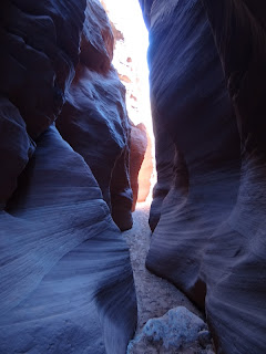
 |
| View at the confluence of Wire Pass and Buckskin Gulch |
After a warm fall a cold front hit the area right before our trip. We passed through the first snowstorm of the season in Flagstaff the day before and this morning it is so cold that our car is flashing alarms that the tires are underinflated. However the day promises to be beautiful with clear skies and temperatures rising rapidly.Our goal is
Wire Pass slot canyon at about 1 hour distance from Page so after a good breakfast we start driving. We have driven through the area before but are still impressed by the nice views from the road. Finally we arrive at the dirt road going towards the canyon and ultimately Arizona. We do not see anyone else on the dirt road but we meet a really bored deer that after checking us for some time finally decides to move on.
 |  |
| View from the road | Dirt road to parking area |
 |  |
| Deer trying to hide | Deer moving slowly |
The trailhead has quite a large parking area and to our surprise after the deserted road it is quite packed. We pay the entrance fee - at least there are no limited permits which seems to be common in the area - and start the hike. Initially the trail leads to a large wash and it doesn't appear to be at all spectacular.
 |  |
| Wire Pass Trailhead and fee station | Start of trail through large wash |
But then as we approach the entrance of the canyon the views change and there are great views of the cliffs in the area and some interesting rock formations near the trail.
 |  |
| Interesting formations near the trail | Impressive cliffs |
 |  |
| Lots of boulders near the trail | General view of the area |
And then suddenly we are in the slot canyon and it is quite impressive. And as we move through it it gets narrower and higher and soon enough we hit the first major obstruction as a boulder is wedged in the canyon and we have to carefully jump over it. Of course this is the place that we meet another person who at least eases our fears that further down the canyon is in worse shape by mentioning that this is the toughest place that he encountered.
 |  |
| Slot canyon is starting | This is not yet narrow |
 |  |
| This is narrower | And this is blocked |
A couple of times it feels that the narrow part is ending as we exit in a larger area but almost immediately we plunge again in another narrow and twisty segment.
 |  |
| It is just a little bit claustrophobic | Is that the exit? |
 |  |
| One of the larger sections of the slot canyon | Another narrow sections starts ahead |
The colors of the canyon change constantly and when the sun falls just right it looks almost like it is on fire. We stop constantly taking pictures and simply enjoying this marvel of nature.
 |  |
| Another obstacle in the canyon | End of the Wire Pass canyon |
In addition to the obvious scenic beauty the canyon also has multiple petroglyph panels especially at the confluence with Buckskin Canyon and quite a few fossils in the rocks along the way if you look carefully enough.
 |  |
| Petroglyphs near the confluence of Wire Pass and Buckskin | Fossils are abundant if you look at the rocks |
After arriving at the intersection with Buckskin Gulch we try to follow it downstream but are stopped relatively soon by a few waterholes that block our progress. We try also going upstream and it is again impressive but after about 1/2 mile we have to return to get back to our car in time. Returning to Wire Pass Canyon we notice lots of stones embedded in the canyon wall and rocks along the way which look quite interesting.
 |  |
| Interesting phenomenon of sinking stones | Another embedded stone |
Going back in we think we know what to expect but the canyon still is interesting and keeps surprising and impressing us. The sun is falling and this makes certain areas darker but others are burning red and beautiful.
 |  |
| Going back in | Mix of sandstone with sand |
 |  |
| Sun falling just right | Interesting rock formations |
The next section is the most impressive in the afternoon sign with the canyon walls a deep red that almost looks unreal. It is a beautiful sight that we take in for some time before moving on.
 |  |
| Entering the red canyon | Colors coming back were different than when going in |
Even after exiting the slot canyon the views are much better in the afternoon sun with almost everything looking different and much more vivid. We see a few wave like formations not as impressive as the major one nearby but at least they can be seen without an additional permit.
 |  |
| Almost out of the canyon | "Wave" like formations |
As we return to the paved road there is still time for a short side trip in a different type of canyon just off the main road. The canyon is shallower but it is wilder with more obstructions. The rock walls also look different and there are lichen on the rocks which we hadn't seen in Wire Pass canyon.
 |  |
| Glad they didn't fall now | Wash through the canyon |
 |  |
| Rock detail | Lichen on the stones |
We even find a few geodes embedded in the canyon wall and signs of rock hounds searching for geodes in the larger area. There are interesting holes in the wall creating small caves and tunnels and are interesting to investigate. However as darkness falls it gets colder and colder so we retreat back to the car and drive back to Page and the warmth of our hotel room.
 |  |
| General view of the canyon | Geode in the wall |
 |
| Beehives - panoramic view |
Before returning the area we want to explore two more areas around Page, one named by us "The Beehives" is little known and visited while the second one, the Colorado
Horseshoe Bend. is well known and quite visited. First we start towards "The Beehives" just across the dam from Page and the first public dirt road on the left. We leave the car on the dirt road and start exploring and almost immediately discover interesting hoodoos and rock formations.
 |  |
| First view of bee hives area | View of the area |
 |  |
| Individual rock formation | Another one of the pylon rock formations |
The more we explore the more interesting the area becomes. You can climb on some hoodoos and in other places you can discover hidden valleys, tortuous stone formations and mushroom like rocks.
 |  |
| Weird rock formations | Passing between the lonely sentinels |
 |  |
| Interesting formations are everywhere | Plateau with some formations |
Before we return to the car we decide to detour to another rocky area and it is also quite interesting even though the stones are less colorful. Instead it has more hidden waterholes and you can walk on the crest between them for great views. After exploring for some time we return to the car and drive towards the Horseshoe Bend Overlook.
 |  |
| Looks like waterholes | View from top |
The Horseshoe Bend parking lot is quite full and a good proportion of visitors are foreign which is a good indication of the popularity of this viewpoints. There is a 3/4 mi walk to the overlook which might be hard to do during the summer especially as the trail is sandy and goes uphill and then downhill a small hill. However when you get to the viewpoint the views are spectacular and unusually there are no guardrails or any type of protection to impede photo taking. Of course that means you have to be extra careful where you step as it is a long long way down :).
 |  |
| Horseshoe Bend interpretative panel | Large trail to the bend |
 |  |
| First view of the bend | Full bend is visible |
There are quite a few people taking pictures but they are spread out along the rim and it is relatively easy to find a more quiet spot for picture taking. Boats pass often through the canyon and give you a good idea how far the bottom is as they appear to be really small.
 |  |
| Lots of people are at the viewpoint | No one in this direction though |
 |  |
| Distance to the bottom is impressive and scary | Boats were common through the gorge |
We walk along the rim for a bit and find quite a few spectacular formations near the edge but of course we are always drawn back to the rim to view the impressive gorge.
 |  |
| Rock formations in the area | Pancake like rock formation |
Another thing that appears to be common in the area are the rabbits. They are almost everywhere and seem to be mostly used with the humans or at least they expect us not to see them as they stand in different positions near the rocks.
 |  |
| Rabbit in a shelter | Close up of rabbit |
 |  |
| Another rabbit in the open | Close up of "savant" rabbit |
As we return back to the overlook we walk a bit further from the edge and are surprised by the number of hoodoos that we find in such a short distance. There are also a few nice "Wave"-like areas that we explore before we decide to go back to the rim for a final look at the river and the gorge.
 |  |
| Rock formations in the area are impressive | Close up of a formation |
 |  |
| Colorado River Gorge | Very little vegetation survives in this landscape |
On the return trip through the Flagstaff area we exit close to the highest point on the highway to see the impact of the snowstorm. The dirt road is mostly clear but there is a lot of snow on the side of the road - the first snow that we touch this winter as we have to exit to walk a bit through it. After that it is straight back to Phoenix already planning the next trip to this great area with lots of slot canyons and weird rock formations.
 |  |
| Snow on the ground from the snowstorm | Roads are still open |


No comments:
Post a Comment