 |
| Butler Wash Ruins |
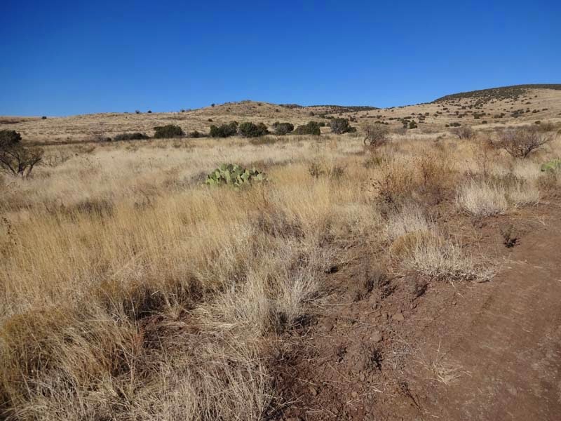
In this Thanksgiving trip we want to explore an area of southeast Utah in which we have been multiple times but we always find something new to see and do. The first day however is a long drive from Phoenix to Monticello with a few stops on the way to stretch our legs before we reach the Navajo Reservation where it is much more difficult to stop.
 |  |
| Exploring an Arizona side road | Typical landscape |
 |  |
| Climbing the hill | Close to the top |
The motel is typical for the area but the room is heated (which is good given that there is snow outside) and large which is what we needed. After eating an in room dinner from our provisions we go to sleep as the next day is the first full day of visiting.
 |  |
| Our motel - snow already on the ground | Our room |
In the morning after a short breakfast we start on our way to our first point of interest the Butler Wash Ruins. We didn't expect the snow to come this early but still most roads are clear even though the mountains are covered in snow.
 |  |
| Snow on the mountains | Close up of mountain |
 |  |
| Exiting near Recapture Reservoir | Farmhouse near Recapture Reservoir |
Butler Wash Ruins trailhead is clearly marked from the main paved road and it has a large parking area which is quite empty even this weekend. The trail is clearly marked with cairns which is good especially when it goes over a rock shelf where it would be almost impossible to follow otherwise. We soon have a first view of the alcove and then we arrive at the ruin viewpoint.
 |  |
| Going towards Butler Wash Ruins | Trail can be hard to follow |
 |  |
| A bit otherworldly | First view of the ruin's alcove |
The ruin is on the other side of the wash from the viewpoint and it looks impressive enough to be worth the short hike to it. You cannot reach it physically so we take as many photos as we can from this side using zoom as much as we can before returning back to the car.
 |  |
| Can you see the ruins? | Here they are |
 |  |
| Close up of ruins | Another alcove with ruins |
Next we go to the Arch Wash Ruins that are accessed from the Comb Wash Road. There are multiple ruins here and three arches but we have time only for the first ruin especially because the river is running high and it is difficult to pass.
 |  |
| Comb Wash Road | Somewhere there are the ruins |
 |  |
| Where are they? | Found them - Arch Wash Ruins |
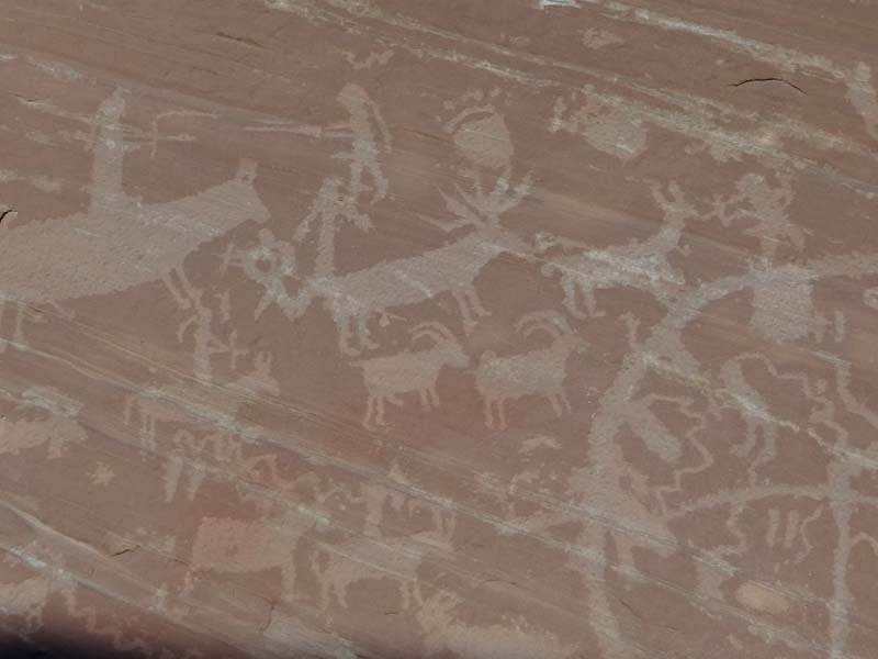
There are quite a few petroglyphs here, in fact the whole area is full of them as we have seen in this trip and others we have made. These ones are not that impressive but they are the first ones we see on this trip so that makes them special.
 |  |
| Typical petroglyph | A bit weirder |
 |  |
| Overview of petroglyphs | This type we have seen also in the Moab area |
We look around in the ruins for a bit, there are walls that are still standing likely stabilized by the BLM and the ruins are relatively small but the hike was short enough to make it worthwhile.
 |  |
| Closer to the ruins | Entrance to the ruins |
 |  |
| Close up of ruin | Some walls are still standing |
This is not the only attraction here - we climb on the canyon rim next for some great views of the surrounding hills and Comb Ridge which is broken in two by the main road snaking through it.
 |  |
| View from canyon rim | Water had impact even here |
 |  |
| Looking back at the Comb Ridge | Road is cutting straight through it |
From above we can see again the ruins - look different and well preserved from above or maybe it is a different set of ruins as there are many sites in the wash.
 |  |
| Ruins in the canyon | Another ruin |
The major attraction for us here on top is Walnut Knob - a huge boulder full of petroglyphs. Here there are a lot of amazing ones of herds of deer and alien looking humans so it is worth the short climb for us.
 |  |
| Walnut Knob - Petroglyph Rock | Weird style petroglyphs |
 |  |
| A better panel of petroglyphs | So many deer |
 |  |
| Is that an alien representation? | Certainly looks alien |
We can also see the river from here that we chickened out on crossing with our car and also on foot - we do not regret it as it looks quite wild.
 |  |
| River that we crossed | Rare moss |
Before returning to the accomodation we stop at the viewpoint on Comb Ridge for expansive views and even some birds that seem to enjoy the view as much as us. After this it is back to the hotel for another canned dinner before going to sleep.
 |  |
| View from Comb Ridge | Curious bird |
This morning as we wake up we notice there was some overnight snowfall, not a lot just enough to make us careful where we are going on dirt roads that look good but might be muddy and bog us down.
 |  |
| Overnight snow | Road to our goal |
Our first goal for the day is Cave Canyon Towers Ruin which is near the Arch Canyon Ruin we saw the day before but on the south side of the road. We park soon after the exit the highway as the road looks quite 4x4ish and walk the short distance to the towers. It is cold outside but there are a few attractions on the way that distract us including what looks like an old grave and a few side canyons.
 |  |
| Old grave? | Small pool |
 |  |
| Our trail | Do we have to pass it? |
The towers are surprisingly well preserved and are the only well known ones in this area - we have seen the ones in Howenveep NM but those are farther to the east. There are a few of them located on the canyon's edge and we enjoy walking around and exploring them.
 |  |
| Very cool canyon | This is our goal |
 |  |
| Close up of Cave Canyon Tower | Is this a door or window? |
 |  |
| Looking inside | Ruined area |
From the rim we can also see a few cliff dwelling but they look small and we do not see any other signs of a large Anasazi village (which doesn't mean of course they are not somewhere hidden:)).
 |  |
| Ruin at the bottom | Another of the many ruins |
We return to the car and continue towards the next attraction, the Valley of the Gods. As the road snakes through the area it seems to climb and there is more and more snow on the roads. We stop to take a few pictures and also are forced to wait on the main road as a large number of cows are using the cleaned road to walk towards wherever cows in that region walk to.
 |  |
| Snow has really fallen overnight | Cows on the highway |
 |  |
| Walking through the snow | Ice constructs on the tree |
Before the Valley of the Gods we have to descend the Moki Dugway. We have a pamphlet describing it but we are not sure what exactly is so special about it. It is a 3 mile stretch of road where our paved road becomes dirt and descends precipituously from Cedar Mesa to the Valley of the Gods. We don't know but it has been featured on Hell Roads especially when it is snowing. This time not knowing means no worrying as the road seems quite easy to us and we cannot see the famed drop offs due to the fog.
 |  |
| Moki Dugway | Glad the road is not this one |
Right after arriving at the bottom we exit the main highway and enter the Valley of the Gods loop. There is no snow at this altitude but the fog persists given the well known named formations in the Valley of the Gods a spooky appearance.
 |  |
| Valley of the Gods | Close up of "Lady in the bathtub" |
 |  |
| The "Sitting Hen" | So many interesting mesas |
The road snakes through the formations with a new view almost any minute. We stop here and there to take pictures of the impressive formations as we try to match them with our BLM pamphlet.
 |  |
| Enoying the view | Fog is still descending |
 |  |
| Another interesting mesa | View from the distance |
It is surprising how this area is not as well known as Monument Valley which sits on Navajo land and is not free to enter while here you can enter freely and walk as much as you want. You can even meet cows (they are everywhere on this trip) which this time are not at all interested in us.
 |  |
| Castle Butte | How are there so many formations here? |
 |  |
| Still foggy | Otheworldly view |
 |  |
| Longhorn cow | These cows are not interested in us |
As we still have time we decide to take a longer hike towards the last major formation of the loop, Seven Sailors. We enjoy the hike especially as we pass a small wash with trees where there are quite a few birds and where we sit down and relax for a while before returning to the car.
 |  |
| Let's walk to the "Seven Sailors" | We are there |
 |  |
| Rare trees | Bird resting |
We try to stop one more time on Lower Butler Wash Road for a view of some of the ruins close to the dirt road but it is getting dark so we decide to come back the next day during the day and explore the area more fully.
 |  |
| Lower Butler Wash Road | Ruins in the distance |
Also we are getting hungry and are unsure which restaurants are open on Thanksgiving weekend. Fortunately we find one open in our area and eat some typical food, chicken fried steak and a real steak both acceptably good, before returning to the motel and retiring for the night.
 |  |
| Chicken fried dinner | And a steak |
 |
| Goosenecks State Reserve |
In the morning we are surprised to see that it snowed again and this time it covered much of the ground. It even brought some deer into the city to eat from the gardens and we walk around a bit to enjoy the snow before leaving hopefully to less snowy areas.
 |  |
| It really snowed overnight - again | Winter wonderland |
 |  |
| Always have to be careful about deer | Side roads - not inviting |
We stop first at the Nations of the Four Corners Cultural Center in Blanding which we find soon is closed so we continue on our way.
 |  |
| Blanding - Nations of the Four Corners Cultural Center | This is the entrance - it is closed though |
As we descend with the highway the snow disappears and we take a few short exploratory side trips down some dirt roads. Again we encounter cows and they are again non interested and non aggresive.
 |  |
| No more snow - but there are lots of cows | At least they are not interested in us |
 |  |
| Another side road | Going forever |
Next stop is the town of Bluff or more specifically the Bluff Fort ruins. There is even a visitor center (closed today of course) but at least the ruins are free to enter so we walk a bit around exploring the reconstructed buildings.
 |  |
| Bluff Fort Visitor Center | Sculpture in the fort area |
 |  |
| Fort ruins | Reconstructed buildings |
You can look inside a few of them (through the windows) and they seem to be furnished so if they would be open it would be interesting to take a closer look. Everywhere there seem to be rabbits that luckily do not pay us any attention so we can stay and watch them for a while.
 |  |
| Historic building | The inn..or it looks like it:) |
 |  |
| Settler wagon | You can't see me |
Not far from Bluff we stop at Sand Island campground - not for the campground but for the panels of petroglyphs. The major one is well marked and has some nice petroglyphs of deer, "aliens" and geometric motifs right next to the campground road.
 |  |
| Sand Island Petroglyph Panel | Are they ancient or new? |
 |  |
| Deer petroglyphs are old - probably | Close up |
 |  |
| Really close :) | Another alien like representation |
But after this we decide to explore the area a bit more and continue along the San Juan River in the other direction from the campground. There are cliffs here also and we decide to explore them and soon we notice petroglyphs on them also.
 |  |
| San Juan River | No wading today |
 |  |
| Side canyon | Trail |
These petroglyphs are more spread out and less concentrated and some of them seem to be contemporary but still there are many interesting ones that keep as interested until we get to the end of the cliffs and then it is time to retrace our steps back to the car.
 |  |
| Trail near the petroglyph wall | Weirder panel |
 |  |
| This looks more modern | No comment |
 |  |
| Panel in a side canyon | Almost modern |
The previous day our attempt to go down Lower Butler Wash was thwarted by darkness but today we decide to follow the trail that we noticed the previous day and see where it goes. We assume it is the ruins however while it descends it doesn't seem to descend enough so we decide that we found the trail to the Wolfman petroglyph panel that we didn't expect to see this time.
 |  |
| Lower Butler Wash view | View of ruin in the distance |
 |  |
| Trail to the ruins | Ruins in the distance |
The trail is a shelf trail but safe most of the time with some nice views of the canyon and the ruins on the other side. It is also relatively short and soon we are at the petroglyphs.
 |  |
| This is our goal | That is where we are coming from |
 |  |
| Water is available close by | Careful where you step |
These petroglyphs are likely the best we have seen on this trip and the "Wolfman" is quite interesting. We are not sure if that is really why they were named that way but why not imagine it:)?
 |  |
| Some of the better petroglyphs | Interesting and unusual |
 |  |
| What is that bird doing? And why do people shoot at it? | Some really don't understand what protection means |
 |  |
| Weird petroglyph | A squid here? |
We return back to the car afterwards and are surprised how bad the trail can look superficially - it is quite good and safe actually.
 |  |
| The trail can look scary | You must pass through here |
After leaving Butler Wash there is still time in the day so we decide to take a detour to Gooseneck State Park - it protects an area where the San Juan river meanders in multiple loops creating a very special view. It is windy and cold however we brave the elements to take a few pictures before returning to the car to return to the main road.
 |  |
| Where is the view? | Is this it? |
 |  |
| Goosenecks View | Impressive San Juan River view |
We stop for one more hike on our return trip near Mexican Hat. In fact we stop to hike to the Mexican Hat formation or at least close to it. It is actually an only huge toadstool but seen from some angles it might look like a sombrero I guess.
 |  |
| Walking towards the Mexican Hat | Nice views |
 |  |
| Mexican Hat formation | Another view of Mexican Hat |
Last stop of the day is when we arrive in Monument Valley. We did not plan to stop but the view of the formations in the fog is otherworldly so we have to stop to take pictures and just simply enjoy the view. After this it is getting dark and we are on the Navajo Reservation so we continue without stopping to Phoenix after this short but very active trip.
 |  |
| Monument Valley in the fog | You cannot see the formations |
 |  |
| Very spooky | Snow and fog |
No comments:
Post a Comment