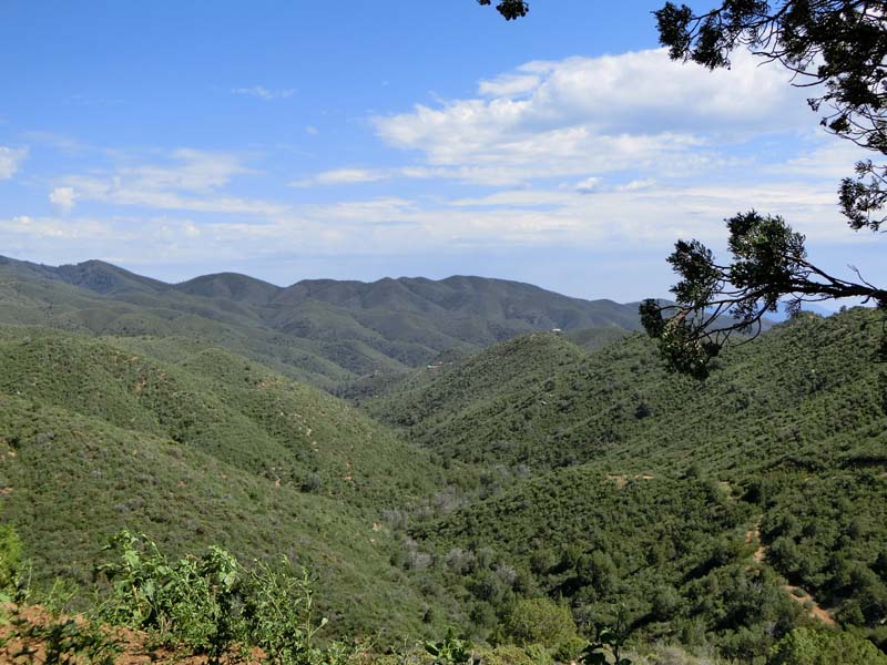
On the 4th of July weekend we decide to drive towards Prescott and hike a trail in the mountains near Prescott. It is a relatively colder day so we hope that even though it is lower altitude we can actually hike without being uncomfortable during the hike. Unfortunately as we leave Phoenix we enter into a long traffic backup on interstate I17 the main route to Phoenix so we decide to take the long way around through Wickenburg and then route 89. It is actually an interesting road that we have taken only once before that climbs quite dramatically to the juniper area around Prescott. We decide to stop on the way to explore a side road for a short while and also to find out how hot it is outside. The dirt road descends slowly and has some great views but it really is hot so soon we decide to turn around.
 |  |
| Valley View | Forested area |
 |  |
| Going down on a side road | Mining remants |
Right at the turnaround point we find what we think is an abandoned mining site with concrete foundations and lots of metal artifacts strewn around so we explore the area a bit more before turning around and returning to the car.
 |  |
| Quite a few foundations | Examing the foundation |
 |  |
| Debris from mining | Close up of debris |
Due to the change in the route we arrive much later in Prescott than we hoped so we change our plans also. We decide first to stop at the downtown celebrations where there is also an art festival. It is quite a large one right in the center square around the courthouse and we even find something to buy for our house - a beautiful pressed flowers artwork.
 |  |
| Prescott Art Festival | Everything is decorated |
 |  |
| Prescott courthouse | Another impressive building |
In the remaining couple hours we go into the cooler mountains south of Prescott on a short trail that we know leads to a small stream after a 1/2 mile hike. The hike is nice with no one else around this late in the day.
 |  |
| Trail near Prescott | Leveling a bit |
 |  |
| Wild forest | There are some clouds |
This leads to a few animal sightings including rabbits and snakes - it seems this is the year of the snakes for us.
 |  |
| What is that? | Cottontail rabbit |
 |  |
| Really? Another one? | Yes another snake |
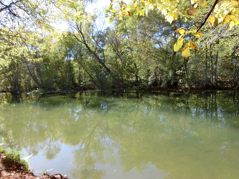
We arrive at the creek and enjoy it for a while before we see a thunderstorm coming and return fast to the car entering it just as it really starts raining. At least we escaped the stress of lightning as during the last meters it was a real lightshow. Overall it was a fun day even though it didn't go exactly as planned.
 |  |
| Riparian area - inviting | Great snack spot near river |
This weekend we have one more day out planned - going out with friends to see the fireworks in downtown Phoenix. We are suprised at the number of people - it is really difficult to find a parking spot but we manage in the end and join the throngs of people entering Steele Indian School Park. The place that jumps out first at us is the old car exhibit on the lawn of the park - the cars are quite interesting and can be studied both inside and outside. There is also a place where a jet of water is sprayed over an area and children and some adults jump around to cool themselves - it is still quite hot even this late in the day.
 |  |
| July 4th car show | Very popular |
 |  |
| Show is on park lawn | Playing in the water |
The fireworks are starting soon after we settle in a place and they are quite long and interesting and we enjoy them for some time before leaving to ensure that we we get to our car before the big exodus begins when the fireworks end.
 |  |
| Waiting for the fireworks | Here they are |
Today we are going to the Mogollon Rim specifically the Willow Springs Lake area. The trail that we intend to do is a loop trail that goes through the forest and then returns near the lake back to the car.
 |  |
| Start of trail | Forest view |
Relatively soon after we start on the trail we notice more and more mushrooms and then we see that some of them are chanterelles one of our preferred edible mushrooms. We collect a few for a later dinner (they are yummy) before continuing on the trail - always keeping an eye out for more chanterelles.
 |  |
| Chanterelle - edible | Our harvest |
 |  |
| Might also be edible | This is weird |
The trail is mostly level and on forest roads with a few rare trail signs but it is difficult to get lost. However as the weather starts to turn towards rain we decide to cut a bit of the loop through the forest - it is no shortcut in the end because we find more chanterelles and have to stop to collect them:).
 |  |
| Rare trail sign | Lake near the road/trail |
We pass a few ponds on the way some more scenic than the others. Unfortunately there are no birds but there are quite a few insects mosquitoes included.
 |  |
| Quite big | Flowers near lake |
 |  |
| Quiet pond | Dragonfly that followed us |
As we arrive at the car it starts to rain more seriously but we get in time inside and even witness a very cool rainbow right over our car.
 |  |
| After rain comes the rainbow | Closeup of rainbow |
Returning through Payson we decide to stop and eat at a Thai restaurant that we eyed a few times hungrily. The food is good and we decide to stop here again if we are hungry and are passing through at a reasonable hour (not often).
 |  |
| Dinner at Thai restaurant | More Thai looking |
After the rain a week ago we decide to try again the same area more or less - this time below route 260 instead of above but still very close. And the weather is not much better with a threat of rain throughout the day. All this rain of course has helped a lot the mushroom growth and they are everywhere but unfortunately no chanterelles.
 |  |
| Somebody ate this one | No one eats this one |
We park along the Mertzville road and walk down it for some time until we arrive at the Rim - the view is great as usual in an area that we usually don't see. There are a few buildings that we cannot identify and we assume are a ranch and some we can - it is a fish hatchery right below the Rim.
 |  |
| Close to the edge | Over the edge view of Canyon Creek Hatchery |
 |  |
| Expansive views | Probably a ranch |
 |  |
| Another view from the rim | Great spot for a snack |
Returning we are happy that we escaped most of the rain and even see a beautiful sunset due to the clouds the sky looks like it caught fire. We stop to enjoy it and then it is time to go back to Phoenix.
 |  |
| Can it get more redder? | Oh yes! |
Today we are a bit unsure where to go as the weather can make multiple locations feasible. We try first somewhere close to Phoenix - Table Mesa Road and go up a road that we always wanted to check. WE arrive at an interesting looking sign that asks for a permit but with no info how to get one so we decide not to enter it. So we return to the Black Canyon Trailhead which is on the same road and try the same trail that we tried a few more times - going south from the trailhead basically. Again there is a lot of shooting and as we hear bullets whizzing over us (even though it is forbidden to shoot towards the trail) we decide to bail out and return through a wash that will give us some cover.
 |  |
| End of the road - for us | Not really enforced or respected |
 |  |
| Mangled parts inside the wash | Typical view near the road |
The wash is surprisingly interesting with a few oases including one with a palm, we enjoy the walk back off trail more the on trail hike initially and we feel also safer.
 |  |
| Large wash | A more interesting narrow canyon |
 |  |
| Palm in canyon - rare and exciting | Very wild area |
As it is also quite hot we decide to move a bit higher up and to try another trail descending into Rattlesnake Canyon that we wanted to check for some time. We park the car and walk along the overgrown road towards the canyon with no idea regarding what is expecting us - everything is flat and quiet and we enjoy the walk.
 |  |
| On the way to Rattlesnake canyon | Pinyon juniper forest |
 |  |
| The canyon in the distance | Flowers on the rim |
And suddenly the road arrives at the canyon, it is quite sudden and impressive as we see the chasm into which we intend to descend. The road ends at the rim and from here a trail descends into the canyon. The trail is in a better shape than we expected and we can follow it easily even if it is overgrown. At the bottom we understand why it is so well maintained - there is a gauging station at the bottom which seems abandoned now.
 |  |
| First view of Rattlesnake Canyon | Going down - looking up |
 |  |
| Almost at the bottom | Gauging station at the bottom |
We walk around the canyon floor a bit, on one side is a dry waterfall while in the other direction it is overgrown. We enjoy the beautiful mosses on the ground before climbing back up so we arrive before it gets completely dark.
 |  |
| Dry waterfall blocks our way | Small puddle at the bottom |
 |  |
| Moss on the stones | Back at the top |
Back at the Rim we watch the beautiful sunset before walking back to our car in the falling darkness. Overall the canyon was quite exciting and it is surprising how deserted it is so close to a major interstate.
 |  |
| Sunset over Rattlesnake Canyon | Beautiful sunset |
This weekend we do a longer two day trip with an overnight in Williams. In fact the overnight is the highlight as we plan to stay at an historic hotel built in 1891 on the main street in Williams. The hotel is quite interesting with lots of knick knacks in the common rooms while the hotel room even has a kitchenette attached.
 |  |
| Our hotel in a historic building | Close up of hotel |
 |  |
| Hotel room | Our kitchen |
However today we don't plan to eat from our provisions and decide to go outside and find a restaurant. We find one quite close which seems good enough and we eat some steak and chicken fired steak which are acceptable but now we are too full.
 |  |
| Chicken fried steak | And a steak |
Therefore we decide to try a short hike near Williams basically to climb a small hill before sunset. It is a nice hike off trail and we enjoy the beautiful sunset before returning to Williams. In the evening there is an art hop in Williams and we walk around in the different stores looking at the art exhibits. While some are interesting it is smaller than the one in Jerome and soon we are done and return to the hotel room for the night.
 |  |
| Interesting tree while climbing | View of Williams from above |
 |  |
| Sunset from the top | Beautiful clouds |
In the morning we walk a bit around through the downtown area and decide to eat at the Red Garter Inn one of the many bordellos (now a hotel/restaurant) during the wild days of Williams. It is difficult to find a place but the food is good and we are filled for the day.
 |  |
| Restaurant from previous day | Red Garter Inn - former bordello |
 |  |
| Interesting ATVs | Old gas pumps |
We start on the way back to Phoenix but we take a more circuitous route going first towards the Grand Canyon on route 64 and returning on route 180 where we have a few stops planned. At the intersection between the two highways is an airplane museum that we plan to visit sometime but today we are in a hurry so we take pictures just from the outside before moving on.
 |  |
| Planes of Fame Air Museum | Another interesting plane |
We first stop to hike the Red Mountain trail a 3 mile roundtrip hike that is relatively easy but somehow we never got here to hike it. It starts easy enough on a flat terrain through the juniper forest with some nice views of the surrounding mountains.
 |  |
| Red Mountain trail info | Start of trail with Red Mountain in background |
 |  |
| Mt Humphrey in the distance | Beautiful area |
The trail continues through a wash for a while where you can find if you are careful "fake" Apache tears - black small stones that look like obsidian.
 |  |
| Walking through a wash | Really? Trail is there? |
 |  |
| Tree bark | Another interesting tree bark |
Soon after further narrowing of the wash/trail we arrive at a stair and after climbing it we are in the amphitheater/former crater of the volcano that is the goal of the hike. There are some interesting slot canyons to explore and we start exploring them to see what we can find.
 |  |
| Trail becomes more interesting | Peaks near trail |
 |  |
| Canyon becomes narrow | Almost a slot canyon |
The amphitheater is comprised of predominantly red stone which is where the mountain's name is coming from - it is contrasting nicely vs the green pines and the blue sky. After some time exploring we have to return to the car as we still have one more goal for the day.
 |  |
| Canyon wall | Close up of canyon wall |
 |  |
| Rock wonderland | There were eagles and swallows on these rocks |
 |  |
| Different color of rocks | Still beautiful |
On the way to our next hike there are some great views from the car of the mountains and the fall colors - the area seems to be in the middle of fall color season.
 |  |
| Our next goal:) | Kendricks Mountain |
 |  |
| On the way to Abineau trailhead | Fall colors on Humphrey peak |
The next (and last) hike of the day is the Abineau-Bear Jaw Loop a 7 mile loop hike on the north side of Mount Humphrey. The trail climbs quite vigurously for a while through the pines and has some good views but we are looking for fall colors and there aren't many in this first stretch of the hike.
 |  |
| Loop trail start | Beautiful view |
 |  |
| Trail through forest | Fall colors are everywhere |
We shouldn't have worried though as there are more and more aspen as we climb and all of them are in fall colors and quite beautiful.
 |  |
| Very beautiful | Getting above the yellow |
 |  |
| Area is always great in the fall | Such a great mix |
At the highest point the trail follows an old closed road that goes level for some time through the aspen/pine forest. It is beautiful walking on the fallen leaves and being surrounded by the yellows of the aspens however unfortunately it is also quite cold at this altitude so we cannot stop for long to enjoy.
 |  |
| Aspens on the way | And their top |
 |  |
| Walking at the "top" of the trail | On the ground |
Soon we arrive at the descent part of the trail from which we get a view of the snow zone on Mt Humpreys - it is closer than we expected which might explain the cold. The descend goes fast as long as we have light and then using our flashlight a bit slower but still we are at our car at around 9 pm tired and ready to return to Phoenix after this nice trip.
 |  |
| Sun is setting | Moss near the trail |
 |  |
| There is still snow this high up | View of the valley - long descent in front of us |
Today we decide to do one last trip to the Mogollon Rim before the snow closes the roads. It is eerily quiet with barely any cars, very different from the hustle and bustle during the summer. We park the car at a side road and decide to walk to an overlook of the East Clear Creek, it is a short hike on a level road passing a waterhole with even some fall colors so we enjoy it a lot. The view from the overlook is good with the canyon having spots of color from the aspen and the creek flowing far below us.
 |  |
| Side road to canyon rim | Still some fall colors |
 |  |
| What is that in the distance? | A waterhole - no animals though |
 |  |
| Getting to the rim | Rim view |
The next stop is at the bottom at the canyon where we stop right after passing the bridge over the East Clear Creek. We walk a bit along the banks of the creek enjoying the first time we find the area free of anyone else. It is a great area and it is understandable it is so popular during the hotter months - but there is no longer trail here so we continue on to find a hike for the day.
 |  |
| Bridge over East Clear Creek | Bridge from side trail |
 |  |
| East Clear Creek | Nice cliffs |
 |  |
| And a beautiful creek | What an interesting mushroom |
We decide to hike on the U Bar Trail and we access it from an access point that is not an official trailhead but quite close to the trail. In fact descending from that point we arrive at an old cabin that is on the trail and is rumored to be Zane Grey's hunting cabin.
 |  |
| Cabin on U Bar Trail | Dane Cabin - author Zane Grey's hunting cabin? |
 |  |
| Inside the cabin | Only window still standing |
The walk through the forest is quite nice and we enjoy it a lot as the trail slowly descends through the forest towards a creek. There are still mushrooms however otherwise it is very quiet and we don't see even one elk during our hike.
 |  |
| U Bar Trail | Quiet forest |
 |  |
| This looks beautiful | Such colors |
WE cross the creek easily and continue on for the while but in the falling darkness we have to return back the same way we came and arrive at the car in the darkness and leave for home using the Mogollon Rim Road with no animal encounters this time.
 |  |
| Crossing the creek | Nice riparian area |
With the falling temperatures we decide to explore an area that we never have visited before - the Sycamore Canyon near Cottonwood. We plan to take the Parson Springs Trail and hike as far as we can before returning the same way we came. The drive to the canyon on dirt roads is long and the road almost dead ends there so we are surprised that there are quite a few cars parked there already. The views from the parking lot are already quite impressive with the view of the riparian area and the fall colors being breathtaking.
 |  |
| Sycamore Canyon - fall colors | Canyon walls |
 |  |
| Close up of valley | Lots of trees in fall colors |
Before descending we decide to eat lunch and are lucky to see the once per day Clarkdale-Perkinsville tourist train passing right in front of us - sometime we have to take it also.
 |  |
| Clarkdale-Perkinsville train | Rare passenger train |
But not today - we explore a bit more the rim noticing also a ruin at the bottom of the canyon before starting our descent on the official trail.
 |  |
| Another part of the valley | Ruin at the bottom |
The trail starts with a quick descent but afterwards is quite level for some time as it follows the creek. As it goes through the riparian area there is also lots of shade which helps with the sun and the heat.
 |  |
| Starting on the Parson Springs Trail | Getting closer to the trees |
 |  |
| River is quite wide | And not that shallow either |
After about 1 mile we arrive at a water crossing which is quite scenic, and unfortunately difficult for us due to the fact that we do not have the water shoes with us. In the end we find a place to cross jumping a few rocks and continue on as the canyon starts to narrow.
 |  |
| This is our crossing point | Water reflection |
 |  |
| Trail on the other side of the river | Beautiful canyon wall in afternoon sun |
 |  |
| Another crossing | View at turnaround point |
We climb a steep hill for a better look of the creek and some magnificent views - but certainly not a good jumping point into the river - it is quite far below.
 |  |
| View from the cliffs | Valley view |
 |  |
| The crossing is far below | Riparian area is in fall colors |
We start our return back to the car and pass safely the creek but we can't stop taking pictures so it is getting dark before we get back to the car. The hike at night is very enjoyable and soon we are at our car and we have the long (uneventful) drive back to Phoenix ahead of us after a relaxing day near the creek.
 |  |
| Crossing back | There is a hummingbird here - somewhere:) |
 |  |
| Another rock to climb | Trail passing near the rock |
Today we have time only for a short trip so we decide to access the Black Canyon Trail from a different access point and just explore the area below the rest stop and scenic view on I17. The area is very quiet except for a few cows and we discover a few mining shafts as we walk the many overgrown roads and trails in the area. Soon however we have to return back to the car and back to Phoenix to prepare for our Hawaii trip in a few days.
 |  |
| View from trail | Not in Sedona - still fun |
 |  |
| Flower near trail | Interesting moss |
Today we don't have in plan a trip outside Phoenix but actually we intend to visit Phoenix with family. We start with the Capitol area - in front of the Capital is the USS Arizona Memorial with a lot of symbolism and the some of the guns from the ship exhibited alongside the memorial.
 |  |
| USS Arizona Memorial | Guns from ship |
 |  |
| USS Arizona Anchor | Korean War Memorial |
It is not the only memorial however with a lot more of different size and shapes on both sides of the path that leads to the Capitol from the USS Arizona Memorial.
 |  |
| Gulf War Veterans Memorial | Arizona Confederate Troops Memorial |
 |  |
| Civilian Conservation Corps Memorial | Pioneer Women Memorial |
We cross the street in front of the capitol and after a look at the petrified wood and the copy of the Liberty Bell in front of the capitol we check whether it is possible to enter. We are surprised that the museum is open and is free so we decide to enter and visit it as we have a few free hours.
 |  |
| Arizona Capitol in the distance | Close up of capitol |
 |  |
| Copy of Liberty Bell in front | And some petrified wood |
The museums centers around the rotunda over four floors and we decide to take the elevator to the top and start from there descending towards the entrance.
 |  |
| Rotunda inside the capitol | Looking down the rotunda |
The most interesting area is the Legislative Chamber where the Constitutional Convention for Arizona was held. There are multiple informational panels and you can enter the chamber and walk through it which is quite fun - it looks more like a college or high school than a place where laws have been made.
 |  |
| Legislative Chamber | View form the balcony |
 |  |
| In the legislature | Constitutional convention was held here |
There are other rooms too with many memorabilia related to Arizona including guns, copper ore and petroglyphs. There is also an exhibit about the history of the seal of Arizona which is quite interesting seeing how it evolved over time depending on the predominant industry in the state.
 |  |
| Made of Lego blocks | Arizona petroglyphs |
 |  |
| Very important in Arizona | Freeport McMoran Gold & Copper Ore |
 |  |
| Old seal | New seal at the bottom of rotunda |
Another area is focused on voting and mining in the state with some cool examples of old voting machines (and old looking voting machines that are still used).
 |  |
| One of the many epoch rooms in the museum | Some even have people - fake ones |
 |  |
| Voting room exhibit | Voting machine |
The last area that we visit is the first floor with an exhibit related to the USS Arizona and Pearl Harbor. Interestingly they have some silverware from the ship that was salvaged - it is interesting as we didn't expect a military ship to carry silverware in battle.
 |  |
| USS Arizona model | Silverware from sunken ship |
After the museum we pass through the downtown area looking at the different high rises however all is quiet during this weekend and we soon get bored and decide to end the day in South Mountain Park.
 |  |
| Downtown Phoenix | Lots of banks |
 |  |
| Interesting building | Double towers - more or less |
We decide on a short and easy trail that loops next to the visitor center but has a few interesting things going for it including some petroglyphs to show to our relatives. We also see a flock of quail which is exciting especially seeing this many of them together.
 |  |
| South Mountain trail | Desert view |
 |  |
| And some mountains | A few petroglyphs |
Before returning home we make one more stop at the Scorpion Gulch Ruins which are always interesting to show to friends and family who are visiting us. After a brief exploration and tired after a long day outside we return home for the day.
 |  |
| Scorpion Gulch ruins | Inside the ruins |
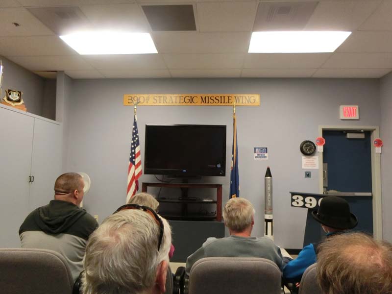
One of the things we always wanted in Arizona is the Titan Missile Museum near Tucson where you can visit a deactivated Titan nuclear missile. The visit is by tour only so we join a tour that starts with a short briefing before being given the option to go down by elevator (really slow) or stairs.
 |  |
| Strategic Missile Command Center briefing | Going towards the bunker |
 |  |
| Going down in style | Or by stairs |
We pass through the big solid doors protecting the inner area from an enemy attack (nuclear or otherwise) so a counterstrike can be guaranteed. Another interesting protective feature are the huge shocks that again were supposed to protect against earthquakes created by enemy nuclear strikes.
 |  |
| Really? | Entering the nuclear silo |
 |  |
| Long corridors | With shocks to survive nuclear earthquakes |
Next we enter the command center - which is built intentionally to be as resistant to EMP as possible including avoiding modern sensitive equipment. Here we receive a longer lecture about what the person on duty was supposed to do in case of a command to launch the rocket.
 |  |
| Missile command center description | So many people |
 |  |
| Only old time computers are used | Just in case |
Next on the tour is rocket, on the way we pass different artifacts of the times gone by and a few more huge shocks protecting the command center.
 |  |
| Uniforms for on duty personal | And hard hats |
 |  |
| Shock absorbers in control room | And everywhere else |
The missile is huge and it is difficult to take a picture of her that shows the full length and that gives an idea of the size. In fact these are the missiles that took humans to the moon so we should have expected it but we never stood that close to one before. Another lecture here explains how it was fueled and how that was the most dangerous part of the launching job.
 |  |
| This is the nuclear missile | It is huge - in fact it is the same rocket that propelled Apollo |
 |  |
| Gantries to service the rocket | And the fuel station |
On top we are allowed to wander around a bit examining the museum exhibits laying on top of the bunker. There is also a skylight allowing us to see the missile below which is again very impressive.
 |  |
| Walking top side | Top side security |
 |  |
| Fuel construct | Rocket engine |
 |  |
| Perimeter warning | Looking from above |
After the visit we go close by to a Chinese restaurant and eat an early dinner/late lunch before starting our way back to Phoenix.
 |  |
| Eggdrop soup | Lunch/dinner |
On the way we make one more stop in Tucson at the well known plane graveyard. There is also a museum here that we do not have time to visit today (it is also closed already) but we pass around the perimeter of the graveyard for some impressive views of the rows and rows of airplanes before returning back to the interstate and Phoenix.
 |  |
| Tucson plane graveyard | There are rows and rows of planes |
 |  |
| Close up of plane | Another plane in the graveyard |
With the year coming to a close we take our relatives to visit the ASU campus with a focus on the renowned meteorite collection. We start with a hearthy breakfast close by waiting for the museum to open before identifying where to park and walking to the museum.
 |  |
| Hearthy breakfast | Huge pancake |
As we enter the building we are immediately drawn to the astronomy exhibits with some nice replicas of spacecrafts and mars landers. However weirdly there are also some dinosaur eggs in the mix for some diversion we guess.
 |  |
| His brother is on Mars | Dinosaur eggs |
 |  |
| Moon landing diorama | Many different spaceship models |
Climbing the stairs we arrive at the meteorites collection which is divided in a few cases with explanations of the types of meteorites and where they were found across the world. There are also 2 fun dioramas of the best areas to find meteorites - the Antarctica and desert areas with little vegetation like Arizona.
 |  |
| Meteor Museum | Many meteorites |
 |  |
| Fun arctic meteorite diorama | And a desert one |
 |  |
| One of the bigger meteorites | They can be quite beautiful |
Before returning home we look also at a few labs which can be watched through huge windows (no one is inside during the holidays of course) and then at the interesting comparison of Grand Canyon with the largest Canyon on Mars (Grand Canyon is much much smaller).
 |  |
| Laboratory at ASU | Comparison of Grand Canyon with the biggest Mars canyon |
No comments:
Post a Comment