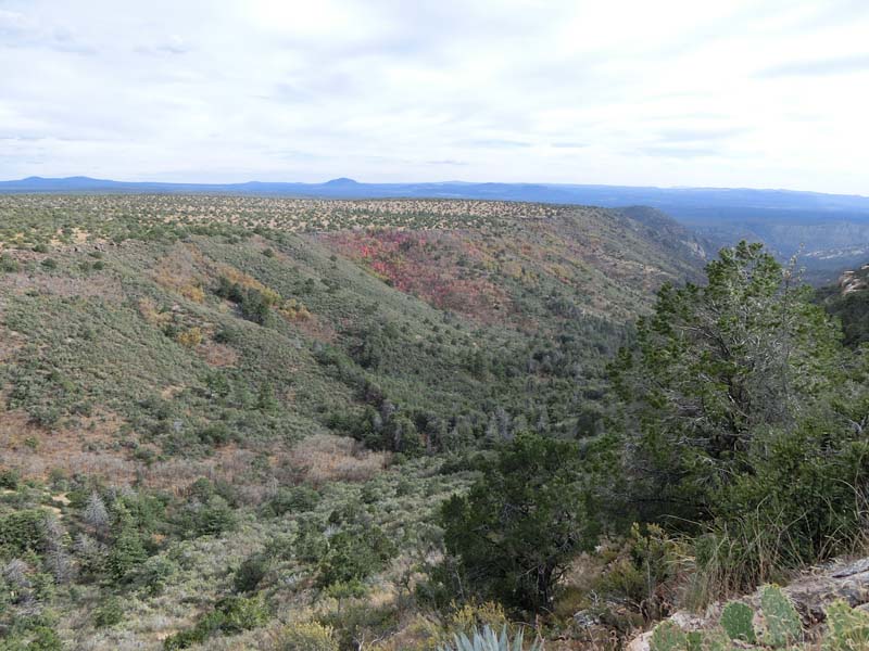
Today our plan is to go on the Milk Ranch Point which is part of the Mogollon Rim and visit a few overlooks on both sides of the rim and maybe do a bit more hiking on the Rim proper afterwards. This is the first time on the Rim proper this year and we are happy to start hiking as soon as possible so we park at the first side road and start hiking towards the rim and overlook. In this case the overlook is towards Pine Canyon that we saw and entered from the other side just a few weeks ago.
 |  |
| Road to viewpoint | Passing a waterhole |
 |  |
| Nice views into the Pine Canyon - from the other side | It is quite a long canyon |
Next we return to the car and go down the road a bit and walk to an overlook on the opposite side - the "peninsula" is quite narrow as we go towards the point. The walk is shorter this time and the views are different as we look down the Rim onto the villages below. Unfortunately we also see a summer storm approaching so we decide to go more inland where there is less chance of us getting hit by stray lightning because of the trees.
 |  |
| View from the other side | A storm is coming |
The trail we chose is a loop trail about 3 miles long and we don't know how long we can actually go on it due to the likely rain which starts immediately as we go out on the hike. But we persevere and it stops soon enough and after that it is a fun though wet hike through some interesting rock formations before returning back to the car and Phoenix.
 |  |
| Another trail/road into the woods | Rock formation in the woods |
Today we plan to explore the trails north of Munds Park - it starts on what looks more like a road and it is quite hot so the beginning is not that good but soon we enter the forest and it is much better and also clouds start rolling in hinding the sun making the weather more bearable. The clouds soon become rain clouds and are quite worrying so we decide to return back using a loop trail we found. The rain starts soon enough and we take out the ponchos and continue exploring the woods finding interesting trees and lots of mushrooms. We arrive at the car wet and dirty but overall we had a great time especially after the temperatures went down.
 |  |
| Starting on the trail | Trail or road? |
 |  |
| Into the forest | Where to go to escape the rain? |
 |  |
| Beautiful gnarled tree | Lobster mushrooms - we think |
We always fashioned us to be amateur mushroom gatherer - we know two varieties that are safe and have collected them both in Europe and USA. However here we have a chance to learn from the masters so we jump at it and join a two day course in mushroom hunting at Flagstaff Arboretum. In starts in the evening on Friday with a lecture and some tasting so we make our way up north after work and arrive just in time for the tasting - the mushrooms are unknown to us but quite good and used as filling for tacos. The subsequent seminar is also quite interesting with a description of the types of mushrooms and then going over some of the more common ones with samples - it is a bit overwhelming in fact even though we thing we have learned at least two more that are safe to eat.
 |  |
| Mushroom festival samples | And some food - from mushroom |
 |  |
| Mushroom explanation | Some are circulating on plates |
The next day we have to be early for a field trip so we decide to stay at a hotel in Flagstaff and then drive the short distance to the Nordic Center where the field trip is. As we arrive other people are gathering also and soon we are split in three teams each led by a specialist that will describe the mushrooms found and also as a bonus everything found by us that is edible we can take with us.
 |  |
| Everyone arriving for the field trip | This is the starting point |
 |  |
| People gathering | Describing the found mushrooms |
Unfortunately we find only inedible mushrooms but it is quite interesting how many types of mushrooms are and how many are giving an expert also trouble in identifying - many can be done only by spores which takes some time to collect.
 |  |
| Small slimy mushrooms | Very dainty one |
 |  |
| All the finds | A few edible also |
After the field trip we go on our own trip through the mountains and lo and behold between many mushrooms that we cannot identify we find a large cluster of one of our staples - we have food for tomorrow:).
 |  |
| Our find - not edible | But these are |
 |  |
| Walking the slopes | Some nice flowers |
In fact we are crossing the San Francisco mountains to the north on a new route which rattles us quite a bit but we succeed and exit at the other side on US 89 near Sunset NM which we intend to visit. We have a specific trail, Cinder Cone Trail, in mind to hike however a large group of scouts are just starting noisily out on the trail so we decide to explore a bit more for something more quiet. That is the Lava Flow Trail and we take the longer loop this time compared to the last time we were here with family and already from the beginning start passing some nice volcanic features like vents and lava tubes.
 |  |
| Sunset Crater NM | Collapsed lava tube - we think |
 |  |
| Loop trail in the NM | Vent near trail |
There is no one else on the trail which is nice however unfortunately you cannot explore the features closely - you are requested to stay on the trail and there is no entrance into the lava tubes, some are even closed with metal grills.
 |  |
| Gnarly tree | Weird flower |
 |  |
| View from trail | Collapsed small caldera |
 |  |
| Lava tube down there | Crater in the distance |
After exiting the National Monument however we stop and go exploring off trail a bit with some nice payoff of a cool fumarole which can be entered for a few meters to walk into the lava tube that created the fumarole - quite exciting.
 |  |
| Cool collapsed lava tube/fumarole | Inside it |
Last stop is at Doney picnic area where instead of the trail that goes up we walk on an abandoned road at the base for some nice views of the completely different vegetation in this area - it is plains as far as the eyes can see with no pines.
 |  |
| There is a trail to the top | We choose a side road |
 |  |
| No more pines here | But still volcanic |
On the way back we are famished so we stop at the Pita Jungle in Flagstaff the recharge and then even do our groceries at a nearby store - that is a win/win for the rest of the week:).
 |  |
| Pita Jungle soup | And gyro |
Today our plan is to go down the Chevelon Canyon using an old, possible abandoned trail we have targeted for some time however every time due to rain we had to turn back and do something else. This time there is no rain and we push the Jeep until the road doesn't seem to be drivable anymore where we park and have lunch before starting on the hike. Initially there are still some signs of the road however it soon ends at an overlook of the canyon that gives us an idea how much we have to descend.
 |  |
| Can you see the road/trail? | Maybe here there is a trace |
 |  |
| Long way to go down into the canyon | Water at the bottom |
The trail starts from here supposedly and we find it but it is very faint and it takes a lot of effort to follow it and even so we lose it a few times which is a pain especially during the descent which is steep and rocky - we are happy that we turned back previously this would have been painful if it would rain.
 |  |
| Descended a bit | Still a ways to go |
 |  |
| Our trail - really | Nice foliage near the trail |
As we arrive at the bottom we are really taken in by the scenery, it feels we have descended in a different world untouched by people - well except for the much better trail that follows the bottom of the canyon:). We decide to follow it and choose a direction more or less at random and the walk is quite enjoyable with lots of fall foliage but no water - at least in the beginning.
 |  |
| Finally down in the canyon | There is a better trail here |
 |  |
| No water here | Empty wash with beautiful folliage |
After about one mile suddenly water appears in the canyon - it goes from zero to a river/lake quite suddenly and the trail skirts the lake higher up with some great views of the yellow leaves reflected in the lake. Unfortunately it is getting late and we have to return but to do that we have to pass an unexpected tarantula on the trail - we decide to wait it out and after he passes we hurry to make the climb back to the rim before darkness and barely make it to the top before it gets dark. The rest of the hike is great at night especially on the road portion and it seems we arrive to soon at the car, overall it was a great outing in an area that seems to receive very few hikers.
 |  |
| Just in case you thought there was no water at all | Best part of the trail |
 |  |
| Yep - still in a canyon | Wildlife - especially tarantulas - have priority on trail |
Sedona is a beautiful area however it is very also very popular and the major trails can be very busy especially on the weekends. However there are still trails that are out of the way and where you can experience solitude and that are the trails that we want to explore. Today we are trying out the Munds Mountain Trail however from a slightly different start than the official one. The usual route starts from the Schnebly Hill Road before the Rim where you climb the rim and then enter the trail proper - we however decide to start from the same road but up top and use some abandoned roads to get to the starting point. The advantages are that of course you don't have to climb the rim and also you have the opportunity for some great views on the road to the trailhead.
 |  |
| Red rocks of Sedona | That is our goal |
Even more unexpected we find the ruins of an abandoned cabin on the way - the chimney is still standing and a few walls and it is fun to explore a bit while also enjoying all the fall colors on the rim.
 |  |
| Ruined cabin on the way | Preserved chimney |
 |  |
| Fall colors | Small patch of red |
From the cabin the road descends a bit through the forest and is covered by leaves and then suddenly we intersect the official trail and it is time to say goodbye to the road and start on the trail. While it is an official trail it is also a bit difficult to follow due to the leaves and the low number of people passing (we saw only 2 people the whole time from a distance).
 |  |
| Road covered in leaves | Start of official trail |
 |  |
| Rare red leaves in Arizona | Oak leaves on the ground |
The trail follows the Rim closely and from time to time you are close enough to get views of the valley full of red rocks and Sedona in the distance. The goal is to reach a saddle between the plateau we are on and Munds Mountain which is a separate mesa accesible from the main plateau only by the narrow saddle.
 |  |
| Sometimes we are close to the rim for great views | Getting closer |
 |  |
| Sedona is down there | These formations are mesmerizing |
The saddle straddles the Jacks Canyon where there is a major intersection of three trails (all of them part of the Sedona trail network and all of them not really popular) - the one we want is the Munds Mountain one but we also intend to explore the other two (one going down Jack Canyon, one climbing back to the main plateau) some other time.
 |  |
| Jacks Canyon | Foliage in Jacks Canyon |
 |  |
| Trail on the rim | And on Munds Mountain |
The climb back toward Munds Mountain is steep and the trail is difficult to follow but there are many different variants - somehow we make it to the top and are still on the trail which is again well defined on top. Here we wander around a bit enjoying the fall colors and the views and of course the solitude before starting on our return trip.
 |  |
| Lots of young trees - nice | Trail covered by foliage |
 |  |
| View from mesa | Airport in the distance |
As flat as the plateau is the descent is of course very steep (we knew that this time) however with experience it seems much shorter than going up and soon we are down catching glimpses of the rocks now illuminated by the setting sun.
 |  |
| Secluded trail | A bit of grassland |
 |  |
| Looking in Jacks Canyon | Red rocks during sunset |
The view is magnificent and we hurry to climb back on the main rim to find a better vantage point before the sun goes down completely and out of breath we arrive at a great spot where we take lots of pictures of both the sunset and red rocks reflecting the last rays of the sun. Of course when we leave it is almost dark so it is good that we enjoy hiking in the dark with our headlamps and after two more miles of rim walking we are back at our car after a great trip in the Sedona area (or more precisely above it:)).
 |  |
| We can't get a clean shot of the formations | Finally |
 |  |
| Beautiful sunset | Otherworldly |
This weekend we plan to explore the Payson area which sits at that inconvenient altitude that makes it too hot for summer and too cold for winter. But today it looks like a great day so off we go. Our first stop is Chaparral Ranch Trailhead a small trailhead that provides access to public land from a private community and as such it is hidden and minimalized in all official brochures and even when there parking is extremely limited.
 |  |
| Trailhead - big sign small parking lot | Trail is large |
One of our goals for this trail is an interesting abandoned underground bunker that we researched on the internet but it is still quite unknown. We are not sure if we are going to be able to find it but the trail takes us right to it and after a bit of searching we also find the entrance and of course we have to explore but first we have to wait out a few ATVers who arrive after us but enter directly in the bunker - they are quite fast though and soon we are alone again.
 |  |
| What is this? | Mysterious... |
 |  |
| Should we go down this way? | Probably better use this entramce |
Inside there are only a couple rooms and a skylight and even though we look carefully we cannot guess the reason this bunker was built there are many theories from nuclear shelter to seismographic station but everything is gone so we cannot really guess.
 |  |
| Bunker or seismographical station? | Looking from below |
 |  |
| One of the rooms that can be entered | Spooky slab |
The other goal is a small peak just off trail for the views and while the off trail climb is a bit steep it is also very fun and the views from the top or worth the small energy investment. After this we return back to the car to drive to the second trailhead we wanted to explore.
 |  |
| View from top of hill | Village in the distance |
The trail we want to check is the south part of the American Gulch Trail which is not yet connected to the north part. The parking area at the trailhead is quite large even though we are the only car in it. The trail starts climbing from the beginning and soon we have some great views of the trailhead and the houses surrounding it. After a steep climb we arrive at the top and from here the trail is more level passing some waterholes and then weaving through a few valley to another crest where it stops and this is our turnaround point as we return to the car in the falling darkness and then back to Phoenix after our short trip in this interesting area.
 |  |
| American Gulch Trail | View from saddle |
 |  |
| Easier trail on top | Small waterhole |
This Veterans Day we decide to go on an overnight trip to Prescott so we can have a more relaxed visit especially of Antique Row and of the trails in vicinity. But especially we want to visit the Heritage Park Zoo that we heard about but never visited. It is actually quite a small zoo mostly of rescued animals but it has also some interesting ones like bears and lynxes.
 |  |
| Welcome to Heritage Park Zoo | Thanksgiving is coming;) |
 |  |
| Waiting to be fed | Probably already fed |
They have quite a few coyotes, foxes and multiple antelopes all rescued or used to humans.
 |  |
| One of the coyotes | The most pampered coyote |
 |  |
| Two foxes | Two pronghorn antelopes |
Besides animals there is a large area dedicated to birds and another one to reptiles - some of them are quite interesting especially as we catch feeding time at the reptile house.
 |  |
| They really do exist:) | Walking around |
 |  |
| Domesticated kestrel | And one of the owls |
Last part we visit is the petting zoo section which does not appear to be visited that much - we decide not to pet but go to look at the llamas, goats and chicken from close by before leaving the zoo and driving towards the downtown area.
 |  |
| Petting zoo section | If you can catch them you can pet them |
Downtown we wander around looking at the different interesting art boutiques before passing through the central area to the Antique Row where we visit half of the antique shops and even buy a few things for our house as we cannot resist when we find some interesting stuff:).
 |  |
| Riverside walk | Sharlot Hall Museum |
 |  |
| Small nicely decorated shop | Cortez Street buildings |
Now it is late enough to go to check in and the room we receive is newly refurbished - maybe we are even the first people to stay here after the remodel. It has some interesting touches including the electric fireplace which is quite cool and is nice to have during the cold evening. The TV remote however is not working for the volume and after lot of trying with the manager and the motel handyman we find a may to adjust it manually - to compensate us for the trouble the hotel manager gives us a $20 certificate for breakfast at the nearby restaurant.
 |  |
| Small but nice room | TV with problems |
 |  |
| Not real but still cool idea | One of our purchases |
In the evening we go out to eat at a restaurant that we found online and the food is quite interesting (burger wih narrow!) and good and full we go to sleep for the night.
 |  |
| Burger with marrow | Osso bucco |
In the morning we decide to go to the breakfast place where we got the $20 discount which is in walking distance right next to the motel. The food is quite good and we are quite filled when we get out after our breakfast.
 |  |
| Eggs benedict | Is this breakfast or dinner? |
To walk off the extra pounds we take another stroll through the downtown area visiting the rest of the antique shops and buying a few more trinkets for our house before checking out of the hotel to drive towards our next destination, the Lynx Creek area for hiking.
 |  |
| Breakfast place | Our hotel |
 |  |
| Prescott Courthouse | Restaurant from previous day |
The first trail for today is the Lynx Creek Ruins Trail a short half mile trail to an overgrown ruin on National Forest land. To our surprise there is no one else around and the weather is great for hiking so we enjoy the views and the area and soon arrive at the viewing point on top of a small hill.
 |  |
| Lynx Creek Ruins Trail | More vegetation along the trail |
 |  |
| There is a fire in the distance | That is our goal |
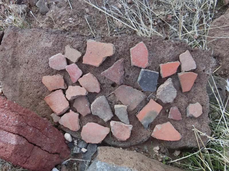
The ruin is looking more or less undisturbed and unexcavated and as all of this type of ruins little can be seen besides the rock walls and some pottery. It is a big contrast vs. the excavated ruins where the walls are clearly visible.
 |  |
| Close enough | These are the ruins |
 |  |
| You can barely see the walls | This is how the ruins look naturally |
After returning to the car we drive a bit farther up to a major trailhead from which multiple trails leave. We decide on a loop trail and start on the Salida Connection Trail which is more like an abandoned road that climbs sharply to a crest above the Salida Creek and then follows the crest before dropping back into the Creek where it meets the Salida Gulch Trail that we take back towards the parking lot. This trail is more trail like following the creek where from time to time we even see water which is exciting in Arizona:).
 |  |
| Salida Connection Trail #9263 | More like a road than a trail |
 |  |
| Getting more trail like | Return on Salida Gulch Trail #95 |
 |  |
| There is some water flowing | Close to the water |
However the highlight of the trail are the petroglyphs midway on the way back - there are not many of them but still it is always exciting to find them.
 |  |
| Petroglyph Rock | Quite a few |
 |  |
| The animal panel | Close up of some glyphs |
Towards the parking lot the trail passes through a marshland created by the creek - luckily there isn't enough water to make it very boggy but still we have to pick our way carefully until we get out of it and reach our car.
 |  |
| Walking near the creek | Rare green |
Returning we have quite a surprise as the exit is seemingly closed and we are a bit scared that we have to spend the night here until we read the sign that we can still exit even though the area is closed. Not sure how or why it is closed before even sunset and we were not even the last people out but we are happy it is not locked and soon are on our way to Phoenix after our relaxing weekend.
 |  |
| We are stuck!! | Phew:) |
One of the areas close the Phoenix that we have visited multiple times is Spur Cross Ranch using the multitude of trails that leave from the large parking lot. Today we plan a hike along Cave Creek and Cave Creek Trail exploring areas we have not visited before. The start of trail is through Spur Cross Ranch after paying entrance for the Preserve which is the only why to access this side of the National Forest. Today we have however a surprise - Cave Creek always flowing in our experience has disappeared which makes the usual water crossing that much more easier.
 |  |
| Spur Cross Trail | No water at all today - a real surprise |
 |  |
| Nice views in the wash | Leaving Spur Cross entering Tonto NF |
After exiting Spur Cross Ranch we are on National Forest land following old roads and new trails. We try to keep as close as possible to the wash enjoying the views - the fall (winter?) colors are everywhere and there is some nice mix of yellow leaves and saguaros which is a bit unusual of course given the different habitats they inhabit.
 |  |
| More trail like | Saguaros in the greenery |
 |  |
| Walking in the wash | Beautiful landscape |
Only once we deviate from the wash as the trail seems quite small and to disappear while a road goes up the hillside and we assume it goes around a blockage in the wash. The views are great however soon we become convinced that we took the wrong turn so we return and of course the trail in the wash was the right one - still we enjoyed the views of the foliage and even a palm tree from high above.
 |  |
| Fall colors in December | Close up of the trees in the wash |
 |  |
| Taking the trail above the wash - a mstake | Rare Arizona palm tree |
The next major attraction on the trail are a few black boulders full of petroglyphs. As usual we explore them as much as we can - some of the petroglyphs here are quite unusual so we enjoy this stop before continuing on.
 |  |
| Petroglyphs in the distance | Getting closer |
 |  |
| Some of the petroglyphs | Close up of a couple of them |
We are passing now an abandoned farmland as evidenced by the destroyed cars and remnants of buildings. Especially interesting is the overturned car forming a "bridge" over a small wash.
 |  |
| What is that in the distance | One way to cross the wash |
 |  |
| Abandoned coral | Ruins on the way |
As we arrive at the abandoned ranch we keep a close eye on the hillside as we know there is a trail going up to Cave Creek Trail but there is no clear description where it leaves. In fact it leaves right from the ranch site but the start is quite hidden - we feel like real explorers when entering a few bushes we find the trail which is surprisingly well defined afterwards climbing steeply the canyonside. The views are great and we even find a few petroglyphs near the trail - groovy.
 |  |
| Great views from trail | And a few petroglyphs to boot |
Just as we think we have missed Cave Creek Trail we intersect it and while we explore a bit farther we soon have to start on our return trip as it is late and supposedly Spur Cross closes at 8pm even though there is no way to really close the preserve. At least the moon is up which will help us while night hiking but before it gets dark we have one more attraction to visit - the Chalk Canyon Ruins. Again it is not clear where they are located but with some vague directions and a bit of luck we arrive at them before it gets too dark to examine this extended ruin.
 |  |
| Moon is helpful for night hiking | Nice view for a ruin |
 |  |
| Chalk Canyon Ruin | Unexcavated wall |
Most of the room are not excavated but the few that are are impressive showing up the height of the walls and the size of the major rooms - the rectangle room especially looks a lot larger than any we have seen before in these cliffside ruins.
 |  |
| Excavated wall - more impressive | Close up of wall |
 |  |
| Interesting oval room | Best preserved room |
 |  |
| Close up of room | What is this - a hearth? |
As usual we find a lot of pottery and a bit more unusual we also find a lot of panels full of petroglyph that we explore until it gets so dark that we have to return back to the main trail. From here it is a nice moonhike on Cave Creek Trail and then through Spur Cross back to our car. Overall we did over 16 miles on this beautiful day seeing some very nice countryside.
 |  |
| One of the many petroglyph rocks | Animal petroglyph |
 |  |
| Animal with pottery shards | Another set of pottery shards |


No comments:
Post a Comment