We haven't visited McDowell Mountain Regional Park for a while and today seems like a great day to rectify this. We stop at the visitor center and enter it to see the reptiles on display and buy a T-shirt on display before eating a quick lunch at the tables outside and then we are on our way.
 |  |
| McDowell Visitor Center | Pointing to nearby peaks |
We start on the Tortoise Trail that is connecting trail to the major trailhead parking lot. It is about an 0.5 mi flat hike through a relatively uninteresting terrain but it is also quite unused by other people which is a plus for us.
 |  |
| Starting on the trail | Really featureless trail |
 |  |
| Scenic tree near the trail | A bit more greenery |
We then cross the huge official parking lot where some people seem to spend their whole day just running around the restroom and grilling things and continue on the about 4 miles loop trail that promises scenic views. In the beginning the trail is still flat however here we have to avoid also lots of bicycles, it seems we picked a day with a bicycle race happening on the trail.
 |  |
| Much bigger parking place | Changing the trail and starting the loop part |
 |  |
| Trail is wide for bicycles | Very flat terrain |
Suddenly the loop veers off up a small hill avoiding the bicycles and most other hikers who preferred the flat route. The views also start to improve especially after we reach the ridge and can see into the distance over the nearby Indian Reservation. This is the best part of the hike with some good views - afterwards the trail descends back to the flat trail at the base of the hill to return back towards the huge parking lot. As it is late already the race is done so it is a nice hike through the wash back to the car.
 |  |
| Climbing a small hill | Farmland on the Indian Reservation |
 |  |
| There are even a few saguaros | Maybe more than a few:) |
 |  |
| Back in the wash | Weaver's Needle far in the distance |
As we are quite hungry after the hike we decide to treat ourselves to some Chinese food in nearby Fountain Hills which is good enough for a random pick and filled we return home after our short hike.
 |  |
| Beef dish | A little bit of everything |
The Maricopa Trail is a planned 315 mi loop trail that when finished will encircle Phoenix and today we plan to hike on one of the finished segments. To our surprise when we arrive at the trailhead we are the only car and the hike starts a bit unauspicious as we hike near a paved road passing a quasi abandoned house where the people live outside in a RV (quite weird) and arriving at a power generating station which for some reason has model airplanes stuck on sticks next to it.
 |  |
| Starting on our way - empty parking | Trilby trailhead parking Memorial stone |
 |  |
| Trail in the beginning | Passing an abandoned(?) house |
 |  |
| Larger trail for a while | This is a bit weird |
From here we pass through a gate and enter the more secluded area of the hike. The trail could be difficult to follow as there are many side roads however the signs are showing up often enough that we don't miss the trail only once or twice.
 |  |
| Entering the more secluded portion of the trail | Sign that we follow |
 |  |
| Where are the trees? | Finally a tree |
Unfortunately there are areas near the trail that are full of trash it is really hard to understand why people would carry their trash to the desert instead of throwing it in the trash but there certainly seem to be quite a few of them. Even weirder we find some dug holes in the desert - a lot of effort went into that without any payout as far as we can think. On the good side we see a lot of animals including horses and our "bete noire", the javelinas.
 |  |
| Lots of trash in places | What is this for? |
 |  |
| Patch of "untouched" desert in the middle of the city | Wild horses on the way |
After five miles of hiking we arrive at our turnaround point which is basically the end of the segment. It is near an artificial lake that we had no idea existed and we can't guess for what it is used - quite interesting to see. On the way back we see quite a few rabbits and even more horses including a beautiful white one so overall the hike was a success even though it started so unauspicious.
 |  |
| Passing some washes | Manmade lake - not sure how it is used |
 |  |
| Horses again the distance | White horse much closer |
There are still quite a few areas of the Black Canyon Trail (BCT) that we never hiked and today we plan to try one of these segments. The start is from the Black Canyon City trailhead but instead of going south as last time we plan to go north. As soon as we get on the ridge we see a possible problem with out plan - the river seems swollen and we doubt that we can cross it. Still we plan to continue and investigate the trail till the crossing and decide there.
 |  |
| Trail start | On the ridge - start of the great views |
 |  |
| River is down there | River is overflowing today |
 |  |
| Bend in the Agua Fria River | Don't think we can cross it today |
As usual there are some interesting things on the way - one of the more unusual ones is an old county border marker with a great view.
 |  |
| What type of marker is this? | County border marker - cool |
As we continue we also watch a bald eagle exploring the swollen river - quite exciting. From that overlook it is time for us to descend slowly towards the river and likely our turnaround point.
 |  |
| Complex gate | Bald eagle here - so cool |
 |  |
| A river flows here evidently | And there is the Agua Fria River |
Everything is very green after the torential rains over the last weeks which is a nice contrast from the more drab usual colors of the Arizona desert.
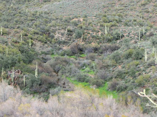 |  |
| Everything is green today | Green ocotillo |
 |  |
| Closing in on the river | Trail through cacti |
After arriving at the river we walk along it searching for any crossing but there is no hope of this and the river seems quite muddy and turbulent and the danger exceeds the risks we are willing to take so we decide to turn around at what is likely about one third of our intended hike. Even so we had a lot of interesting sightings including the bald eagle so we are happy we decided to hike this segment and plan to return some other less rainy time.
 |  |
| Fun contrast | No way will we try to cross |
 |  |
| Doesn't feel like Arizona | Water is quite turbulent today |
After last's week short hike we are ready for something more difficult and we settle on Saddle Mountain. While the hike is not that long the elevation change is significant and we are sure we are going to feel it. In addition we don't even know if a trail exists up to the top so bushwackng might be required. The start is relatively tame with the trail climbing relatively slowly towards the seemingly impenetrable mountain.
 |  |
| Where is the mountain we are supposed to be climbing? | Ah..there it is |
 |  |
| Starting on the trail | High up already still only halfway |
The rate of ascent becomes faster as we now follow the fainter trail up and up a wash towards the ridge which still seems impossibly out of reach. The views however are great which is good as we stop almost every five minutes to catch our breath.
 |  |
| Water along the way | Colorful lichen |
 |  |
| Even higher up | Wash/Canyon we climbed through |
The last part is the most difficult, the trail disappears many times and the ground becomes loose and slippery so we are happy when we finally reach the summit with great views in all directions. We rest a bit here to let our muscles relax before what promises to be a white knuckle descent.
 |  |
| Still going up | Uhm...that down there is where we started |
 |  |
| Now we are on top | Looks easy here - it was not |
Somehow the descent goes without a hitch (except a few scratches but given the potential we are happy to escape with only that) and soon we are in the valley. Here we decide to explore a bit more before sundown and to our big surprise we find a desert tortoise sleeping under a rock - the first wild tortoise we have ever seen. We look at it carefully from a distance, it is impressive that they survive in this type of environment and as darkness falls we return to the car and Phoenix after a tiring and beautiful day.
 |  |
| Looks nice | What a pattern |
 |  |
| What is that under the rock? | OMG - our first live tortoise |
Quien Sabe Peak has been on our radar for some time as it is the highest peak in this area that we hiked multiple times. However there is no official trail that goes up the mesa so we know it will be a hard ascent and therefore we always left it for later....until today. The drive to the Seven Springs TH of the Cave Creek Trail is uneventful and soon we are on our way crossing Cave Creek and then following the established trail into the mountains up and up towards Quien Sabe. After a few miles we arrive at the point where we have to off trail on a route that we mapped at home and we hope is the best to climb the Peak. Surprisingly the first part is on an overgrown road that we follow to an abandoned mine but after that we are following the ridge towards the mesa with only animal tracks to follow.
 |  |
| Start of the trail - always up | Water crossing at Seven Springs |
 |  |
| Trail intersection in the wilderness | View partway up |
 |  |
| Exploring an old mine road | The mine |
When we look back we are surprised at how much we climbed, with the trail it is much easier than now when we try to avoid small peaks without falling off the side of the mountain. And then suddenly we just stumble onto a small Indian ruin which we explore for a while finding a few rooms and some pottery shards before moving on.
 |  |
| A long way up from parking | Scenic tree |
 |  |
| Anasazi ruins on the way | Pottery at the site |
 |  |
| Agaves are everywhere | A fire passed through here |
As we get closer and closer to the top the going gets harder and harder so we are happy when we finally arrive on the top of the mesa and we have some time to rest and enjoy the spectacular views. After finally catching our breath it is time for the descent which is slightly better as we already know the best routes more or less and we arrive at the car right as darkness falls after our very exhausting, even though relatively short, hike.
 |  |
| There is still snow on the mountains in the distance | We have to pass through that crack...likely |
 |  |
| On the top of the Mesa - our goal | What a view! |
Most every year we go to Quartzsite for the Gem Show however this year we decided to switch it up a bit and go to the Tucson one instead which is supposedly a major one but we never went to. Just finding out where to go is quite confusing as it is split across multiple sites. Our first stop has basically no other visitors and as we walk around to a different site we find that everyone is already packing even though it is mid day. At least we can walk through a few fossil exhibits but it still feels a bit disappointing.
 | 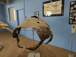 |
| Is it the Gem Show or the Fossil Show?! | Very old turtle - I think |
 |  |
| What are the miracles that happen here:)? | Cool street art |
We decide to drive along the different places where the show is held and see where the most visitors are and we decide to stop at the Convention Center where both the parking and entrance is for money in contrast with the other sites. At least here the show seems to be in full swing so we decide to enter the show room.
 |  |
| Arriving at the Convention Center | Lobby greeter |
 |  |
| View of the Gem Show from above | Lots of people in huge hall |
The exhibits are impressive both those that won and those that didn't - there are lots and lots of gems and minerals on exhibit but also jewelry. Most stones/minerals can also be bought some for quite impressive amounts of money.
 |  |
| Nice exhibit | That is a lot of malachite |
 |  |
| One of the awarded exhibits | And another one - that is a nice green |
 |  |
| Some jewelry | Gold is also exhibited |
After walking around for a couple hours we get hungry and tired and decide to stop at the food trucks to eat something and sit down. To our surprise all food trucks are closed and are prepping to leaving - luckily one inside vendor is still open and we eat pretzels and hotdogs, still a bit weird that the food trucks closed more than two hours before the show.
 |  |
| The food trucks | All of them closed - ouch |
Refreshed we continue our visit focusing on fossils and more interesting exhibits and even buying a few small souvenirs. Time flies and soon it is closing time so it is time for us to get back to the car and PHoenix.
 |  |
| Fossils are also for sale | Trilobites and other prehistoric animals |
 |  |
| Pink crystals | And whatever this is:) |
Looking at the map one day we were surprised to see a big national park south from Phoenix, the Sonoran Desert NM, and since then we always wanted to visit it as long as we find a good trailhead. Today we finally decided to take the plunge and try to hike the Butterfield Stage Route Trail which is temporarily closed for cars, for almost 10 years already even though it was supposed to be only for 2 years. For us today this is good but if we wanted to go to the trailhead(TH) further up just hiking 3-4 mi till the TH would have made it impossible to really hike on the official trail.
 |  |
| This way is closed | The "right" way |
 |  |
| Map with "temporary" closure | Lots of trails in this direction |
The area here seems very secluded with very few visitors even though it is very close to Phoenix and has some interesting historic sights that we hope to see today. The trails however are very flat and not that scenic which is likely the reason why they are not used that often. To us the hike is fun especially the flowers that are just appearing by the side of the trail and it is fun just exploring the area as we walk towards the Butterfield Trail.
 |  |
| Trail/road in the beginning | Trees are welcome |
 |  |
| Yellow flower near branch | A bit of yellow near a dead cactus |
About two miles into the hike we reach the prior trailhead for the Butterfield Trail with an abandoned restroom, a bit sad that they closed the whole area randomly it seems. From here we follow the Butterfield trail towards the historical sights that we came here to see - we have still have about 2 miles to go to the first stop. On the way we are surprised to notice that many signs are destroyed, not sure if this is from before they closed the trail or after. Still someone put up new signs from time to time which is quite good at intersections.
 |  |
| Modern restroom two miles from parking | And a water tank |
 |  |
| Historic trail starts here | It was a wagon trail |
 |  |
| Signs don't seem to last here | Some end on the side of the road |
Given the flatness of the terrain we make great time and soon arrive at our first goal - the Historic Happy Camp Cistern. WHile there is no water in it - historically it was carted in from a nearby village - it was a very important rest stop on the Butterfield Trail given the scarcity of water in the desert. It is interesting to know that so many historical trails passed through the exact same spots which makes sense - why create a new road if you can use the historic one?
 |  |
| Interesting sign in the distance | Mormon trail marker |
 |  |
| Historic Happy Camp cistern | No water can be found anymore |
WE continue up in the pass where we find an interesting enclosure for sportsmen - not sure why it was created and what is supposed to happen there but it doesn't appear to have been used for some time. And soon we are on the top of the pass and our turnaround point after 5.5 mi as of course we have the same distance to cover on our return.
 |  |
| A fence after 5 miles of hiking | How do these sportsmen get here? |
Here in the pass there are many saguaros, almost a saguaro forest, which is a nice contrast from the flat region where we could barely see a few from time to time. The hike back is uneventful and as we approach the car we are treated to a very beautiful sunset - Arizona sunsets are the best :).
 |  |
| Sudden saguaros | Walking back towards the car |
 |  |
| Evening flower | Sunset |
Every year we try to make our way to the Archaeology Expo especially if it is at an interesting location like this year on the Tohono Oodham Nation lands in Topawa. Just getting there is a 3 hour adventure from Phoenix mostly on the Reservation lands (the third largest reservation in the US). We arrive around 1PM and to our surprise find that there is still a place for the 2 PM tour to Anasazi petroglyphs and we sign up of course and enter the expo area. As we know that we won't likely be back before the expo closes we have to see as much as we can and eat something before starting on the trip. Here the food trucks are still offering food but it is excrutiatingly slow and we get our fry breads only 8 minutes before tour start so we have barely time to take a few bites before the tour starts.
 |  |
| Expo is on Tohono O'odham Nation lands | Visitor Center |
 |  |
| Inside the expo - lots of people | Old style fence |
 |  |
| Trying to eat fry bread | Lots and lots of toppings |
While the tour was asking for a 4WD car the road isn't really that bad but high clearance was really helpful. It takes about 10 miles to arrive at the petroglyph site which is inside an Indian Park which is free today for the Expo visitors. It is a short hike to the base of the stone outcrop where the petroglyphs are - there are two panels as our guide explains to us with the first one being the better preserved one.
 |  |
| Petroglyph tour | Old tool found on site |
 |  |
| Our goal - petroglyphs are at the base | Nice view |
 |  |
| Imposing rock | Crows are circling above |
We soon stop at it and yes it really is well preserved due to an overhang that protected it against the rains. Here there is a mix of petroglyphs and pictographs and while many symbols have unknown meanings even we can identify the proeminent sun and turtle.
 |  |
| Lots of petroglyphs | What do they mean? No one knows |
 |  |
| This one is more obvious - a turtle | And the sun |
There is a much smaller (not counted) panel close to the main one which besides older symbols also has a few that we can only assume are newer in origin. OF course besides the petroglyphs there are also pottery shards to be found and other remnants from the time this place was considered sacred to the Anasazi.
 |  |
| Artificial hole for grinding food | Pottery shards found nearby |
 |  |
| Group at the main petroglyph panel | Smaller panel nearby |
Next it is time to move to the second panel but on the way we (and everyone else) are attracted to another rock which has an obvious petroglyph on top - we cannot decide if it is ancient or not given how well defined it is on its exposed spot.
 |  |
| Quite a view | More cacti than usual it seems |
 |  |
| What is so special here? | What a place for a petroglyph |
The second panel is more faint but still interesting and after exploring it it is time to go back to the car while enjoying the views and then towards the expo.
 |  |
| The second major panel | A lizard or something like that:) |
 |  |
| View on the way back to car | Special cactus |
To our surprise the convoy is heading in a different direction and following it we arrive at a separate park - this one set as a picnic area near a nice creek and also the starting point of hikes in the nearby mountains, supposedly only with guides. After enjoying the picnic area and finally finishing our fry bread it is time to go back to Phoenix passing the annoying border control checkpoint inside the US with little hassle this time which certainly puts the cherry on top to this interesting trip.
 |  |
| Close by picnic area | Near a cool creek |
Due to an unseasonably hot day in Phoenix we have to drive a bit farther to find a place to hike without being uncomfortable. We settle on Prescott which is high enough to make the temperatures bearable. We decide to try an area that we hiked in before but a different hiking trail than previously. Before even starting on the hike we want to see one of the rare surviving Charcoal Kiln so we drive past the trailhead arriving at a village lost in the pines where we have to find the trailhead for the short trail to the kiln. We cannot find it initially passing the entrance towards the trailhead but then we return back and park right at the entrance as the road past it doesn't look to be maintained that well. In fact the residents are using a different road which is marked private while the public one is not maintained which is a bit annoying but the hike is short enough that it does not matter. The kiln is surprisingly well preserved and can be entered for a nice view of the interior and we wander around for a bit admiring it before returning to the car.
 |  |
| That is a bad spot for cars | Trail start |
 |  |
| Walker Charcoal Kiln | Inside the kiln |
We drive back to the trailhead for trail 62 which is the one we intend to hike and find to our surprise that it closes at sunset - we like to hike during the evening but now we have to plan to come back before the trailhead closes. We change our plans a bit and decide that instead of a loop we are doing an out and back that is easier to control timewise and we start immediately on the trail after eating a fast lunch. The trail is going up relatively constantly and soon we have some nice views of Prescott and the San Francisco Mountains far in the distance.
 |  |
| Trailhead restroom - nice | Start of trail |
 |  |
| Again going up:) | View of San Francisco Mountains in the distance |
Along the trail we even notice the first spring flowers, it is great to know that even at this altitude the flowering season is starting that early actually. More surprisingly in the higher altitudes we suddenly meet a newly bulldozer-created path(?) which intersects the trail quite a few times making the trail choice interesting. Unfortunately we cannot find our where the new path goes as we soon have to return to the car that we reach half hour before closing time and then it is time to go back towards Phoenix after a nice day into the pines.
 |  |
| Very dense vegetation | Flower |
With the temperatures back to normal we can return to lower altitudes this week and we decide to explore a part of the Black Canyon Trail (BCT) we never explored before. We park near the main dirt road passing through the area and walk a small distance through the flowering desert towards the intersection with the trail.
 |  |
| Starting point with great view | Side road to Black Canyon Trail |
 |  |
| Flowering agave | Beautiful color |
As we approach the trail we notice something colorful at the intersection - to our surprise it is a huge toy truck, why you would want to bring it here is we cannot fathom. With the mystery out of the way we can follow the trail from here as it initially shadows the road before starting a scenic descent through a canyon.
 |  |
| Not what you expect on the BCT trail | Joining the trail |
 |  |
| Trail is quite scenic | So many flowers |
While we don't hike a lot today we certainly enjoy all the flowers on the way - the spring bloom is in full swing everywhere with flowers of almost every color being everywhere we look. It is very impressive and we take lots and lots of photos before returning back to the car. As there is still light we decide to try a different exit on a different dirt road which is quite interesting especially at some point where while stopping we hear a chorus of coyotes from seemingly everywhere in the falling darkness. It is scary and exhilariting and we are happy we have the car right next to us:) that can take us back to civilization easily.
 |  |
| Blue and yellow | "Artistic" photo |
 |  |
| The blue flowers | And the yellow ones |
We have been on Table Mesa a few times but now we want to explore a bit father than usual towards Tip Top. There are two crossings of the Agua Fria River and we try the first one described in our guide book but that one unfortunately is private now so we have to turn around and try the second crossing.
 |  |
| Where is the road? | Cactus flowers near the road |
While the second crossing is open the road down towards it looks a bit dangerous to us so we decide to stop and hike from there on the close Black Canyon Trail instead. We even find a secret overgrown connector trail from a parking lot at the bottom that goes towards the BCT trail through the greenery. It is a short hike and soon we are on the BCT loop and ready to explore.
 |  |
| Start of secret trail | Lots of greenery |
 |  |
| Cacti are in flower | Nice yellow |
First we decide to explore a mesa above the BCT trail, it actually has a faint trail that makes a loop along the edges of the mesa so it is quite an enjoyable walk as we look at the views and explore the flowering bushes and cacti.
 |  |
| Black Canyon Trail stretch | Bad stretch of road from a distance |
 |  |
| The less travelled path | Ocotillo in bloom |
The best views are of course on the Agua Fria side with the water far below us until we decide to take the BCT trail to the other side. Of course that means that we have to cross the river which is quite fun as it is a bit on the warm side outside while the river is quite cooling.
 |  |
| Canyon and Agua Fria River | Getting close to the river |
 |  |
| Time to cross the river | Wide but not deep |
We have chosen to cross the river in order to explore an Indian Fort nearby - it is on our 4x4 guidebook as being accesible by car but we can do it on foot as it is quite close. In fact we can see it from a distance it is very impressive from all sides and even entering it is an adventure as we have to climb through a narrow opening onto the plateau.The view however is worth it, it is certainly one of the reasons this spot was chosen - the 360 degree view would have covered all approaches and the proximity to the water was certainly highly priced.
 |  |
| Approaching the fortress | Quite a place for a fort |
 |  |
| Looks like a castle | The entrance is somewhere here |
 |  |
| View from the fort - impressive | Walls are not that impressive from the inside |
We still have some time so we explore the BCT a bit more until it gets dark, we even find something that might be graves near the trail but not sure what they are exactly, quite weird. After returning to the car it is a careful drive to the main dirt road and then smooth driving to Phoenix after a fun day in the sun.
 |  |
| Are these graves? | Beautiful to see but very sticky |


No comments:
Post a Comment