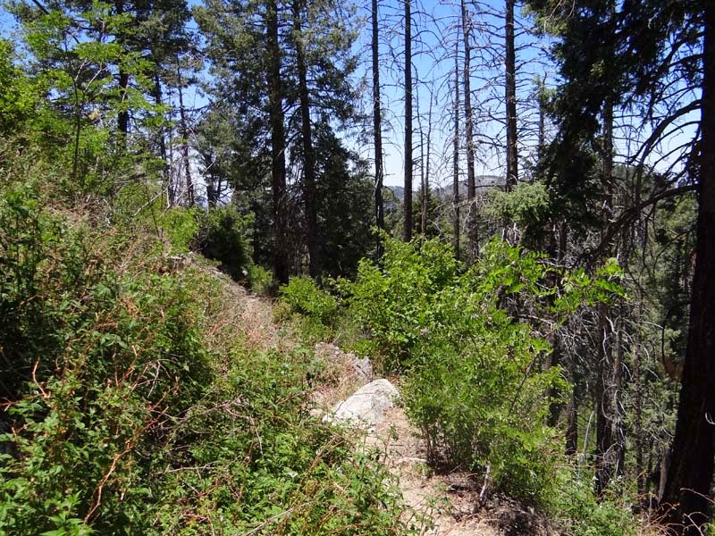
The Orme area is a place which we like to visit due to both the relative remoteness of the area and the beauty of the landscape. Today we plan for a few hours hiking around on a few side roads and exploring the area. The side road off Orme that we choose initially is not as secluded as we expected - there is even a water pipe running along it and after we encounter some machinery we decide to try a different one and move on to the next side road.
 |  |
| Side road from Orme | Water pipe in the middle of the desert? |
 |  |
| Equipment on side of the road | Expansive view |
The new side road is more promising as we arrive at an old abandoned homestead which is quite interesting even though we find no evidence of a house in our exploration. The windmill nearby however is well preserved even though it is not working anymore.
 |  |
| This is what happens to signs out here | Signs of humans are everywhere |
 |  |
| Part of an abandoned farm | Entrance to abandoned farm |
 |  |
| Car parts in the wilderness | Windmill near the road |
Our turnaround point for the hike is a ruined house that we find after about a 2 hour hike. We explore it but cannot determine when it was built, is it new or an older one? The cows in a pen nearby are observing us with interest and then to our surprise decide to walk out ..they are not really closed in. But they walk away from us watching us as intently as we watch them to make sure they don't turn around. The walk back to the car is uneventful however we have some troubles getting out from our parking spot due to a trench in the road but after we place a few rocks in the trench we make it to the other side and on the bigger Orme road.
 |  |
| Wall of ruined house | Cows in pen near ruined house |
 |  |
| They decide to leave..it is not closed | Well preserved walls |
 |  |
| Does it really matter? | Bird watching |
 |
| View from Black Mesa Ruins |
Today our plan is to get to a hard to reach Anasazi ruin near Black Canyon City. It is hard to reach both because there is no easy access and because in sits on a mesa top with no easy route up. WE start near Black Canyon City and park at the border of Agua Fria NM before starting the hike. From the beginning there are interesting rock formations to observe as we follow a road that we hope will bring as near the desired mesa.
 |  |
| Entering Agua Fria NM | Interesting rock formation |
 |  |
| Rock tower in the distance | Relatively close to the interstate |
Soon we discover that the road ends in a wash and from there we hike cross country towards the mesa that we have to climb. Luckily there is no impassable ravine on the way and we soon arrive at the base. The climb is arduous but we find a path first to the saddle and then a more defined path that goes towards the ruins. In fact the climb overall felt easier than it looked and soon we are in front of them eager to enter. The walls look quite well preserved from outside so we are excited to see how it looks inside.
 |  |
| We are going to the top | Getting closer |
 |  |
| We can see the ruins..one more push | Close enough |
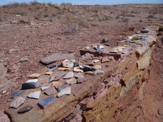
Before we enter however we explore the area below first and find quite a few shards of pottery and some petroglyphs on the stones at the base of ruins.
 |  |
| Different shards of the previous inhabitants | Is this natural or artificial? |
 |  |
| Petroglyphs on the rocks nearby | Interesting lizard like petroglyph |
The views from the top are magnificent and we can see the whole surrounding area from above. We can also see how far we have climbed and it is impressive (to us at least). The entrance is easy to find as the fortification is built in a well defensible position with only one side easily accesible.
 |  |
| View from the top of the mesa | This is where we are coming from |
 |  |
| Usual sign at the entrance | Rooms are clearly distinguishable |
The ruins themselves are one of the most impressive that we have seen with walls bigger than ourselves. This is the first time we have seen walls this big on hilltop ruins and as we wander around exploring room after room we wonder behind the reasoning for this fortress. Was it a lookout post? - it looks too big. Was it a permanent location? - it is too far from water. But the views from it are excellent with nice vantages of the surrounding area.
 |  |
| Well preserved walls | End of the ruins with great view |
 |  |
| Walking through the ruin | Great defensive position |
After thoroughly exploring the ruins we start the hike back to the car and are happy that we make the descent prior to full darkness as even the return on the flatter terrain at the base is slow going until we hit the road where we can walk normally without worrying of hitting a cactus or falling in a ravine. Overall a great day out and a spectacular ruin both remote and close to civilization.
 |  |
| Great moss pattern | Sunset on our return |
Today we are trying to access the Richinbar area, that we visited before and enjoyed, from a different access point. On the map there seems to be a road that passes the only obstacle on the way from the new access point..a ravine. The road however proves quite soon to be a chimera. In fact it seems to end right at the edge of the ravine and what we assumed is a road is in fact a pipeline clearing going straight down. Somehow we make it down and on the other side we find again the road overgrown quite badly but still something that we can use to reach the small ranch from which we know the way to Richinbar.
 |  |
| Trail on top .. easy | View of the mesa |
Before going to the ruins we take a short sidetrip to some nearby petroglyphs. They are located on the top of a hill on a few stones and they are quite interesting. There are mostly sheep drawings but there are also a few deer, symbols and an unidentified animal.
 |  |
| Petroglyph wall | Bighorn sheep petroglyphs |
 |  |
| Deer?! | What animal is this one?! |
The view from the petroglyph area is great as we can see along the Agua Fria Canyon both upstream and downstream. The river is not flowing however there are a few small ponds on the river bottom which look interesting from our high perch.
 |  |
| Agua Fria Canyon | Close view of canyon |
 |  |
| View down canyon | Nice view of canyon |
From the petroglyph area we walk towards the Richinbar city ruin area. Close to the petroglyphs we find the first ruins, a few houses and a bigger ruin likely related to mining which we explore more in depth and which is full of old nails to our surprise.
 |  |
| View of ruin from distance | Close up view of mine ruins |
 |  |
| Windmill in the distance | On top of the mining ruin |
 |  |
| Deep hole | Lots of nails |
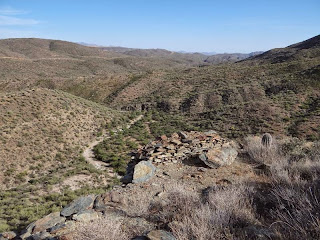
Next we arrive at the main mining site that we have visited also before. It is surprising how this area sits so close to the interstate and is so rarely visit with the wealth of remains from the mining days. We walk around looking at the mining shafts, ruins, car remains that are strewn throughout the place before starting the walk back to the car.
 |  |
| Main mining site | Is this a natural dam? |
 |  |
| Mine shaft | Richinbar ruins |
 |  |
| Old overgrown town | Old car part |
On the way back we explore the little ranch area more in depth especially an open shed that appeared to have been lived in (quite some time ago). And then we walk back towards the ravine but we have one more hiccup.. the gate towards the ravine is guarded by two bulls and a few cows that look in our direction and not exactly friendly. So we walk up the fence a bit and then pass under it instead of using the door and after that we descent into the ravine in the falling darkness. Everything goes well as we use our flashlights for the climb up and short walk to the car afterwards. Quite an enjoyable day in a nice area that still has a few places left for us to explore.
 |  |
| Farm on the way | Open shed |
 |  |
| Inside the small shed | Old destroyed bed inside |
The area that we intend to visit today is the Seven Springs Area and the close to it Maggie May Creek Area. We start with Seven Springs which we intend for once to visit in more depth as usually we park at the trailhead and bypass the recreation area. Today we enter what was once a nice camping area but now it is day use only likely as a result of a flash flood that happened a few years ago. There is no one around as we explore and we even find a nice nature trail with descriptive signs that goes up to the top of a nearby hill.
 |  |
| Seven Spring Recreation Area | Restroom at Seven Springs |
 |  |
| Nature trail plaque | Unexpected view in the forest |
There are nice views from the short trail including one of the water crossing before the Seven Springs Area. As we observe it for a while we capture one truck crossing it..it looks more difficult than it is given that small cars can also make it most times.
 |  |
| View from the trail | Road water crossing |
 |  |
| Close up of crossing | Car crossing the river..looks fun |
After arriving back at the base we eat a quick lunch and then drive the short distance to the Maggie May Creek area where we drive in a short distance before parking and then starting our hike. There are a few wildflowers right where we park that we enjoy before starting our climb towards our goal an old cabin further down the road. The road climbs fast but we pace ourselves and soon we arrive at a pass with great views of the surrounding area.
 |  |
| Common flower in the spring | Yellow seems to be the preferred color |
 |  |
| View of the area | Road that we are hiking on |
We had seen a picture of the cabin in a book and it was more or less intact but as we arrive we are surprised to see only ruins...a lot changes in a few years. Even the tree supporting it is gone, cut or broken down by the elements.
 |  |
| Abandoned cabin in the wilderness | Close up of fireplace |
 |  |
| View of cabin from the outside | Likely part of cabin |
The surrounding area is nice with pools of water in a nearby wash and mountains and even trees nearby. You can see why someone would build a cabin here even though it was likely because it was close to a mining claim or where the person was prospecting as this was a very active mining area. In fact our next goal in the area is an old mining adit which is on a different side road in the same general area.
 |  |
| Temporary water source nearby | Road through the riparian area |
 |  |
| Road in the evening sun | Lonely tree near the road |
The side road is a bit more strenous than the one to the cabin with a few steep ascents and descents but after about 1/2 mi we arrive at the adit. Unfortunately it doesn't look safe to enter but it looks like the shaft is quite deep when we look in from the entrance.
 |  |
| Mine shaft near the road | Doesn't look safe |
From the mine we return to the car however we have to stop multiple times to take in the beautiful sunset. This year it has been an abundance of great sunsets and this one is one of the best with great views of the setting sun against the surrounding mountains. After the sun is gone we hurry back to the car and then towards Phoenix. However we still have an interesting encounter at the water crossing near Seven Springs where we see our first raccoon in Arizona...likely he was just drinking water and was shocked as much by us as us by him. However that was the last adventure and the remaining distance was uneventful.
 |  |
| Beautiful sunset | Last rays of the sun |
 |  |
| Clouds over the mountains | Another great view of the sunset |
 |
| Montezuma Well |
Today while driving with a friend to Flagstaff we decide to stop on the way a few times and show her some of the more hidden attractions of Arizona. First we decide to do a short hike down Badger Wash to the Agua Fria River. It has rained the previous days so even accessing the trailhead is a bit of adventure but we make it and arrive after a short hike at the river. The river is bigger than we have ever seen it seemingly furious and roiling against its banks so we decide not to tempt the fates and cross it and stay on this side of the river and take quite a few of interesting photos.
 |  |
| End of Badger Spring Trail | Agua Fria after rain |
 |  |
| Trees near the crossing..not today | Close up of water |
Our next stop is Montezuma Well a separate unit of Montezuma Castle NM which is also free to enter. A short hike from the parking lot is leading to the top of the crater like area in which the lake sits. The lake is fed by an underground spring which we find out from a ranger has more arsenic than usual and as such was poisoning over the long term the Anasazi that were living nearby. However the wildlife seems to thrive in the area as we see multiple ducks and a few squirrels as we descend to the lake.
 |  |
| Montezuma Well from the top | Going down..interesting sign |
 |  |
| Birds enjoying the rare water | Wildlife near the trail |
There are old Anasazi ruins everywhere, on the top, in grottos beneath the rim and at the bottom. The ones at the top and at the bottom are more easily accesible and the one at the bottom has been inscribed by multiple tourists along the years prior to the area becoming a National Monument.
 |  |
| Ancient Anasazi ruins | Close up of ruins |
After exiting the "caldera" we walk around to where the water is exiting the lake in an imperceptible crack. The stream empties into the Agua Fria further down but while it flows parallel to it it was used by the Anasazi to water their crops using canals that were diverting water along the way.
 |  |
| Swollen Agua Fria River near well | Outlet from well |
 |  |
| Used for watering in prehistoric times | Lots of trees due to the permanent water |
While leaving the area we stop at another exhibit of an old Anasazi house that was found some time ago and stabilized at the time. Since then a roof has been constructed to protect it from the rain and it is fun to imagine how the house looked hundreds of years ago.
 |  |
| Imprint of an Old Anasazi House | Detail of the imprint |
Last stop on our tour of the area is Jerome an old mining town that was one of the largest cities in Arizona before the mines closed and it became a ghost town. Since the 70s however artists have started to move in and now it has a healthy artist community and even the old hospital has opened as a hotel if visiting the area. We walk around and enjoy the views and the old houses some renovated and some delapidated and interesting to view. As it gets dark we return to the car and drive to Flagstaff where we drop off our friend before returning to Phoenix late at night.
 |  |
| Jerome View | Houses in Jerome |
 |  |
| Moving Jail | Impressive Mansion |
 |  |
| Interesting museum... | ....and interesting sign |
We wanted to explore the Mt Ord area in more detail for some time and today we decide to drive out there and hike around and explore the roads. We drove on the main road to Mt Ord a few times so today we plan to test the backroad to Mt Ord. But first we have to get there - we are always impressed by highway 87 and how to lanes crisscross each other as you climb and descent and so on. The views are great especially in spring with yellow wildflowers everywhere.
 |  |
| Spring wildflowers | Four Peaks in the distance |
 |  |
| Going down | Near the road |
We do not know the exact exit so we exit the highway a bit earlier than we should have in a nice area near the highway. While it is immediately clear that this is not the correct spot as there is no road starting from the parking area we explore a bit around it finding a flowing small creek and quite a few wildflowers nearby.
 |  |
| Highway near Mt. Ord | Flowers are everywhere |
About a tenth of a mile afterwards we find the correct exit and park our car at the bottom and start hiking the road. We have read that it is a tough 4x4 road but in the beginning it actually looks easy besides being narrow. But soon our opinion changes as we find the road washed out and supported by something that likely was built for mining purposes and not for road support.
 |  |
| Doesn't look so bad | But this does |
 |  |
| What is this for? | Related to mining? |
The road goes up and up with lots of switchbacks but after some climbing we arrive at a great vantage point from which we have great views of the area. Before taking in the view we explore the area a bit which seems filled with remains of mining activities of past decades.
 |  |
| Quite high already | Old mine shaft |
 |  |
| Castle on top of the hill? | Not really...more modern |
The views are beautiful and as we get higher and higher we stop more and more to enjoy the views. Besides the overlooks over the highway as the road curves we get some views of nearby manmade lakes and impressive peaks. Finally we decide to return in order to make a few more stops and we start our descent which is much faster than the ascent....wonder why?
 |  |
| View from high up | You can see the pipeline cut |
 |  |
| Even further up | Wall protecting the road |
 |  |
| View from turnaround point | Surrounding mountains |
Our next stop is close by and it is a small riparian area that we explore trying to see some of the birds that are sure to use such a good habitat. Unfortunately besides a cardinal we do not see any birds so we move on to the last stop on our intinerary the Deer Creek Trailhead where we intend to do a short hike.
 |  |
| River from above | Not really flowing |
 |  |
| Close up of water | Canyon and water |
The hike is beautiful and there are quite a few wildflowers along the way - it seems today it was a day full of wildflowers. We watch the sunset and then after the sun goes down we return to the trailhead and then to Phoenix after this full day.
 |  |
| Hummingbirds like this | Flowers near the road |
 |  |
| Yellow is everywhere | Close up of flower |
Today we want to visit the Arizona State Museum in Tucson that we have seen mentioned lately and never visited before. The major problem is finding parking in Tucson in the area of the University of Arizona but we find it in the first parking garage we try albeit at the top floor in the sun only. We decide first to explore the area to find a restaurant as we are really hungry and are really surprised by the number of people on the main street. We soon find out that the reason is that there is a game and all the bars are choke full of supporters. With some difficulty we find a Greek restaurant that has some seats and we order however it takes some time to receive the food. At least the food is good and we continue on our way refreshed.
 |  |
| Gyro dish | Lamb leg |
Right after we enter the campus we find the Arizona State Museum and enter it. To our surprise it is free of charge somehow we arrived at one of the few days where they have free entry to the campus museums and it is full of people as a result. The museum is small but interesting to visit with a lot of information regarding the ancient and current Native Americans as well as a good Anasazi pottery collection.
 |  |
| Arizona State Museum | University of Arizona Campus |
After the museum we continue our exploration of the campus and we find another free open museum this one the Flandrau Science Center and Planetarium a Gem and Mineralogy Museum with some interesting fossils including coprolites.
 |  |
| Coprolite | Interesting collection |
Another interesting highlight is the hall which was a central part of the "Revenge of the Nerds" movie which looks impressive from the outside. By this time however we are heading back to the car park as it is getting dark but before starting back we take one final look at the moon illuminated landscape from the car park rooftop and then start our drive back to Phoenix.
 |  |
| Hall from "Revenge of the Nerds" movie | Last view of campus |
Another weekend another day exploring ancient Anasazi ruins. Today we are going to an area near Camp Verde that we pass quite often but never stopped to explore. We know there are some ruins on top of a mesa and in the cliffside and we noticed a parking area at the bottom so we assume there is a trail going there from the parking area. We are proven correct and the trail climbs easily at first and then more strenous towards the cliffside homes.
 |  |
| That's where we want to go | Getting closer |
 |  |
| And even closer | Too close:) |
On the way we find lots of pottery shards and as we start exploring the cliffside homes we find other evidence of prehistoric habitation including soot on the roof of the caverns and old corn cobs.
 |  |
| Pottery shards are everywhere | Rare remnant of Anasazi times |
 |  |
| View of the valley | View from higher ground |
There are also of course Anasazi ruined walls everywhere and great views of the valley below. What is more surprising are the holes dug in the floors, they seem to be done by someone looking for something...archaeologists...tomb robbers..who knows? (Yes we saw too much Indiana Jones:)).
 |  |
| Anasazi walls in the grottos | Foundation in one of the caves |
 |  |
| View from inside | Are the holes from the Anasazis? |
 |  |
| Nope they look newer | Wonder who done them? |
We wander around the ledge a bit exploring the different dwellings and enjoy the great views and then try to find the trail up to the mesa however every way we turn it dead ends. Finally after some investigation we find a rocky path that leads us to the top.
 |  |
| Living on the edge | But with nice views |
 |  |
| Looking outside | Interesting trail..or maybe we are lost |
Right where we arrive at the top we find an extensive hilltop ruin which is quite beaten down by the elements now so sometimes we can barely see the room walls. However there are quite a few pottery shards and it is impressive how large the fortress was.
 |  |
| Another fortress on top | Outline of walls on top |
 |  |
| Close up of former rooms | Pottery shards on top |
After visiting the fortress we continue walking on the mesa top following a faint trail that does a loop on the top. There are lots of flowers around after the rains which is nice to see in Arizona.
 |  |
| Top fortress ensemble view | Lonely plant |
 |  |
| Bright red | Juniper berries |
After descending there is still time so we go exploring a nearby area off a major dirt road. We start walking on a side road which is quite nice to hike as it is level and is full of wildlife including a very attentive quail.
 |  |
| Lonely dirt road | Nice road to hike on |
 |  |
| Quail surveying the area | Common species of cacti in the area |
We climb on a small mesa and even here we find multiple pottery shards which is a sign that this area was inhabited heavily during Anasazi time. But we are impressed also by the wildflowers and of course the beautiful sunset that we experience while returning back to the car after an exhausting day.
 |  |
| Wildflowers are everywhere | Close up of interesting stone |
 |  |
| Great sunset | Sunset in Camp Verde |
This weekend we plan a longer trip where we will stay a night at the historical La Posada Hotel in Winslow. Going there we first make a short stop near Camp Verde at the West Clear Creek to enjoy the flowing spring waters and see the luxuriant vegetation. We walk along the river a bit but there are lots of other people so we decide to return to the car and continue on our way.
 |  |
| West Clear Creek | A lot of water for Arizona |
 |  |
| Quieter place | Nice spot to relax |
On the way back we look at a few crows flying around and in the end decide that they likely defend their nest high up in a tree. They are really protective of the area against other birds and also eye us suspiciously.
 |  |
| Creekside tree | Crow's nest |
Our next stop is relatively close, a side road before reaching the Rim that we wanted to explore. It actually leads to an overlook of the West Clear Creek but we don't have time to do the full hike and stop after about 1/2h after discovering some great views of the valley and then return back to the car.
 |  |
| Road/trail through the wilderness | Waterhole in the wilderness |
 |  |
| View from the trail | Camp Verde Valley |
As we reach the Rim we are surprised to see the Rim roads already open so we decide to explore a bit. We park and walk through the forest and discover a complex that seems to be closed for the winter - well except for the sign which is a bit scary so we leave - just in case.
 |  |
| Abandoned area? | Uh oh...really? |
 |  |
| Everything is boarded up | Including the shed |
The forest is unusually quiet this time with no other visitors around and we enjoy our walk however it is getting late (and cold) and we still have some driving to do to Winslow where we also want to catch dinner at the renowned restaurant of the Posada Hotel.
 |  |
| Ah that's what it is | Quiet forest road |
When we arrive to our surprise it is quite difficult to find a parking spot something that we didn't expect and we have to park further out in a dirt lot and not in front. As we walk back towards the entrance we notice that actually a lot of the cars are luxury cars (Rolls Royce's and such) and actually quite a few of them are from Europe. After a bit more research we find out that it is a tour of the USA for vintage luxury car collectors - what a coincidence to meet up with them exactly in Winslow.
 |  |
| Rolls Royce in Winslow?! | Ah..a tour of USA |
After checking in (at the gift shop to our surprise) we go to explore our room. It is in the corner of the hotel and towards the railway. In fact the hotel itself is one of the "grand" hotels built along the rails for the people to eat and sleep overnight- one of the last ones built before the Great Depression and the end of the railway hotels. As a result we even get some earplugs which will we useful during the night as the trains keep passing through.
 |  |
| Inside of room | This is something new |
But before sleep we first go to the dinner room to eat. Unfortunately due to the group there is no place until an hour later so we wander around the hotel until the hour passes and we finally can get some food as we are famished. The food is good and filling and we get to bed as we are tired and the next day is a long day.
 |  |
| Lamb sampler platter | Osso bucco |
In the morning we explore the hotel grounds more carefully. The Winslow train station is that in name only as the old building is now a museum and the waiting hall is now inside the hotel. The train stops only once (or twice) per day now and we haven't seen any passengers waiting for it during our stay. As we explore we find a maze - not sure if it is finished or not but we try it out and it is fun trying to find the exit - at least we can easily see where each path goes.
 |  |
| Part of the hotel we stayed in | And this was just across |
 |  |
| The Winslow train station | Maze in the gardens |
The gardens are still bare as it is early spring but there are some tulips at least in the garden. The main area of the garden is full of decorations some of them quite interesting including the cannon that was bought supposedly from Mexico.
 |  |
| Too early for many flowers | Garden ornament |
 |  |
| The sharks are coming | Busy area of the garden |
After our exploration outside we go inside and research Inside we find a map of the world where the visitors placed a dot where they visited and it is an impressive map (we also placed a pin of course). We also buy a few trinkets from the gift shop before going out to walk through the city.
 |  |
| Where have you been in the world? | Inside of hotel |
The downtown area looks well renovated however most stores and restaurants are closed - some forever. We enter the only open shop and explore "The Corner" from the well known song by the Eagles before returning to the car and continuing to our major goal for the trip - Homolovi State Park near Winslow.
 |  |
| Hotel La Posada front | Main Street abandoned store |
 |  |
| Main street view | Typical main street |
 |  |
| Well known spot from the song | And the requisite car |
As we arrive at the State Park we stop at the visitor center to pay the entrance view and to see the small exhibit of pottery artifacts. We also buy some hiking information about the Mogollon Rim area that we intend to use in the future. The wind has also started to pick up and the ranger is warning us that the interstate might be closed in the afternoon due to this - we however do not intend the interstate anyway so hope that we are unaffected by this. Outside the wind hits us full force as we search for an old cemetery nearby that we just can find so we retreat to the car to drive to the two major archaeological sites in the park named imaginatively Homolovi I and Homolovi II.
 |  |
| Homolovi State Park Info | Pottery exhibit |
 |  |
| Homolovi View | But we came for the ruins (this is not one) |
Before our first planned stop at Homolovi II we stop at a picnic area to eat lunch. Due to the wind we cannot eat outside so we park so we get a good view of the plains and eat inside the car that is trembling due to the strong gusts. At Homolovi II however we need to exit and hike the short trail to the ruins. The wind tries to take us of our feets but it fails as we explore the interesting ruins that seem to be partially reconstructed. The number and quality of shards here is exceptional making us even wonder if these are really ancient shards or just some modern copies put for show for tourists.
 |  |
| Homolovi II site | Pottery shards at Homolovi II |
 |  |
| Large kiva | Before restauration |
We move on to Homolovi I which sits next to a river bank where we can finally photograph the effects of the wind as it raises sand from the bank and blasts it into us (very unpleasant). We still brave the small trail to the ruins which are less visible than Homolovi II but still very extensive with the same quality and quantity of pottery shards and quite a few other artifacts.
 |  |
| Very windy day | Eagle observing us |
 |  |
| Pottery shards at Homolovi I | Some more interesting artifacts |
Leaving Homolovi we plan to stop at a trading post that we saw on the way however it is abandoned and it is quite interesting to see how the interior looks like - almost like in a post apocalyptic movie.
 |  |
| Abandoned trading post in Winslow | Taking a look inside |
The reminder of the drive back to Phoenix is long but as long as we are at high altitude we stop quite often to explore some canyons near the road (where we also almost step on a horned toad) and also the pine forests of the Mogollon Rim which seem to be littered with skeletons - haven't seen that many skeletons for some time. We arrive in Phoenix late and tired but satisfied with the great trip to the Winslow Area.
 |  |
| Canyon view | Almost stepped on it |
 |  |
| Trail through junipers | A bit scary |
Today we plan on a hike at the base of the Mogollon Rim from the Washington Park Trailhead along the Highline trail. We can go either west or east and we decide west and we start our hike. While there are a lot of cars at the trailhead none of the hikers are on our trail so we are alone as we hike for about 3 hours along the trail ascending and descending while overall keeping the same altitude.
 |  |
| Washington Park Trailhead | Trail passing a road |
 |  |
| Walking through the forest | Quiet trail |
There are some great views and while we don't see any elk we see quite a few wildflowers and some jays enjoying the early spring. After reaching the turn around point we return back to the car for about a 10 mile invigorating hike through the forest.
 |  |
| Trail goes through open spaces | Great view of Rim |
 |  |
| Springflowers near the trail | Another interesting spring flower near the trail |
 |
| View from trail |
Our goal for the day is to visit a few abandoned mines in an area near Prescott. Finding the correct roads is a bit of a challenge and as the road deteriorates we park and start our hike. The first stop is close by - the Yaeger Mine. Actually the real mine is closed but next to the road there are some remains from previous mining operations where we stop to eat lunch before proceeding further down the road.
 |  |
| Yaeger Mine Area | Mine remains |
 |  |
| Is that a wall? | Yes it is |
The next stop however for certain is the highlight of the visit - the Queen Bee Mine. We know from previous research that it can be entered safely so we are prepared with flashlights. It is a great place to explore with remnants from the miners including an expected door in the middle of the shaft and then towards the end becoming more cave like with water and some incipient cave formations.
 |  |
| Queen Bee Mine Entrance | This looks safe |
 |  |
| What did they keep here? | End of mine shaft |
 |  |
| Water at the end | Interesting cave like formation |
Right next to the mine we find a couple destroyed shacks it almost looks like a scene from a horror movie where an unseen force just collapsed the buildings. We do not enter them as they do not feel safe but walk around them to explore and examine them.
 |  |
| Shacks near Queen Bee Mine | What happened here? |
 |  |
| Did a tornado just pass through this area? | Inside one of the shacks |
And then we notice a third shack a bit more distant that is still standing. This one we decide to enter - it is always surprising how small they are with all the space and building materials available nearby.
 |  |
| This one is still standing | View from inside |
We hike a bit further but with nothing new to be found and the unexpected heat getting at us we decide to turn around and go higher in the mountains nearby. We arrive late in the day so we just do a 1/2h hike to a great overlook of the valley before returning to the car and then back to Phoenix.
 |  |
| Prescott Valley at sunset | Late evening view |
 |
| View of Fossil Creek Canyon |
Today we return to the Mail Trail Area trying a different road in order to hopefully get to a nice overlook of the canyon below. We start with the Powerline Road that skirts along the forest edge but when arriving at a waterhole we try a different less developed road that seems to go in the direction we desire.
 |  |
| Powerline Road | Flat walk on the plateau |
 |  |
| Right at the edge of the forest | Cattle waterhole on the way |
After a few miles we arrive at an area where to our surprise we start to find pottery shards on the ground and even what seems to be an outline of an old building. The place is quite scenic too close to some great views of the canyons and the valley.
 |  |
| Old Anasazi site? | Pottery shards nearby |
 |  |
| Side canyon of Fossil Creek | Fossil Creek canyons |
We continue more carefully looking around for other ruins and quite soon we find another much more impressive complex on a hill top. Here we can see the walls and outline of rooms - this village does not appear excavated and does not even have the requisite warning sign about them.
 |  |
| Anasazi fortress on top | Old wall |
 |  |
| Outline of room | Low (now) wall |
The pueblo extends quite a bit and it seems to have had multiple rows of walls - almost like a medieval european fortress - but they are mostly gone and overgrown with vegetation. As we leave the fortress we decide to continue on a bit and descend from the mesa top to an intermediate area which juts into the canyon. At the end there is no easy way further down so we decide to turn back.
 |  |
| Another room | Overgrown wall |
 |  |
| View from the fortress | Looking back towards the fortress |
Before turning around however we sit down and enjoy the great views while eating a late lunch to gather energy for the 5 miles return trip.
 |  |
| Great view | Canyons are everywhere |
On the way back we focus our attention on the vegetation which is is full bloom after the spring rains. There are flowers everywhere of all colors it is beautiful and very different of how you expect Arizona to be.
 |  |
| Cacti flower | Sego Lily |
 |  |
| Aloe flowers | Small flowers |
 |  |
| Start of the flowering process | Common flowers |
As we walk we see a storm at the horizon that creates a few beautiful rainbows that we enjoy while we make our way back to the car. As it gets dark to our surprise we see that some flowers begin to open - the desert primroses - they are everywhere even though we missed them when we went out to the viewpoint. It is complete darkness when we arrive back at the car tired but satisfied after a beautiful hike.
 |  |
| Desert primrose | Rainbow in the distance |
Today we are planning to revisit the Black Canyon Area that we visited previously but intend to focus our attention on a different area. We exit at the Bumblebee exit and then drive to the intersection with the Black Canyon where there is a parking area and start our hike. While the wildflower season is at an end the cacti are in full bloom especially the prickly pear and hedgehog cacti.
 |  |
| Parking lot right off the interstate | Spring cacti bloom |
 |  |
| Close up of prickly pear flowers | Hedgehog cactus flower |
After a 1/2 mile hike we arrive at the base of the mountain that we plan to explore and we find a faint path going up. We almost lose it a couple times but in the end arrive at the base of the fortress sitting at the top.
 |  |
| We are going there | This looks better (closer) |
 |  |
| Impressive | Inside the fortress |
The fortress is likely Anasazi but could be even newer especially given that we didn't see any pottery shards around the area. The walls are also quite impressive with windows in them at constant intervals. The views are beautiful with something to see in every direction.
 |  |
| Window in the wall? | Wall from the outside |
 |  |
| View from top | Another road snaking through the valley |
In the middle of the fortified hilltop is an abandoned mine - it looks quite deep but unstable. There are some mineral samples nearby but again no pottery shards as we follow the walls around the mountaintop.
 |  |
| Mine entrance | Cannot see how deep it is from here |
 |  |
| For geology buffs | Bird singing in the distance |
After exploring the area we descend to the bottom and visit an old tombstone in the middle of a glade of trees near a nice campsite. Well it would have been nice if there wouldn't have been the pesky mosquitoes attacking us so we flee back to our car given that it is already evening and then return to Phoenix.
 |  |
| Road in the evening sun | Old tombstone |
Today we have planned a short trip in the Mogollon Rim area, an area that we enjoy a lot but is a bit far from where we leave. After the 3 hour drive we arrive to cooler temperaturs and take a short hike near a waterhole to stretch our legs before continuing on to the Rim Road.
 |  |
| Waterhole in the distance | Close up of waterhole |
After entering the Rim Road we stop at a hiking trail that we haven't noticed before that leads to a wildlife refuge area - unfortunately we don't see any animals but the hike is in a nice area on a good trail so we enjoy it.
 |  |
| Sign at entrance of hiking trail | Trail - former road |
We continue driving around the Rim Road and notice and interesting side canyon that we decide to explore. It leads past a mostly dried up creek and near some protected areas to a nice meadow that we consider to be our turnaround point. On the way back we see some elks - our first wildlife of the day!
 |  |
| Steep descent | Bottom of canyon |
 |  |
| Protected area | Spring flower |
 |  |
| Gotta be careful | Creek feeding the area |
It is already evening but we decide to do one more hike this time to a lake close to the main road. It is close however only as the crow flies as by trail it is easily double the distance so it is dark when we start our return trip from the lake. We get lost a bit and wander through the forests but our GPS helps us reach the road and then our car safely and after that the only thing left is to drive back to Phoenix.
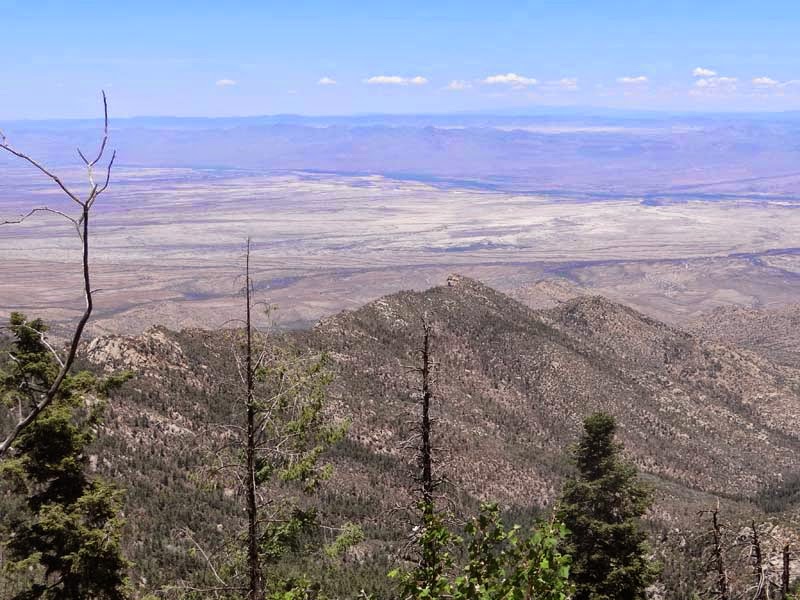
This weekend we are planning on a two day trip to Mount Graham. Mount Graham is a sky island in eastern Arizona with elevations on the top in excess of 10,000ft while at the base it is around 3,000ft. The drive up to the top is one of the most beautiful drives with great views from the many overlooks along the way. It is paved up to the first developed campground after which it is a good dirt road for the next miles until ending at the a trailhead at the far end of the plateau. We are getting late up so we just do a short trail for great views before finding a campspot for the night on one of the few sideroads with undeveloped campgrounds.
 |  |
| Where we want to go | Idyllic place on the plateau |
 |  |
| Yes - bears are here | Trail going towards higher elevations |
After a good night sleep we wake up only to see two rangers pull up in the same parking spot it seems in order to make a survey of the wildlife in the area. We decide to leave and eat breakfast at a more quiet area that we find relatively fast in a beautiful setting with a creek nearby. As we eat we study the aspen nearby only to notice a small bird bringing food to a nest high up and we study her as we eat as she brings insect after insect to the young in the nest.
 |  |
| Aspen forest | Where is he going? |
 |  |
| Ah..must be a nest | Exiting the nest |
Next we go to a close by hiking trail which leads down the mountain but we do only a short part of it until we reach a cave that we explore and then return back to the trailhead and car.
 |  |
| View from trail | Lizard doing gymnastics |
 |  |
| A crack in the earth | Narrow passage |
It is past noon already so we decide to explore the length of the road on the top and drive to the end where a hiking trail starts. The parking area is empty and all signs are destroyed so we don't know the length of the trail but anyway we just want to explore a bit for less than half an hour and the trail has great views really soon with views quite far in distance. It is a trail that we plan to explore in the future as it looks like a remote and beautiful area.
 |  |
| Not a lot of information | There is a trail here |
 |  |
| What a view | We are on a sky island |
On the way back we stop at Riggs Lake a very popular spot for campers and fishermen but it is too crowded so soon we move on.
 |  |
| Beautiful bird | Mountain lake |
On the way we stop at an interesting road sign not sure why this creek is marked. We find out soon as there are some nice canyons and also a lot of spring flowers on the creek side - a really peaceful place (except for the cars passing by).
 |  |
| What is so special about this creek? | Now we get it...nice canyon |
 |  |
| Wildflowers in the canyon | Another beautiful flower |
The next trail is the longest one for the day as we are searching for bigfoot (that is what the sign says) for about 2 mi through some nice forests with some pretty views and lots of wildflowers. We don't see the bigfoot and not even a deer only a few squirrels on the side of the trail.
 |  |
| Really? Bigfoot? | Destruction on the mountain |
 |  |
| Nice green area | Flowering tree |
The last trail for the day is a short trail toward Heliograph Peak. We do not intend to reach the Peak but to stop at the first view of the valley so we go off trail a bit which is more challenging than expected. But the views at the end are worth it and we enjoy the challenge. After this we have to go down the mountain and then drive back to Phoenix as the next day is a work day and even so we arrive after midnight at home.
 |  |
| Trail towards Heliograph Peak | I think we lost the trail |
 |  |
| Getting to a viewpoint | Impressive |
 |  |
| Wonder how far we can see? | Heliograph Peak Antennas |


No comments:
Post a Comment