Today we start our week long trip through Utah and Colorado with a long drive through Arizona. We stop only a couple times to stretch our legs but still see an interesting huge spider on a dirt side road that we explore for a few minutes.
 |  |
| Spider found near the road | Dirt road in Arizona |
We spend the night in Monticello before starting with our first day of exploring the area around Monticello. In fact the view from the hotel site is already very impressive with huge mountains lost into clouds like in wilderness movie.
 |  |
| View from the motel | Motel Room |
 |  |
| View of mountains in the distance | Close up of mountain in the clouds |
As we can continue south on our trip we stop to take in the views of the mountains and also to see the Recapture Reservoir which is quite large and even has a few lost looking ducks.
 |  |
| Nice view of the mountains in the clouds | Recapture Reservoir |
The next area that we explore is the Cottonwood Wash area. It is an interesting area with many autumn leaves and also a few ruins both ancient and more modern. We climb at a few ancient ones that are perched precariously above the wash in order to explore them and enjoy the great views.
 |  |
| Unknown ruin near a vegetated wash | Dry leaves on the ground |
 |  |
| Close up of cliff and ruins | Modern ruin |
The signs of human presence are not only above ground but also below ground with many mines dotting the area. The most interesting one is an old uranium mine bu there are many others to explore from a safe distance.
 |  |
| Old uranium mine | Cannot go further |
After exploring a few side roads we return to the main road to explore the main wash and we find a beautiful area of pools, rapids and small waterfalls which is quiet now but probably it is a lot more lively in spring.
 |  |
| Interesting wash | It even has water |
Next we stop for a walk across one of the many canyon rims in the area. After a short hike we are treated to some great views of slot canyons and mushroom like formations. This is an area that doesn't stop surprising us with the many interesting spots wherever you go.
 |  |
| Mesa Rim | Close up of rock mushrooms |
 |  |
| View of a side canyon from the distance | Slot canyon |
Going a bit farther we look for Anasazi ruins and while we find some suitable rock cavities we do not notice anything man made but still the sights are beautiful. While walking we are careful however to avoid the crytobiotic soil which seems to be everywhere around here and which supposedly takes years to grow.
 |  |
| Huge rock cavity | Interesting canyon |
 |  |
| Cryptobiotic soil | Very similar to mountains |
We stop a few more times to look at the views and interesting rock formations while driving towards our last goal in the area the Mule Canyon ruins.
 |  |
| Interesting rock formation | Nice view of the area |
The Mule Canyon ruins that we visit today are well preserved with a short paved trail through them and they are interesting enough for a short stop. The kiva is especially impressive and well preserved and we walk around it trying to imagine how it must have looked with a roof and people milling around them.
 |  |
| Plaque at the indian ruins | Kiva from afar |
 |  |
| Close look at the kiva | Old fountain |
After this we return back to Monticello and eat dinner before doing a nightdrive up a paved road until we get into the snow area and walk a bit using our flashlights and the moonlight in the snow before returning to the hotel for the night.
 |  |
| Eating late at night | Food at the only open restaurant in Monticello |
 |
| North Fork Mule Canyon Indian Ruins |
Today we want to walk a trail in Mule Canyon that we couldn't the day before due to the falling darkness and basically follow the same roads towards the Mule Canyon. We pass the diner where we ate last night in Monticello before arriving in Blanding where we want to visit the Dinosaur Museum. Unfortunately it is closed for the winter so we visit another small history museum in Blanding with some interesting exhibits before continuing towards the Mule Canyon.
 |  |
| Diner in Monticello | Dinosaur Museum |
 |  |
| Blanding Museum exhibit | Another interesting exhibit |
We find the parking lot relatively easy as we explored the day before a bit and then start in the opposite direction of the official trail to explore the canyon a bit. Here it is barely a canyon actually but the water is flowing quite nicely through the rocks and we enjoy exploring and even find some artifacts gathered on a stone by previous explorers of the area.
 |  |
| North Fork Mule...Canyon? | This is more canyon like |
 |  |
| View of the pictoresque canyon | Interesting collection near the parking spot |
After this diversion we go on the official trail through the North Fork of the Mule Canyon, the trail starts a bit difficult to follow but soon it is clear that it follows the wash through the canyon and we relax enjoying the canyon as it starts to deepen. It also gets colder, we even see some ice from time to time.
 |  |
| Tough to find trail | This is better |
 |  |
| Rare moss at the side of the road | And ice..it is cold |
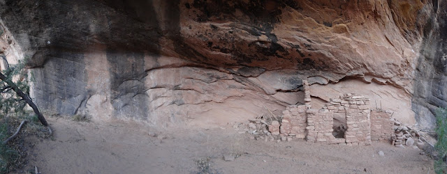
One of the reasons we chose and wanted to do this trail is that it has quite a few petroglyph sites and also some cliff dwellings. The problem is finding them so we keep our eyes on the canyon wall and are rewarded soon with some pictographs and then a small cliff dwelling. Exploring the cliff dwelling we find a huge shell obviously here due to trade as it is an ocean shell as far as we can tell.
 |  |
| First pictograph near the trail | A dwelling embedded in the rock |
 |  |
| A view of the wall | It doesn't look that safe |
 |  |
| View from the inside | Shell found at the site |
We stop at an interesting natural shelter to have lunch and enjoy the views before continuing past a few holes full of water along the canyon floor. The canyon starts to open up a view and the views become more expansive - it is very beautiful.
 |  |
| Exploring the canyon | Canyon wall |
 |  |
| View from above | Interesting waterhole |
 |  |
| Another view of the canyon | Almost fallen tree |
With all the looking around we almost miss a small Anasazi building at the top of the cliffs - it looks like a guardhouse for those that were guarding the entrance to the canyon.
 |  |
| Lookout tower or granary? | View from the back - it looks more like a fortification |
 |  |
| Towards the end of the trail | Nice canyon view |
Our turnaround point for the hike are the largest remnants of Anasazi structures in the canyon after about a 3 mile hike in. Here the buildings are well preserved, a kiva is visible in front of the building and there are both petroglyphs and pictographs. And we almost passed this as it is behind some bushes only luck made as investigate a side trail and finding the complex.
 |  |
| Well preserved ruins and kiwa | Well defined petroglyph |
 |  |
| Very similar to what we have seen in South Africa | Another well preserved ruin |
Walking back we examine the canyon again for additional Anasazi ruins and petroglyphs with no luck. But we enjoy the greenery where there is seepage of water in the rocks - it is quite special.
 |  |
| There is water (at least sometimes) | Rock formation? |
 |  |
| Trail while walking back | Ice is everywhere |
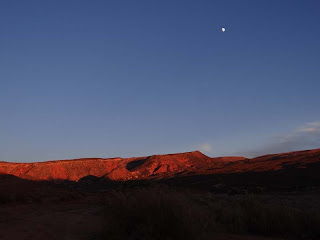
Back at the car we enjoy a beautiful sunset before returning back to Monticello and then driving on towards Moab where we will stay the night.
 |  |
| Beautiful sunset | Another sunset view |
The hotel is quite good and we like that it even has a coffee maker with a lot of cup variety that we try out during our stay. But today after getting some provisions from a nearby shop we go to sleep as we are quite tired after our hike.
 |  |
| Room in Moab | Complicated coffee maker |
We start the day with a breakfast at a nearby diner which is good and gives us energy for the day, today we have plans to hike in a few canyons near Moab and find some of the many petroglyphs in the area.
 |  |
| Breakfast in Moab | Interesting breakfast crepe |
First we start along the Kane Creek Boulevard and stop at a day area with a nice side canyon for a short hike before continuing on. We pass quite a few fields along the way some with donkeys browsing the grass as we search for the side road reading to the petroglyphs.
 |  |
| Side canyon in Moab | Donkeys on a field |
We finally find the correct road and start the short hike along the dirt road looking carefully at the walls and rocks until we finally find them. Some of them are quite interesting - a row of humans (aliens?) holding hands as well as one done basically via acupuncture of the rock (the figures are traced via multiple holes in the rock - it is the first time we see this method).
 |  |
| Hiking near Kane Creek Road | Great views |
 |  |
| And some rock art | Different way to create rock art |
After our hike we continue the drive down Kane Creek Road through some nice riparian area and beautiful canyons towards another place that we want to explore. While it has petroglyphs what we want to see is the dinosaur print rumored to be in the area. We explore and explore and finally find it - it is barely visible but it is clearly a footprint from the past.
 |  |
| Kane Creek and rock formation | Fall is in full swing |
 |  |
| Where is that dinosaur print? | Here it is |
We then continue on to the petroglyphs which are more classical here but we still find one in the new "acupuncture" style that seems to be common in the Moab area. To us it seems actually that the "acupuncture" style is actually better at preserving the figures that are drawn but there is no way to know without more research.
 |  |
| Now to find some petroglyphs - somewhere | Aliens abducting bighorn sheep |
 |  |
| Row of sheep | Sheep done using the second method |
After this we return to Moab and explore the downtown area a bit entering the different stores and looking for some of the historic buildings in this tourist town. We buy a few souvenirs also before returning to the car and driving to the last goal for the day, the Moab Brands trails area, named after the fact that the trail names are based on cattle brands that spell out the name Moab.
 |  |
| Moab museum with weird statue | Moab theater |
For the reminder of the day we walk the different trails some with dangerous names like Deadman's Ridge trail with some great views of the nearby mountains and even Arches National Park which is close by. The sunset especially lights up all the red rocks very beautifully and we enjoy them until the darkness falls and we start descending to the car.
 |  |
| There is snow on the high mountains | Interesting rock formations |
 |  |
| Very dry desert | Close up of formation |
 |  |
| Sunset view of red rocks | Some are quite impressive |
After returning to Moab we decide to go for dinner at a BBQ place which is quite interesting with lots of pig related artwork and of course also has good food. After that we return to the hotel to prepare for the next day and then go to sleep.
 |  |
| Very filling food | Funny |
 |
| Dead Horse SP View |
Today we have planned a long drive to Vernal with multiple stops at interesting sites. After a relatively short drive we arrive at the turnoff to the first attraction - Dead Horse Point State Park. The road is quite impressive as it climbs up and then follows a mesa with some great views of the red rocks and buttes in the area.
 |  |
| Red rocks view | That is our road |
 |  |
| Monitor and Merrimac Buttes | Interesting formations are everywhere |
Towards the end of the road you can either enter Canyonlands NP or the Dead Horse Point SP and because we have been to the National Park before today we are visiting the state park. After paying the entrance fee we soon are on the trail that goes around the point for some great views. The best views are of the Colorado River Bend which is quite impressive but we also like the views of the evaporation salt pans and the canyonlands surrounding the point.
 |  |
| Dead Horse State Park view | Colorado River Bend |
 |  |
| Close up of bend | Salt evaporation pans |
 |  |
| Impressive view | Snow on high mountains |
After returning to the main road it is a short distance to the next attraction the Copper Ridge Dinosaur Tracks. We have seen one print the day before but here we hope we can see a few more. We park the car and then after a short hike we are in the general area of the prints and then soon notice them as they are helpfully marked. We notice that some of them have water poured in them by other visitors and those are much clearer but overall just seeing the tracks of the dinos is quite exciting.
 |  |
| Somewhere there are dinosaur tracks | They are circled |
 |  |
| One example | If you pour water it is much more visible |
 |  |
| Without water | With water |
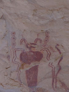
Next and last stop for today is Sego Canyon. It is an area that we found about when researching what to do and we were really impressed with the petroglyphs so we made it as a must stop in our trip. We find the petroglyphs easily as it is a developed site and soon find the ones that fascinated us - red pictographs of alien like humanoid pictures.
 |  |
| Sego Canyon Panel - impressive | Another of the many panels |
 |  |
| This is by far the best panel | Alien like pantings |
We zoom in on a few of the pictographs and they are quite special - these likely shaman or spirit representations are quite different than everything we encountered before in the Southwest.
 |  |
| Close up of a mysterious figure | Very intricate drawing |
After enjoying the pictographs we continue on the road through the canyon past an old pioneer cemetery (where we stop for a few pictures) towards the Sego ghost town.
 |  |
| Impressive formation | Old pioneer cemetery |
We know we are getting close to the ghost town when we start seeing ruined buildings and even the trestles of an old railroad bridge (or so we assume).
 |  |
| Old ruin in Sego Canyon | Former railroad bridge(?) |
Soon we park in the middle of the abandoned town and start exploring the buildings - one is still standing while the other ones have been flattened since the town has been abandoned. There are also rusting cars, fridges and other domestic junk deposited here, we like to explore this also especially an old rusted car that shines in the evening sun.
 |  |
| Sego ghost town building | Inside the building |
 |  |
| Not all of them are well preserved | Abandoned car |
While examining the ruins and enjoying the silence in the canyon we suddenly here some noises in the bushes. We start to investigate and are spooked when suddenly we are face to face with a few deer who are less shocked than us and slowly move away.
 |  |
| Surrounding canyon | Sun is setting |
 |  |
| Looking at us | You can't see me, right? |
After returning to the main road the night falls quickly so we drive straight to Vernal where we will spend the following two nights. The hotel chosen is quite great with our suite looking nice spacious and well appointed. We are tired after the day so after dinner in the room we soon fall asleep.
 |  |
| Nice touch in our room | Very spacious |
In the morning we start with a short exploration of Vernal, the gateway to the Dinosaur NM. As such we are not that surprised to see the large scale dinosaur downtown but we are surprised at how he is dressed - it is quite funny.
 |  |
| Ok - this is weird | A bit diabolical? |
Another attraction in downtown Vernal is the brick bank building. When it was built the post office had a flat rate for all parcels and because the cost of freight for shipping all bricks was prohibitive the builder decided the ship each brick individually by parcel. While they finished the bank it also led to changes in the postal service rules to ensure that no further buildings will be shipped through mail. After this we start towards Mc Conkie Ranch stopping just to take pictures of a pioneer cemetery and a few geese and llamas on the way.
 |  |
| Bank sent through the postal service | Historic cemetery |
 |  |
| Geese on the fields | And llamas?! |
We stop once more for a short hike in a nice looking side canyon where we even find a few petroglyphs before arriving at McConkie Ranch.
 |  |
| Hope it doesn't fall on us | Some petroglyphs |
The claim to fame for McConkie Ranch is the huge number of petroglyphs on the rock faces on this private ranch that can be seen from the trails through the area. But the start already is quite weird with the parking lot surrounded by a wooden wall covered with antlers. It takes a bit to find someone to pay for the entrance and then we are on our way. As the trail goes towards the cliffs we enjoy the nature - there are birds everywhere and likely also some of the many deers (even though we don't see them this time :)).
 |  |
| McConkie Ranch Trail | There are lots of deers..it seems |
 |  |
| Bird near trail | Eagle nest..we think |
The walk is quite scenic even without the petroglyphs but we are still happy when we get to the wall and start seeing the first petroglypphs. We are not always sure what is ancient and what is new but they are quite interesting and unusual.
 |  |
| The whole area has petroglyphs | Human like but natural |
 |  |
| These are not typical | Interesting art work |
One of the more recognizable petroglyphs here is the one of two feet without any torso and head - is it intended to be comical or is there something else? But there are also some well done drawings reminescent of Sego Canyon of shamans/spirits/aliens but they are not drawn in red color as in Sego Canyon.
 |  |
| Fun and weird one | Another weird one |
 |  |
| One of the older panels | We come in peace |
 |  |
| We can be friends.. | ..let's hold hands |
However by far the best drawings are high on a ledge at the end of the trail. They are done in color and arguably quite large given how well we can see them even from the bottom. We look at the details for some time especially at a dark red ghostly figure before returning to the car as we still have one more goal for the day.
 |  |
| Some are at a distance | UFO? Sun representation? Random scribblings? |
 |  |
| This is by far the best panel | Very nice detail |
What we intend to do is drive through the mountain to Flaming Gorge National Recreation Area and Wyoming to see the lake and also do some hiking. While we get there there isn't that much time to hike so we just go to the overlooks to get some pictures before starting to return towards Vernal.
 |  |
| Going to Wyoming | Wyoming countryside |
 |  |
| Flaming Gorge National Recreation Area | Beautiful but cold |
On the road we have to be careful to avoid the deer who are everywhere and don't really care about cars it seems or about anything else. And they also look cute on the side of the road:)
 |  |
| Can you see them? | Look at me! |
 |  |
| Should I pass? | Why not? |
Before descending from the mountains we stop at a trailhead for a short walk in the snow - who can resist snow if you don't see it for years? It is the start of a long hike but we do only a short part until the darkness falls and the cold is really biting when we return to the car and descend into Vernal. It is Thanksgiving and nothing is open so we are lucky that we have some provisions to survive the evening;). After that we go to sleep looking forward to visiting the dinosaur quarry tomorrow.
 |  |
| Short hike in the cold | Ice and snow are everywhere |
Today we are leaving Vernal and after visiting Dinosaur NM are planning to drive to Grand Junction Colorado where we will spend the night. After breakfast we leave for Dinosaur NM where our major goal is to see the dinosaur quarry. In this period we can visit it only with a tour starting at the visitor center so we reserve our places and wait for the tour. To our surprise the tour is by private car but following a ranger lead car that opens the door to the quarry. This is good as it means we can leave whenever we want without waiting for other people but first of course we want to see the quarry. The building is impressive from the outside and after the ranger unlocks the door we are in. The walking path is split over two levels so you can see the fossils from multiple angles and also allows the visitors to spread out which is good.
 |  |
| Dinosaur NM - protective hall | Fake example dinosaur |
 |  |
| Walkway near the dinosaur bones quarry | Top level walkway |
The quarry has lots of interesting bones it is surprising how many of them there are mixed together in this geological strata that is exposed in the museum.
 |  |
| Quarry view | So many bones |
 |  |
| Close up of one fossil | This is impressive |
The most impressive ones have been taken to other museums but there are still reproductions here of a full skeleton found here and the skull of another dinosaur. It is quite fascinating and we walk round a few times to make sure we don't miss anything before returning to the car to continue the visit of the park.
 |  |
| Accumulation of bones | Close up of skull |
 |  |
| Rconstruction of allosaurus | Impressive scary skull |
We continue down the road to a few more points of interest including a small Indian ruin next to the road with a few petroglyphs.
 |  |
| View of Dinosaur NM | Lots of skeletons in this ridge |
 |  |
| Indian ruin | There are even some petroglyphs |
One of the most beautiful areas in Dinosaur NP in our opinion comes next however with the Green River flowing through the badlands and creating a green corridor through this arid area.
 |  |
| Green River overlook | Going down towards the river |
 |  |
| Close to the river | It is quite big |
And where there is water there are animals - here deer specifically. They are not stressed at all by us which is good as we can take a few great photos.
 |  |
| Very calm deer | Interested in us |
We continue a bit farther, park the car and start hiking through the backcountry for a few hours and enjoy the great views and the solitude of this great area. But soon it is getting dark so we start back towards our car.
 |  |
| Walking through the backcountry of the NM | One of the rock formations near the trail |
 |  |
| Riparian area | Our "walking trail" |
 |  |
| Beautiful vista | Sunset is coming |
Before exiting the national park we stop at one more petroglyph area on the way - the petroglyphs here are also interesting - it seems that almost all petroglyph panels here have at least something weird.
 |  |
| Petroglyphs on the way | Wonder what the story is behind this? |
Before leaving for Grand Junction we also take a few photos of the surreal sunset and then we are on our way - the road goes through the mountains but it is still open and we are there at a reasonable hour and fall asleep really fast after our long day.
 |  |
| Nice sunset view | Beautiful |
Today our plan is to visit Colorado NM before driving towards our last accomodation in this trip in Cortez. We have been in Colorado NM some years ago and we are looking forward to see again the red rocks and weird formations. But first we have to drive up to the Rim - it is a nice drive and we stop a few times to take photos of birds and of course the scenery because as we ascend the views become also more impressive.
 |  |
| Starting towards Colorado NM | One of the first views |
 |  |
| Watching us | Beautiful lichen |
Of course the views from the Rim are even more impressive and there are quite a few overlooks where you can stop, exit the car and just enjoy the expansive views.
 |  |
| Impressive view | People like to climb this |
 |  |
| Another view of the valley | As far as the eye can see |
We take a few small hikes also to some views of the rock formations that Colorado NM is famous for. And they are quite beautiful especially in the falling sun and we even see a person climbing the most dangerous rock needle among the different formations.
 |  |
| Pipe Organ view | Another view - quite beautiful |
 |  |
| Great view of the formations | Impressive |
Last stop before descending down and starting the drive to Cortez is at the coke ovens. These were the formations that we enjoyed most last time and we are impressed again today. They are have a very interesting shape and in formation really look like coke ovens. After this last stop we drive to Cortez where with some difficulty we find our hotel and go to sleep before our last day of the trip.
 |  |
| Coke ovens view | Close up of the coke ovens |
This morning on the last day of our trip we splurge for a breakfast in a restaurant - it looks like in a movie with townfolk gathered and looking at us with suspicion (or at least it feels that way) but the food is good and soon we are on our way.
 |  |
| Good morning food | And very filling |
This day is dedicated to the different ancient ruins in the area and we start with Sand Canyon Pueblo in Canyon of the Ancients National Monument. We walk just a short bit on a long trail to the first pueblo. Here we see how an unexcavated pueblo looks like it is surprising how unassuming it is - you can barely notice the ruins in the vegetation but with the interpretative signs we get a good idea how the pueblo looked in its heyday.
 |  |
| Sand Canyon Pueblo - not much left | Unexcavated ruins |
Next we visit Lowry Pueblo which is also part of the Canyon of the Ancients National Monument. It was excavated in the 1930s and its big attraction is the well preserved big kiva and the big building protected by a modern roof from the elements. You can enter the big building and we do that and explore the areas that are open to the public - quite interesting to enter one of the old Anasazi buildings.
 |  |
| Lowry Pueblo view | Protected structure |
 |  |
| Entering into the structure | Inside a kiva |
 |  |
| Close up of rooms | Huge kiva at Lowry Pueblo |
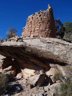
Our last stop in the area is in the Horseshoe/Hackberry part of the Howenveep NM. It is a short drive of the main road for the first stop, the Horseshoe Tower that can be seen in the distance. It looks very impressive so we decide to hike to it and seeing it from close up we do not regret it - it is really special and there aren't that many towers preserved from the Anasazi times. On the trail there are also two more pueblos to see - they are not that impressive but still add to the sense of how populated this area was.
 |  |
| Horseshoe tower in the distance | Getting closer to the tower |
 |  |
| Below the tower | Another view with the window |
We then continue on the road to the parking lot for the Holly group. It is a short hike to them but quite worth it as the ruins are well preserved and impressive. There are some towers but the main attraction is the double walled house - it looks like a fortified castle. After exploring the ruins for some time we return to the car and start the long drive back to Phoenix.
 |  |
| Holly group | Interesting ruin |
 |  |
| Is this a double wall? | Yes it is..quite well preserved |
 |  |
| Tower in the distance | Close up of tower |
On the way there is still time and light enough for us to stop in a roadside parking area for some views of Monument Valley in the sunset. We always liked this formations and they are even more spectacular during the sunset. And then in the dark we continue back to our home to rest after these great days full of exciting things to see in Utah and Colorado.
 |  |
| Monument Valley in the evening | Impressive in the setting sun |


No comments:
Post a Comment