Even though we live in Arizona for more than five years and we have travelled to Namibia, Japan and Australia during this time span we have never been across the border to Mexico. Part of it is the fact that it is so close that it feels that we can always go there if we really want to and part of it is just a general uneasiness after hearing all the bad news in the recent years about Mexico. But finally we decided to put all that behind us and start with a relatively short trip to Cabo - the extreme tip of the Mexican peninsula. As soon as we buy the plane tickets in September a powerful category 3 hurricane, Hurricane Odile, hits the peninsula (the largest ever to hit the area!) and this really seems a bad sign for our trip in November. However the news of cleanup are encouraging so in the end we decide to go ahead and do the trip - 3 months have passed so hopefully most important things have been fixed.
The airport as land seems newly painted and you can still see parts were they are working on it but the passage through customs is uneventful and after exchanging some money we exit to get our rental car. However this is not as simple as we expected as there are no window offices for car rentals and there are just people standing with signs and our car rental company is not among them. After asking around and nobody having any idea we go with our backup plan. Yes this is the only time ever that we actually had a car rental backup plan as we read online that the car rental companies cannot be trusted on the online rates quoted (they force you to take insurance even if it is included already and so on) - we had no idea that we won't even be able to get to the company. Our backup company has a driver in the mass of people and soon we are at the office (Alamo) - they are really professional and honor their online pricing until we have to get the car when we get a sales pitch for a timeshare company (if you get to a presentation they will greatly reduce the price of the car and so on) but we escape soon and are on the road.
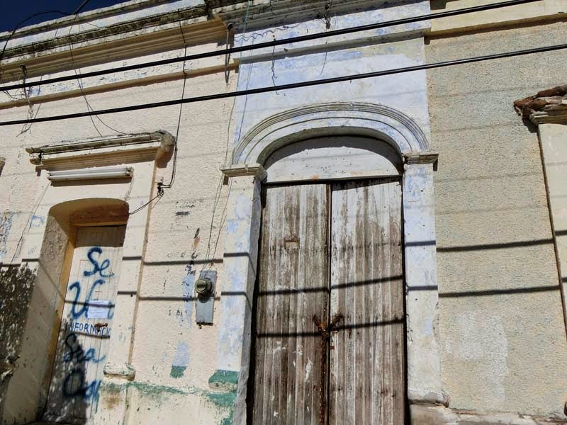
Our hotel is not far away (only a few kms) and even though the street is quite busy we enjoy looking around taking in the atmosphere, examining the destruction wrecked by the hurricane (shops shuttered and destroyed, signs fallen by the roadside and so on) and learning the rules of road in this part of the world especially with many traffic lights still out.
 |  |
| Major road through Cabo | Overpass - useful with the traffic |
The central area of the city is a bit confusing with a lot of one way streets and even after we find the hotel we cannot find the parking area so we have to go inside and ask and finally we find the correct street to enter the parking lot. Checking in is fast and the room is nice looking and clean. The hotel has a pool and more important for us a few parrots and cockatiels that we have to study for some minutes.
 |  |
| Tropicana Inn room | Colorful sink |
 |  |
| Pool and garden | Cabana and hotel |
 |  |
| Parrots in front of the reception | Cleaning itself |
After resting a bit we decide to visit the downtown area which is right next to our hotel. The main street in front of the hotel is very busy and it is almost impossible to find a parking spot and it ends in a pedestrian area. in this plaza the first sight is the city hall - it looks unaffected by the hurricane it is impressive given the state of the reminder of the city and we enter the central courtyard for a few pictures before moving on to the main area of the plaza Mijares.
 |  |
| Main street of San Jose del Cabo | A popular bar/restaurant |
 |  |
| City Hall | Interior of city hall |
Plaza Mijares is quite empty given the number of cars and even the street vendors seem bored. It looks like a break in the activity of the city with the only activity being the building of a huge Christmas tree in the middle of the plaza. We pass through the plaza to take a look at the mission church of San Jose del Cabo Anuiti. The sun is behind the church so it is difficult to see details but inside it looks relatively austere for a Catholic church.
 |  |
| Central Plaza | Building the Christmas tree |
 |  |
| Mission de San Jose del Cabo Anuiti | Interior of the church |
 |  |
| View of plaza from the church | Shade is always good here |
We also take a short stroll through the art district but everything seems close and we are not sure if it is due to the hurricane or just due to the midday fiesta. We hope it is the latter as we have chosen the time of our visit so that it coincides with the Art Walk on the Thursday which is later tonight. But nothing is happening now so we return to the hotel and the car as we have to buy provisions for the whole trip.
 |  |
| Art district of town | Colorful house |
 |  |
| Interesting mosaic | Repairing car on the street |
We plan to go to a Walmart that we found on the map but we cannot find the way to the entrance (incredible, right?) and settle for another supermarket, Mega, that we find nearby. It is clearly affected by the hurricane with half of it empty, haf of the remaining under repair and the few aisles remaining being quite empty and some of the products clearly being pre hurricane as the packaging is affected. We still find things to buy to last as the days that we are staying here but there is still a lack of diversity in the offer.
After bringing the food home we go out for the Art Walk. This time the town is packed and all artist studios are open so we have fun walking and exploring them. Unexpectedly the prices are really high - higher than in the US so we decide not to buy anything but we enjoy the walk nonetheless. After that it is back to the hotel to prepare for the next day.
After breakfast our first goal is to go to the estuary hiking trail while it is not yet hot outside and then go to Cabo San Lucas while visiting beaches and any attractions we can find on the way. But before that we first have to go downstairs and exchange some additional money from the hotel reception in order to make sure we have enough for any eventuality as at the airport we exchange only a limited amount given that the exchange rate was not the necessarily the best and we were hoping from better luck in the city.
 |  |
| Tropicana Inn interior court | Reception area |
We start with a short walk in the neighborhood looking for a bakery that we wanted to use the following day for breakfast. Wandering around we arrive again in the front of the cathedral which today is more easy to take a picture off as the sun is in a better position and we can even enter from a more convenient door given that there are fewer people.
 |  |
| Hotel from the main street | Fun name for a cigar shop |
 |  |
| Mission church in the morning light | Interior of church |
Finding the entrance to the estuary trail is more difficult than we expect but we find it next to the bridge hidden at the end of the wall. Very soon the trail is completely eroded from the hurricane and we can barely pass and we start to wonder if it is really open even though there are no closing signs at the start of the trail.
 |  |
| Destruction from hurricane | Start of trail |
 |  |
| Probably damage from the hurricane | Certainly damage from the hurricane |
The impact of the hurricane is much more visible here as the cleanup is focused on the city and the buildings. We even see a telephone pole in a canal that we are passing - the wind must have been really strong to do that. Soon after we see a huge iguana on the side of the road - and then another one - it seems like a colony of iguanas on these rocks.
 |  |
| Wow - it was hit pretty hard | Not where you expect to see a phone pole |
 |  |
| What is there? | A huge iguana |
The wildlife in the estuary is not limited to iguanas. There are ducks, egrets, herons and a lot of other birds enjoying the water - glad to see that they weren't impacted that much by the hurricane.
 |  |
| Lots of ducks | Taking off or landing? |
 |  |
| Egret searching for food | Just cleaning itself |
The trail opens up a bit afterwards and we even encounter other people with horses (so the trail is open). From time to time it is washed out but it is easy to go around and we have time to examine the flowers and the multitude of butterflies that are attracted by them.
 |  |
| Looks wild | Trail is quite impacted by the flooding |
 |  |
| Flowers near trail | One of the many butterflies |
Just when the trail is looking better and it seems that we will be able to do the whole walk the pavement simply ends in the water with no way around it so we are forced to turn around and return to the trailhead we entered in. On the way back however we see a turtle and again all the iguanas and ducks which makes it worthwhile.
 |  |
| Looks better | End of trail due to hurricane |
 |  |
| Duck enjoying the water | Turtle sunning itself |
After the hike we are hot and would like nothing more than a bath so on our way to Cabo San Lucas we are searching for the two major beaches that we know are on the way. They are not marked but with the guidebooks we find the correct exit for Playa Chileno (Chileno Beach). The parking is dirt but good and soon we are on our way to the beach. The first thing that jumps at us are the trashcans - those are the most imaginative that we remember seeing - great idea. It is a short walk to the beach and most people are grouped where the exit is so we walk a bit farther away and it is quiet and peaceful and we feel almost like we are alone on the beach.
 |  |
| Entrance to Chileno Beach | These are some imaginative trashcans |
 |  |
| Not that many people | All gathered on one side of the beach |
Near us are a few snorkeling boats which convinces us to also try the water in our snorkeling gear. If we carried the equipment with us why not, right? But first we have to set up for sunbathing and explore a bit the beach - there are a few crabs in the rocky area close by and even a dead fish that doesn't escape the attention of the few gulls in the area.
 |  |
| What ship is that? | Pirate ship?! |
 |  |
| A good place to sunbathe - no one close by | Rocky area |
 |  |
| Dead fish on the beach | Fish has visitors |
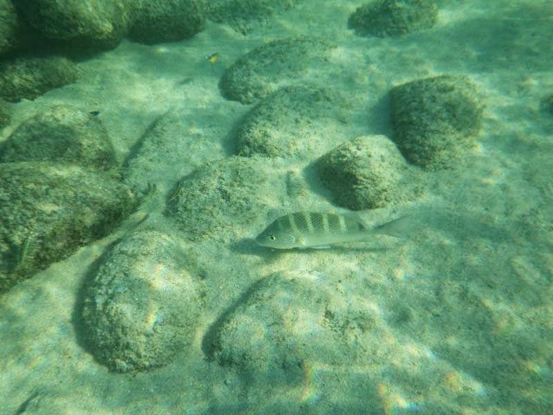
At first there aren't any fish but after getting a bit farther in the water we start seeing a few close to the surface of the water. Then as we move on we see another one bigger with yellow fins and following that one we find quite a few more searching for food on the bottom of the ocean.
 |  |
| Are there any fish in the water? | There they are - not that colorful |
 |  |
| This one is bigger and more colorful | And now a lot of them |
Closing even more on the snorkeling boat we find a reef area that is teeming with fish. There are so many different fish it is difficult not to gasp at the huge variety. We stay for quite some time just floating and enjoying the fish before exiting and then returning to the car as it is getting late in the day and we still want to see Cabo San Lucas.
 |  |
| Reef - but where are the fish? | That is more like what I expected |
 |  |
| Interesting fish | Bigger than it looks |
 |  |
| Small blue fish | "Zebra" fish |
Arriving in San Lucas we drive around a bit trying to find parking which is more difficult than expected. In the end we find a mall and park there for a fee and then start exploring the mall. Half of the stores are not yet open from the hurricane and the ones that are are not really that full so soon we exit on the harborside where we stop at Senor Sweets to eat some good sweets (what else?), quesadilla and a couple coffees and just relax.
 |  |
| Quiet part of Cabo San Lucas harbor | And this is the busy part |
 |  |
| Senor sweets - who can resist? | Local delicacy |
After this we look around trying to find some interesting shops but there aren't really that many except the same souvenir shops again and again. At least while walking on the dockside we see a few seals and a pelican which has us all excited. Stopping to look however is not an option as whenever you stop invariably some person would stop and try to sell you something from watches to other less legal things. Soon we return to the car and then back to San Juan in order to prepare for the next day.
Today we have a long day planned going to Cabo Pulmo on the east coast and then back stopping on the way and exploring the beaches of Cabo Pulmo. Leaving we are already used to the traffic in San Jose and with a four lane divided highway we make acceptable time however after the airport the highway becomes two lane only. Of course the traffic volume also decreases and the speed limit increases but each small village has a low speed limit with sometimes unmarked speed bumps so we have to be careful as we drive north. From time to time we encounter construction sites especially at bridges that were destroyed by the hurricane but overall the road is in very good condition just two months after the hurricane.
 |  |
| Divided highway - not for long | Main highway through Baja California Sur |
 |  |
| Repairs after the hurricane | View from the road |
Our first stop is at the Tropic of Cancer monument. This is the first time that we pass this tropic by car (weirdly we have passed the Capricorn one multiple times already) so we stop to take pictures and examine the monument. It is quite interesting actually with multiple globes, a few shops and a chapel and worth the quick stop.
 |  |
| Tropic of Cancer Monument | Memorial plaque |
 |  |
| Another globe showing the Cancer tropic line | Small chapel ceiling |
Next we want to stop at a waterfall, Zorro waterfall, that is not that much advertised officially. We know that the road starts from Santiago near the main road which is advertised as a village with a nice plaza. However when we arrive in the plaza there isn't much happening and many stores seem shuttered - again we blame the hurricane and start searching for the road to the waterfall. Using a road description we have we exit the town on a dirt road that overlooks some flooded plantation area and soon afterwards we find happily a sign pointing in the direction of the waterfall (cascada) and we start following it through the maze of dirt roads.
 |  |
| Downtown Santiago | Abandoned building downtown |
 |  |
| Guess that is the plantation area?! | Following the signs (only the waterfall is really there) |
The road to the waterfall is well graded and even our 2wd car can pass easily through the magnificent desert landscape with huge cacti and trees surrounding us on the way in. At the visitor center we pay the entrance fee and start our hike passing a construction site (future restaurant and accomodations?) and arriving at the trailhead start.
 |  |
| Dirt road to waterfall | Huge cacti on the side of the road |
 |  |
| Visitor center area | Start of trail |
The trail starts relatively level going through the dry forest where we can again see the devastation from the hurricane. Soon we arrive at a viewpoint from which we have our first glimpse of the waterfall - it is much bigger than expected so we decide to continue on to see whether the trail actually also descends to the waterfall pool.
 |  |
| Even here there is impact from the hurricane | Lots of green |
 |  |
| View of waterfall from viewpoint | Close up of waterfall |
 |  |
| Trail - well maintained | Butterfly near trail |
The answer is yes however the final descent is quite difficult as we have to descend quite a bit using stone stairs hewn out of the surrounding rockface. At least it has much appreciated shade so we can stop and catch our breath a few times. At the bottom there is another group of tourists but they are further away so we decide to enter the water a bit which is quite cooling after our hot descent. The waterfall drowns all sound of conversation as we are quite close to it and we stay a bit just relaxing before the unavoidable climb back to the car.
 |  |
| Going down - quite a few stairs | Shade - how great |
 |  |
| These look old - without them descent would be quite difficult | Looks peaceful |
 |  |
| And here is the waterfall | Quite big for this arid area |
As it is noon already we drive without stopping towards Cabo Pulmo. After exiting the main road on the side road to Cabo Pulmo the road becomes quite potholed and we have to go almost at a crawl in order to avoid the potholes. It is almost a slalom course and we are happy at first when we arrive at the dirt portion of the road. While without potholes the dirt road has rocks so we still have to drive carefully over the hills and through the washes in our way. At least we see a couple caracara resting on a roadside cactus which makes the drive a bit more exciting.
We pass Cabo Pulmo and identify the road to Playa Los Arbolitos that we are interested in. The road is a bit iffy but with some encouragement from a Mexican rancher we pass through the worst sandy part to arrive at the (sandy) parking lot. We pay for the parking (which should be free according to our understanding) and then look for the trail to the secret beach that we intend to visit. We don't find it and finally just go up the cliff face in the estimated direction.
 |  |
| Crested caracara resting | Parking for Playa Los Arbolitos |
On top of the crest we finally notice the path and go down to it and then continue on it. It is more precarious than we expected perched on the clifftop and hugging the cliffside but the views are great. Whenever we arrive at something too dangerous to pass we track back and use the crest to bypass the trail.
 |  |
| Trail to secluded beach | Sometimes it is easy |
 |  |
| Sometimes a bit more dangerous | View of the trail and coastline |
It is tough going and it seems that we will never arrive - there are no beaches in sight. Suddenly after a bend the trail descends and we are in a sandy area - still no beach but we can at least touch the ocean if we want to. The landscape also changed a bit - instead of the steep sandy cliffs there are hills full of boulders which is an interesting phenomenon.
 |  |
| Rugged coastline | Is there really another beach somewhere? |
 |  |
| A bit flatter | Natural or not? |
 |  |
| Stony Mountain | Looking down through the stones |
There are also more signs of wildlife here - from a few crabs to a pelican that seems to fly aimlessly over the water in circles.
 |  |
| Rare (in this area) cactus | Pelican flying around |
 |  |
| Crab trying to run away | Different type of crab |
And then we find the entrance to the beach (Sirenitos Beach is one name we have seen) between two cliff faces. It really is a secret cove with the water shallow and easy to enter with fish swimming almost up to the shore so we can't wait to enter the water to snorkel.
 |  |
| Entrance to the beach | Secret beach |
As the cove is protected the water is quite clear here and the pictures are much better compared to Playa Chileno. As soon as we enter and stand still the fish start to gather and we are impressed by a bright blue fish that stands out between its drab companions.
 |  |
| Water is quite clear here | Corals from the neaby coral reef |
 |  |
| Blue fish near us | And it brought a lot of friends |
Actually if you look close they aren't really that drab with a nice yellow/black stripe pattern. And the deeper we go the more fish we find - big schools which are great to follow and examine.
 |  |
| Very common fish here | Close up of black and yellow fish |
 |  |
| Bicolor fish | Large congregation of fish |
As the water becomes deeper we find our first corals and the fish mix changes and we run from one place to the other trying to take a picture of the most interesting ones.
 |  |
| Close up of coral | Fish on the ground |
 |  |
| Different fish inspecting the corals | Common but weird fish |
The most interesting fish we see and the only one that we can identify is a parrot fish - it is much bigger than the other ones so we keep a healthy distance from it - just in case. We don't want to exit however the sun is setting and it is getting cold in the water so reluctantly we go out change in dry clothes and walk back to the car. The drive back in the darkness is something else - trying to avoid potholes is one thing but when cows appear in the middle of the road and you have to break while someone is tailgating you that is a bit more scary.
 |  |
| Most common fish in the area | Following a fish |
 |  |
| Only seen this one | Quite big |
 |  |
| Parrot fish | Close up of common fish |
Back in San Jose our plan is to eat out tonight and we settle on Mi Casa one of the restaurants that seemed to have more authentic food and not burgers and pizza. We eat mole and a chicken dish and the mole is quite good. And as a drink we drink a margarita - which is as good as it can be. We are really tired after all this so we fall asleep as soon as we return to our room.
 |  |
| Mole dinner | Margarita glass |
After our trip on the eastern side of the peninsula the day before today we are trying the western side. What we intend is to drive to Todos Santos a village which was named a Pueblo Magico in 2006 and is supposed to be one of the more enchanting in Cabo. For this we have to drive through San Lucas and there we lose the road for a while and have to retrace our steps until we get the correct route out of the city. After that it is a nice four lane road up to Todos Santos. We catch a few glimpses of the sea from time to time and we even see a fire in the distance before reaching Todos Santos.
 |  |
| Road to Todos Santos | Fire in the distance (or at least smoke) |
Finding a parking spot proves again to be difficult but in the end we find one near the major hotel in the central area, Hotel California. There is a legend that this the Hotel California from the Eagles song but the composer denied this in an interview. Still it is interesting to imagine this being true and the hotel and shop is milking this to the max with everything from t-shirts to the hotel history. We start our visit by walking to the Central Plaza which to our surprise is completely empty of people. The plaza is surrounded by some nice looking buildings including the theater on one side and the church on another. As we continue walking we notice that the walls are quite destroyed in places, again likely due to the hurricane.
 |  |
| Hotel California shop | Downtown plaza - quite empty |
 |  |
| Small city theater | Hurricane or just not maintained?! |
The tourist area is quite small and while the houses are interesting looking and some of the interiors are richly decorated it doesn't seem so overwhelming as we were led to believe. A few shops are open and the offerings are interesting but again quite expensive. Soon we decide to return to the hotel as we are hungry and find something to eat at the restaurant.
 |  |
| Brick houses are common here | Close up of brick house |
 |  |
| Interesting house | Elevated sidewalk - tough to get to the street |
 |  |
| Mosaic on stairs | History of Mexico in a painting |
We order tacos and tostadas and both of them are average but good enough for two hungry travellers.
 |  |
| Food at Hotel California | Restrooms at Hotel California |
The other stop that we want to do while in the Todos Santos area is the La Poza estuary. We read it has a lot of birds so we are interested but getting there is again an adventure. The road is dirt and quite sandy and on top of that one lane so we have to drive as fast as we can but carefully. At the end it becomes deep sand so we park before we get into it into an area where other cars can pass and start walking. The estuary has a few birds but none of them that special and soon we decide to explore the nearby beach which looks deserted.
 |  |
| Trail to La Poza estuary | Egret on La Poza estuary |
 |  |
| Even a few ducks | Close up of ducks |
The beach is beautiful and great to walk however entering the ocean is impossible due to high waves. We walk at the edge of the ocean to look for wildlife but the only thing we find is a dead pufferfish.
 |  |
| La Poza beach - deserted | Waves coming in |
 |  |
| Poor pufferfish | Beautiful view |
Far in the distance there is a fishing boat which looks traditional to us and we examine it a bit to see whether we can understand what it is doing (we can't) before turning around and returning to the car as we plan to stop at at least one more beach today closer to San Juan.
 |  |
| Dead cactus near the beach | What time is it? |
 |  |
| Fishing boat coming in | Close up of boat |
The beach we plan to stop at is Santa Maria Beach the other major beach between San Juan and San Lucas. When we arrive the sun is already setting but the beach is still full of people enjoying the weather and the water.
 |  |
| Santa Maria Beach - very popular | Sun setting at Santa Maria Beach |
 |  |
| Beach end | Waves coming in |
The sand here is not as good as the one at Playa Chileno as it is more stony and the waves are too big making the water less clear. We also don't see as many fish as we have seen at the other beaches in the area so overall today likely is a bad day to snorkel here. However we see at least a loon and a few pelicans so there is at least some wildlife above weather. After it gets dark we get back to the car and drive to our hotel to rest for the night.
 |  |
| Close up of "sand" | Even closer - spot the differences:) |
 |  |
| Night is setting in | Much quieter in the evening |
As the plane is leaving in the evening we have almost a full day ahead of us but we plan to spend it near San Jose. First we plan to visit one of the beaches from San Jose - La Playita. In order to reach it we have to cross the bridge right next to the hotel that we have seen many times but never used. It goes over the estuary to the docks and then around them to the beach. The beach has black sand which surprises us and is quite empty of people. The water however holds some animals that we see skim the surface a few times - either dolphins or catfish we can't decide.
 |  |
| La Playita parking lot | La Playita - black untouched beach |
 |  |
| Now we walked on it:) | What are those - dolphins?! |
Next we visit the docks area which has a sculpture path but we aren't sure how to access it. Finally we park at a bar and then ask a military vehicle (of which we have seen a few) whether the trail is open. They say yes so we start on it. The sculptures (and benches) on the trail seem to have been submerged by the hurricane but now they are repositioned mostly correctly but some more haphazardly. Overall the sculptures are quite interesting so we go farther than we intended on the trail before returning.
 |  |
| Dockland path has been flooded by the hurricane | The gates to the boats are locked |
 |  |
| One of the statues lining the path | Birdman - moved by the water and repositioned |
 |  |
| This looks scary | Heron near the docks |
Next we return to the hotel to park as we still have time and want to explore the stores in the downtown area a bit more. We notice to our distress that the gas station next to the hotel is out of gas so we have to leave faster and hope we can find gas on the way so we can return the car as our rental contract is requiring.
 |  |
| Gas station with no gas | Mountains in the distance |
As we walk through the downtown area we pass by the restaurant we ate a couple of days ago which is quite colorful in the daylight. On the way we enter in quite a few shops and even buy a few things that we had our eyes on.
 |  |
| Restaurant where we ate a few days ago | Art above the door |
 |  |
| Typical streetside shop | Colorful things for sale |
 |  |
| Downtown is preparing for Christmas | Christmas tree with flag |
It is already lunchtime and we decide to eat at the bakery we explored a few days ago. It is one of the few things open and it specializes in crepes which is what we eat and they are good as expected. After this we have to leave the city to find gas which we find at the third gas station we look at - what is the chance of a gas shortage on the day we leave?!
 |  |
| One of the many sidestreets | Crepe place |
 |  |
| Weird looking crepe | They are quite good |
There are no surprises at the car rental company they even gave us a credit for a few hours that we did not use. The airport however was quite disorganized after we entered as our gate was moved around multiple times with no announcements made and with no electronic board of information finding this out was quite difficult. But we got on the plane finally and just as the sun was setting left Cabo. OVerall it was a great long weekend break and a nice introduction to Mexico - can't wait to visit it again.
 |  |
| Car rental place - destroyed by hurricane | Leaving Mexico |


No comments:
Post a Comment